
Method and device for detecting geological flaws at bottom of foundation pile holes through geological radar

A technology of geological radar and geological defects, which is applied in the testing of measuring devices, basic structures, detection with electromagnetic waves, etc. Manual drilling work, ensuring detection accuracy and depth range, and high on-site work efficiency

Active Publication Date: 2015-07-01
CHINA POWER CONSRTUCTION GRP GUIYANG SURVEY & DESIGN INST CO LTD
View PDF4 Cites 1 Cited by
  • Summary
  • Abstract
  • Description
  • Claims
  • Application Information

AI Technical Summary

Problems solved by technology

[0002] The foundation pile is the foundation of the building. In the construction of the building foundation pile, the pile hole is generally excavated first. After the excavation reaches the design depth, a drilling rig (air compressor or other drilling rig) is generally used to drill the bottom of the pile hole to a certain depth (generally It is 5 meters to 10 meters) to confirm that there is no cave at the bottom of the pile hole. This regulation is an industry regulation made by the building quality inspection department to ensure the safety of foundation piles, but foundation pile holes are generally excavated deep and small in diameter. , it is difficult to operate on site with the method of brazing, and the brazing is usually operated by front-line construction workers, and the existence of karst caves is determined entirely by hand feeling, so its accuracy is poor, and it is greatly affected by people's subjective consciousness, which has certain limitations
Therefore, the existing methods and devices for detecting geological defects at the bottom of foundation pile holes are still unsatisfactory.

Method used


Image

  • Method and device for detecting geological flaws at bottom of foundation pile holes through geological radar
  • Method and device for detecting geological flaws at bottom of foundation pile holes through geological radar
  • Method and device for detecting geological flaws at bottom of foundation pile holes through geological radar

Examples


Embodiment Construction

[0020] The present invention will be described in further detail below in conjunction with the accompanying drawings and embodiments.

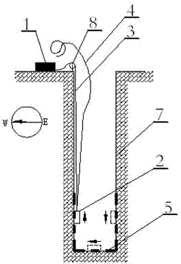
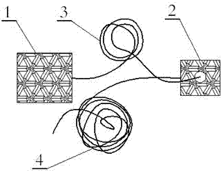
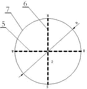
[0021] look first figure 1 , figure 1 Shown is the detection principle diagram of the east-west direction radar scanning of the present invention, the detection principle diagram of the north-south direction radar scanning of the present invention is similar to the detection principle diagram of the east-west direction radar scanning. Look figure 1 , figure 2 , the present invention has adopted a kind of geological radar to detect the device of foundation pile hole bottom geological defect, and this device is provided with frequency and is 270Mhz radar antenna 2, and radar antenna 2 is connected with described geological radar instrument 1 by radar antenna connection cable 3, and is provided with An antenna hoisting rope 4 and a pulley 8 are provided for retracting and retracting the radar antenna 2. Look figure 1 , image 3 , figure 1...


PUM


Abstract

The invention discloses a method and a device for detecting geological flaws at bottom of foundation pile holes through geological radar. The device comprises a geological radar instrument (1) and a radar antenna (2) with frequency of 270Mhz, wherein the radar antenna (2) is connected with the geological radar instrument (1) by a radar antenna connecting cable (3); and an antenna lifting rope (4) and a pulley (8) are arranged and used for deploying and retracing the radar antenna (2). According to the method and the device disclosed by the invention, the advanced geological-radar based karst cave detecting technology is adopted, and the structural features of foundation pile holes are fully utilized, therefore, the karst caves at the bottom of the pile holes and the karst caves within 10 meters from piles can be detected; the method and the device are large in detection scope, high in field working efficiency, and clear in karst carve detection; by adopting the method and the device, the works of mechanically drilling holes or artificially drilling holes can be avoided, and the existence, the depth and the scope of the karst caves at the bottom of the piles and the karst carves within the scope of the pile hole embedment depth in rock can be universally detected; and a new efficient and quick method is provided for inspecting and accepting the engineering foundation pile holes.

Description

technical field [0001] The invention relates to an engineering geological exploration method and device, in particular to a method and device for detecting geological defects at the bottom of foundation pile holes by using geological radar, which is suitable for urban construction, household construction, water conservancy and hydropower, road and railway, factories, mines and metallurgy and other industries. Foundation pile construction quality inspection and acceptance work. Background technique [0002] The foundation pile is the foundation of the building. In the construction of the building foundation pile, the pile hole is generally excavated first. After the excavation reaches the design depth, a drilling rig (air compressor or other drilling rig) is generally used to drill the bottom of the pile hole to a certain depth (generally It is 5 meters to 10 meters) to confirm that there is no cave at the bottom of the pile hole. This regulation is an industry regulation mad...

Claims


Application Information

Patent Timeline
Patent Type & Authority Patents(China)
IPC IPC(8): G01V3/12G01B15/00E02D33/00
Inventor 王波谭浩尹曜华
Owner CHINA POWER CONSRTUCTION GRP GUIYANG SURVEY & DESIGN INST CO LTD
Learn More