Line and surface type global information system (GIS) vector data disguise and reduction method based on interpolation prediction

A vector data and interpolation technology, which is applied in the field of camouflage and restoration of line and surface GIS vector data based on the interpolation prediction method, which can solve problems such as complex spatial relationships and achieve the effect of data protection.

Inactive Publication Date: 2012-11-28
NANJING NORMAL UNIVERSITY
View PDF6 Cites 0 Cited by
  • Summary
  • Abstract
  • Description
  • Claims
  • Application Information

AI Technical Summary

Problems solved by technology

Due to its specific data structure, various data organization methods, complex spatial relationships, high precision, and less redundancy, GIS vector data makes the research on information camouflage of GIS vector data special and difficult.

Method used


Image

  • Line and surface type global information system (GIS) vector data disguise and reduction method based on interpolation prediction
  • Line and surface type global information system (GIS) vector data disguise and reduction method based on interpolation prediction
  • Line and surface type global information system (GIS) vector data disguise and reduction method based on interpolation prediction

Examples


Embodiment Construction

[0046] Further detailed description will be given below in conjunction with the accompanying drawings and embodiments.

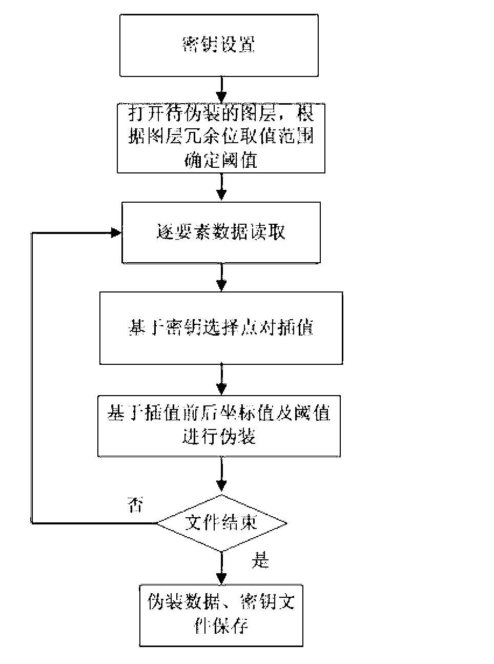
[0047] In this embodiment, typical shp format vector data is selected, and the present invention is further described in detail for the whole process of data reading, camouflage, and restoration. The present embodiment selects the national 1:4 million provincial boundary layer data (such as image 3 ) as the experimental data, the original random sequence is set to "10011100101001010011". (1) Camouflage process:

[0048] Step 1: Set a random sequence "10011100101001010011" in binary format, the length n of which is 20.

[0049] Step 2: Open the provincial boundary vector data file, determine that the starting bit of the redundant data of this layer is the third decimal place, and thus determine that the value range of the redundant bit is (0.001, 0.01), in the interval (0.01 , 10) Take the threshold T=1. Read the spatial data of each element in turn, obtai...


PUM


Abstract

The invention discloses a line and surface type geographic information system (GIS) vector data disguise and reduction method based on interpolation prediction, which belongs to the field of geographic information safety. The data disguise process comprises the following steps of: setting a key file, and reading data of elements one by one; performing interpolation processing based on key selection points, and correspondingly disguising the data according to data differences before and after the interpolation; and processing each element and saving the disguised data. After the data is disguised by the method, the coordinate value in an element layer is changed, so that the coordinate position deviates, and the data precision is changed. For the GIS vector data with a high data precision quality requirement, the data quality and the data application value are obviously reduced through the processing, and the normal use of illegally copying or data interception is limited, thereby protecting the data to a certain degree, and meeting the requirements on hidden communication and safety transmission of the GIS vector data to a certain degree.

Description

technical field [0001] The invention belongs to the field of geographic information security, and in particular relates to a method for disguising and restoring line-surface type GIS vector data based on an interpolation prediction method. Background technique [0002] At present, information hiding has become another important branch besides cryptography in information security research, and the two most important branches in information hiding are information camouflage (steganography) and digital watermarking. Although both information camouflage and digital watermarking adopt the mechanism of hiding information in form, they are quite different in many aspects such as purpose of use, object of protection, nature of secret information, communication method, performance requirements, and attack form. Among them, digital watermark is mainly used for copyright authentication, and information camouflage is a means of secret communication, which obtains the security of secret ...

Claims


Application Information

Patent Timeline
Patent Type & Authority Applications(China)
IPC IPC(8): G06F21/24G06F21/60
Inventor 李安波张驰闾国年
Owner NANJING NORMAL UNIVERSITY
Why Eureka
Try Eureka