
Method for optimizing spatial distribution of statistical data about crop planting area

A statistical data and spatial distribution technology, applied in data processing applications, calculations, predictions, etc., can solve the problems that affect the improvement of spatial information accuracy of crop statistical data and the decrease of micro information accuracy, so as to achieve the goal of enhancing usability and improving accuracy Effect

Inactive Publication Date: 2012-07-18
INST OF AGRI RESOURCES & REGIONAL PLANNING CHINESE ACADEMY OF AGRI SCI
View PDF0 Cites 43 Cited by
  • Summary
  • Abstract
  • Description
  • Claims
  • Application Information

AI Technical Summary

Problems solved by technology

Therefore, the accuracy of the spatialized statistical information is greatly reduced below the scale of the statistical data itself; in addition, the above methods all use integrated remote sensing technology to extract land use, cultivated land distribution or crop distribution as auxiliary information to realize social data. Spatialization, but the remote sensing information of the crop itself (especially the time series remote sensing information) is not directly applied, which affects the further improvement of the accuracy of the spatialization information of the crop statistical data to a certain extent

Method used


Image

  • Method for optimizing spatial distribution of statistical data about crop planting area
  • Method for optimizing spatial distribution of statistical data about crop planting area
  • Method for optimizing spatial distribution of statistical data about crop planting area

Examples


Embodiment Construction

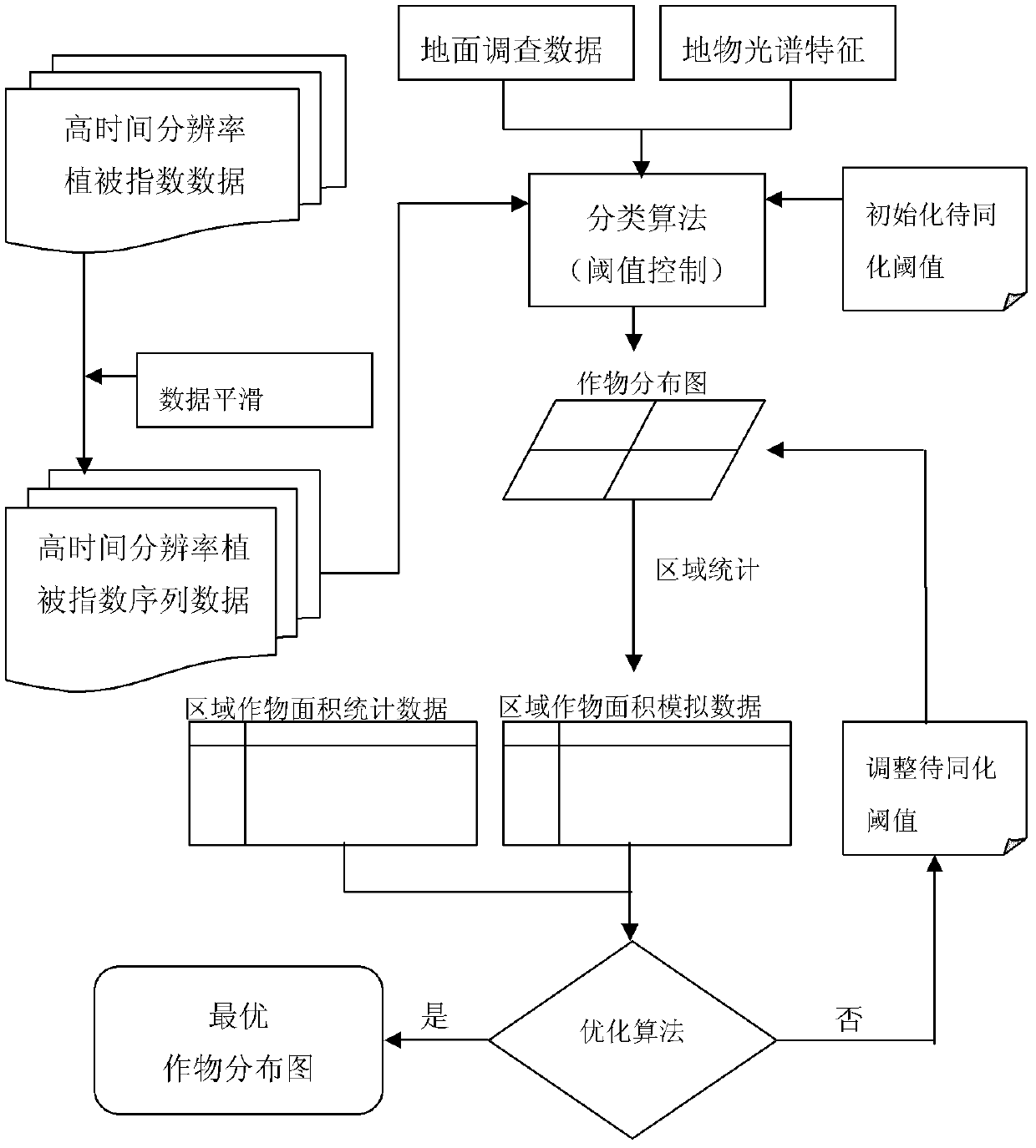
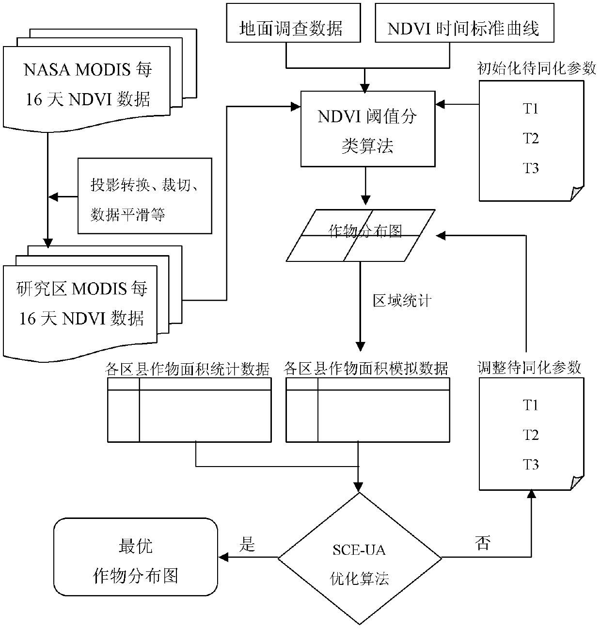
[0049] The invention is a method for optimizing spatial distribution of crop area statistical data under the support of time series data composed of high time resolution remote sensing vegetation index. Since the growth of vegetation takes years as a cycle, different vegetation types have their own phenological rhythms of growth, decline and withering in this growth cycle, showing different growth laws, and the regularity is extremely strong. This regularity can be used as a starting point for vegetation classification. Crop growth cycle has its own unique growth rules (such as sowing, emergence, rising, jointing, heading, milk ripening, harvesting, etc.), but there are certain differences in the internal structure of leaves of different crops. Therefore, there will be some differences in the phenological periods of different crops, resulting in different spectral shape time curves of different crops, but the same crop has a relatively stable crop growth and development law an...


PUM


Abstract

The invention provides a method for optimizing the spatial distribution of statistical data about a crop planting area. The method comprises the following steps of: (A), collecting a crop remote sensing image and the statistical data about the crop planting area within an administrative unit, and preprocessing the crop remote sensing image; (B), selecting a target crop from the crop remote sensing image, and establishing a standard curve about the exponential-time sequence characteristics of the target crop within a certain area; (C), determining the phenological information of the crop by utilizing the standard curve about the exponential-time sequence characteristics of the crop, and determining a crop classification algorithm model according to the phenological information of the crop; (D), calculating an optimum value of a characteristic parameter of the crop classification algorithm model according to agricultural statistical data about the actual planting area of the crop in the area by utilizing a global optimization algorithm; and (E), substituting the optimum value of the characteristic parameter into the crop classification algorithm model to calculate the spatial distribution information of the crop planting area. Therefore, the accuracy of the spatial information of the statistical data about the crop is further improved.

Description

technical field [0001] The invention relates to an optimization method for the spatial distribution of crop planting area statistical data. Background technique [0002] Crop planting area statistics are one of the core indicators of agricultural statistics. Accurate crop planting area statistics are not only related to the correct formulation of national agricultural policies, but also have great significance for improving agricultural production management, enhancing agricultural resource monitoring capabilities, optimizing crop planting structures, accurately predicting crop yields, and ensuring national food security. In recent years, with the gradual deepening of quantitative research on a series of issues such as global climate change, population, resources, environment, ecology and food security, accurate agricultural statistics have played an important role in the research of the above issues. Among them, the statistical data of crop planting area has become one of ...

Claims


Application Information

Patent Timeline
IPC IPC(8): G06Q10/04
Inventor 任建强陈仲新唐华俊王道龙周清波王晋臣刘佳
Owner INST OF AGRI RESOURCES & REGIONAL PLANNING CHINESE ACADEMY OF AGRI SCI
Learn More