
Geometric imaging construction method for side-looking medium resolution ratio satellite

A technology of geometric imaging and construction method, which is applied in satellite radio beacon positioning systems, instruments, complex mathematical operations, etc., can solve the problems of undefined changes in orientation parameters outside the sensor, complex attitude jitter modes, and poor accuracy

Inactive Publication Date: 2012-06-20
WUHAN UNIV
View PDF4 Cites 22 Cited by
  • Summary
  • Abstract
  • Description
  • Claims
  • Application Information

AI Technical Summary

Problems solved by technology

However, the medium-resolution satellite with a large field of view using a line array sensor has a large coverage area and the influence of terrain and earth curvature on deformation and distortion. The fitting accuracy of a single polynomial is very poor, and it cannot meet the mapping needs of most cases.
At the same time, it is not suitable for affine transformation to simulate its imaging process. The application conditions of this model are limited to high-resolution satellites with long focal length and small field of view; and due to the factors of the satellite platform itself, the attitude jitter mode is more complicated, and the accuracy of satellite starting data Limited, the imaging process cannot be described by direct linear transformation model (DLT) or rational polynomial model (RFM) as geometric model
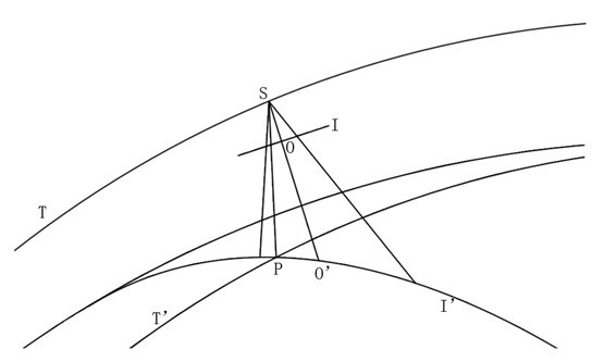
Generally, the description of wide field of view imaging can only rely on the traditional collinear equation model, but the collinear equation describing the line array sensor does not clearly define the change of the orientation parameters outside the sensor, and the description and answer of the parameter change involve the A series of data requirements such as control point distribution

Method used


Image

  • Geometric imaging construction method for side-looking medium resolution ratio satellite
  • Geometric imaging construction method for side-looking medium resolution ratio satellite
  • Geometric imaging construction method for side-looking medium resolution ratio satellite

Examples


Embodiment

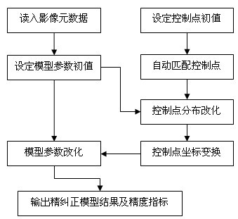
[0041] This example obtains the accuracy of the geometric model mentioned in the present invention under the premise that the satellite sensor placement matrix is ​​unknown through the wide-width side-view satellite image with satellite local orbit determination and positioning information and its and known geographic reference images. parameters, so as to provide an accurate mapping relationship for geometric fine correction. See the process figure 1 .


PUM


Abstract

The invention relates to a geometric imaging construction method for a side-looking medium resolution ratio satellite. The method comprises the following step: (1) importing satellite image metadata and satellite almanac data to determine a satellite orbit and an attitude fitting equation, parameter initial value of a datalink node and other parameter initial values; (2) automatically primarily acquiring an image control point initial value according to an image metadata containing projection information of a reference; (3) manually setting at least three control points, automatically matching image control points by gray matching, automatically providing a control point missing area, and modifying distribution of control points in the control point missing area; (4) modifying distribution of control points for which the step (3) is completed, transforming coordinates, and constructing a geometric imaging model of the satellite; (5) modifying, iterating and calculating model parameters according to the acquired parameter initial values of step (1) and the geometric imaging model of step (4); and (6) outputting the corrected model result and accuracy index.

Description

technical field [0001] The invention belongs to the field of image processing, and relates to a geometric imaging construction method for side-view medium-resolution satellites. Background technique [0002] The time and place of natural disasters always have great randomness. With the progress of modern human society, responding to natural environmental disasters quickly and in a timely manner and providing corresponding assistance are the most effective means to reduce disaster losses. Therefore, the regional The monitoring of natural disasters has become particularly important. The core way to establish a monitoring system is to establish a remote sensing satellite system with a fast response time. Today, when the low-cost small satellite constellation has become the mainstream development direction, using a few satellites with a large field of view and using side-view observation as the imaging method As the information acquisition method of the environmental disaster r...

Claims


Application Information

Patent Timeline
Patent Type & Authority Applications(China)
IPC IPC(8): G01S19/00G06F17/10
Inventor 潘励何潇
Owner WUHAN UNIV
Learn More