Method for automatically drawing river water surface line by utilizing multiple remote control water level detection devices

A detection device and automatic drawing technology, which is applied in the direction of displaying liquid level indicators through pressure measurement, can solve the problems of parameter changes, complex water surface lines, etc., and achieve the effects of ensuring equipment voltage, saving energy, and avoiding theft

Active Publication Date: 2013-02-06
广西远长公路桥梁工程有限公司
View PDF4 Cites 0 Cited by
  • Summary
  • Abstract
  • Description
  • Claims
  • Application Information

AI Technical Summary

Problems solved by technology

[0005] However, due to differences in information such as seasons, water levels, and river beds, the parameters will vary greatly. It is quite complicated to calculate the water surface line of the entire river based on the water level information at a certain point.

Method used


Image

  • Method for automatically drawing river water surface line by utilizing multiple remote control water level detection devices
  • Method for automatically drawing river water surface line by utilizing multiple remote control water level detection devices
  • Method for automatically drawing river water surface line by utilizing multiple remote control water level detection devices

Examples


Embodiment 1

[0050] The present invention will be further described below in conjunction with the accompanying drawings and specific embodiments.

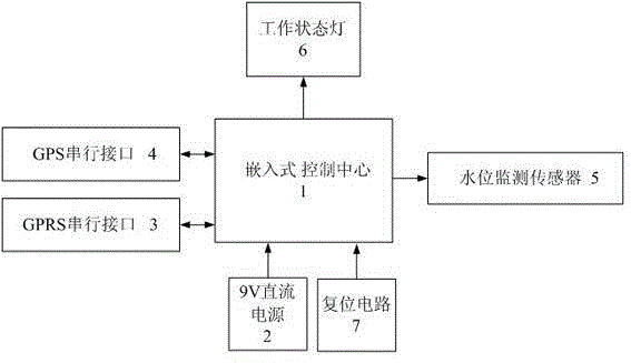
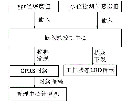
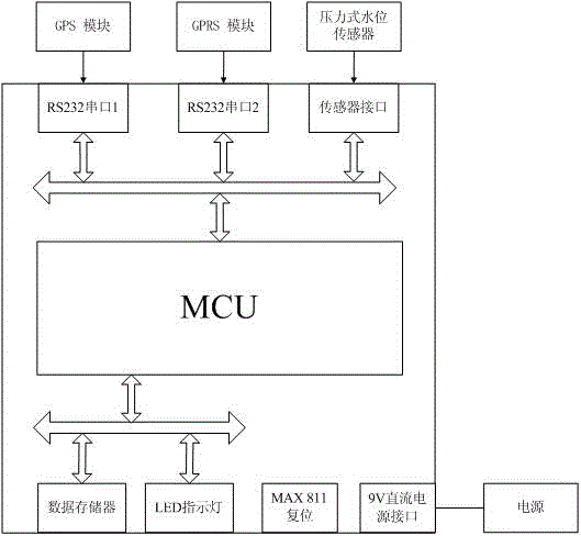
[0051] 1. Reference figure 1 , a method for automatically drawing the water surface line of a river by using multiple water level telemetry detection devices. module (3.), GPS module (4), water level pressure sensor (5), remote management center computer (6), and its working steps are as follows:

[0052] a. The device is packaged in a metal box and connected to the water level sensor and solar power supply through a shielded cable.

[0053] b. The embedded control center is connected to the working power supply module. After the power supply, the embedded control center starts to work, circularly detects the changes of various module parameters, calculates and analyzes the detection results and sends the information to the remote management center computer, and at the same time receives the remote management center computer. Control instruc...


PUM


Abstract

The invention discloses a method for automatically drawing a river water surface line by utilizing a plurality of remote control water level detection devices. The method comprises the following steps of: installing the plurality of remote control water level detection devices on a river section; acquiring, analyzing and storing water level sensor data and global positioning system (GPS) position data by using the remote control water level detection devices; connecting the remote control water level detection devices with a management center computer through a general packet radio service (GPRS) module in a wireless connection mode, and transmitting water level data and the GPS data to the management centre computer; installing data receiving supporting software in the management centre computer, receiving the information uploaded by the remote control water level detection devices in real time and storing the information in a database; and installing data processing supporting software in the management centre computer, taking latest data out from the database periodically and analyzing and calculating the latest data to obtain water surface data of the overall river, and drawing the river water surface line according to the data. By the method, the remote real-time monitoring of river water level for navigational matter departments and water conservancy departments is facilitated; and the method plays a very important role in flood protection by comparing the obtained water surface line with a river bank line.

Description

technical field [0001] The invention relates to a method for calculating the water surface line of a river with a computer, especially a method for automatically calculating the water surface line of a river with an automatic telemetering device for water level, and the technical field of providing water regime information for flood control and shipping. technical background [0002] The water surface line of a natural river is a line connecting the elevations of each section along the free water surface of a river. Calculating the water surface line of a natural river is a classic problem in hydraulics, and it is of great significance for river flood control and reservoir inundation. At present, the method of calculating the water surface line of natural river generally adopts the energy method. The premise of this method is to assume that the flow state of the calculated river section conforms to the shape of gradual flow, and the hydraulic elements change slowly with time...

Claims


Application Information

Patent Timeline
Patent Type & Authority Patents(China)
IPC IPC(8): G01F23/14
Inventor 陈向进李文勇崔更申
Owner 广西远长公路桥梁工程有限公司
Why Eureka
Try Eureka