
Automatic simulation method of natural-color products of high-space-resolution remote sensing images

A technology of remote sensing image and simulation method, which is applied in the direction of character and pattern recognition, instruments, computer components, etc. It can solve the problems of post-processing manual map adjustment workload, model lack of image analysis, true color color distortion, etc., and achieve saving The effect of manual color correction time, true color, and small spectral distortion

Inactive Publication Date: 2011-10-19
REMOTE SENSING APPLIED INST CHINESE ACAD OF SCI
View PDF2 Cites 14 Cited by
  • Summary
  • Abstract
  • Description
  • Claims
  • Application Information

AI Technical Summary

Problems solved by technology

The model lacks image analysis, the simulated true-color color distortion is serious, the color tone is unnatural, and the post-processing manual image adjustment workload is heavy

Method used


Image

  • Automatic simulation method of natural-color products of high-space-resolution remote sensing images
  • Automatic simulation method of natural-color products of high-space-resolution remote sensing images
  • Automatic simulation method of natural-color products of high-space-resolution remote sensing images

Examples


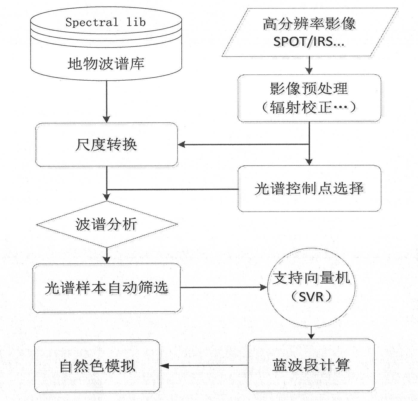
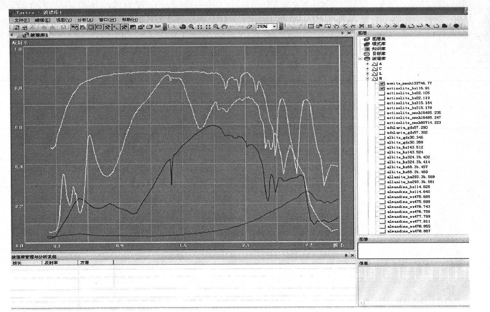
Embodiment Construction

[0027] The present invention will be described in detail below in conjunction with accompanying drawings and experimental cases.

[0028] figure 1 It is the overall technical process of true color simulation of remote sensing images, in which the ground object spectral library data is integrated with the USGS global ground object spectral library version 6 (speclib06), ENVI's built-in ground object spectral library data and some typical field measurements spectral data. In order to facilitate the unified management and standardized use of existing spectral data, we have established a set of spectral library management system based on the existing ground object spectral data and relying on the development environment of VC++. figure 2 The main interface of the spectral library management system is displayed, the horizontal axis represents the wavelength, and the vertical axis represents the reflectivity. The system can realize the management, visual query and display of surf...


PUM


Abstract

The invention provides a simulation method of natural colors of high-resolution remote sensing images based on field spectroscopic data; especially for high-resolution remote sensing images without blue-light waveband (such as SPOT, IRS and the like), the difficulty of natural color synthesis of the images can be solved by simulation of the blue-light wave band. The simulation method comprises the steps of: firstly, preprocessing the field object wave spectrum data according to wavelength bandwidth setting of images to be simulated and a spectrum response function; then selecting control points of spectrum samples automatically according to the cluster result of ISODATA (iterative self-organizing data) algorithm, and selecting spectrum candidate samples by a spectral matching algorithm; next, learning and training by using a support vector machine to construct a nonlinear relation model among the blue-light wavebands to be simulated and known wavebands; and finally, realizing calculation of the blue-light wavebands according to the nonlinear relation model (SVM). The simulated natural-color image product is natural in color tone and real in color, and can be used in multiple fields, the automatic simulation of the missing blue-light wavebands of the high-space-resolution remote sensing images and the making of natural-color images are realized and the workload of manual image adjustment is greatly reduced.

Description

technical field [0001] The invention relates to a remote sensing image processing technology and a remote sensing image simulation and enhancement method. Specifically, it relates to data preprocessing, data simulation and spectral relationship mining, and the invention is applicable to medium and high resolution remote sensing image data simulation and production of true color image data products. Background technique [0002] Due to the characteristics that the blue band is more likely to be scattered in radiation transmission and the sensor design technology, the blue band signal received by the sensor is relatively weak, and even some high spatial resolution multispectral sensors do not have a blue light channel (for example; SPOT, IRS, etc.), so that users encounter difficulties in synthesizing true-color images during the application process. For this reason, many scholars and research institutions at home and abroad have carried out a series of research on true color...

Claims


Application Information

Patent Timeline
Patent Type & Authority Applications(China)
IPC IPC(8): G06K9/66
Inventor 朱长明骆剑承沈占锋程熙郜丽静
Owner REMOTE SENSING APPLIED INST CHINESE ACAD OF SCI
Learn More