
Global positioning system (GPS)/global navigation satellite system (GLONASS) dual-system combination simulator and method

A simulation method and dual-system technology, applied in the field of satellite navigation, to achieve the effect of reducing errors, shortening the research and development cycle, and facilitating construction

Inactive Publication Date: 2011-09-07
GUILIN UNIV OF ELECTRONIC TECH
View PDF4 Cites 23 Cited by
  • Summary
  • Abstract
  • Description
  • Claims
  • Application Information

AI Technical Summary

Problems solved by technology

[0004] The technical problem to be solved by the present invention is to provide a GPS and GLONASS dual-system combined simulator and method, which mainly overcomes the gap between GPS and GLONASS two systems by solving the coordinate system, time system, and timing synchronization problems between GPS and GLONASS systems. The difference between them, so that the GPS and GLONASS satellite signals received by a carrier at the same time and space can be simulated at the same time

Method used


Image

  • Global positioning system (GPS)/global navigation satellite system (GLONASS) dual-system combination simulator and method
  • Global positioning system (GPS)/global navigation satellite system (GLONASS) dual-system combination simulator and method

Examples


Embodiment Construction

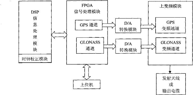
[0034] The present invention is a GPS and GLONASS dual system combined simulator such as figure 1 As shown, the hardware part is mainly composed of a host computer and an analog hardware platform. The analog hardware platform includes a baseband signal processing module composed of a DSP information processing module and an FPGA signal processing module, two D / A conversion modules, an up-conversion module, And the transmitting antenna or output cable. The host computer is connected to the FPGA signal processing module of the baseband signal processing module through the serial port, and the FPGA signal processing module of the baseband signal processing module is connected to the up-conversion module through the D / A conversion module to the transmitting antenna or output cable. The DSP information processing module of the baseband signal processing module is connected to the FPGA signal processing module. Among them, the FPGA signal processing module is equipped with a GPS cha...


PUM


Abstract

The invention discloses a global positioning system (GPS) / global navigation satellite system (GLONASS) dual-system combination simulator and a GPS / GLONASS dual-system combination simulation method. Based on a hardware platform consisting of a digital signal processor (DSP) information processing module, a field programmable gate array (FPGA) signal processing module, two D / A conversion modules, an up-conversion module and a transmission antenna or output cable, a GPS satellite channel and a GLONASS satellite channel which are independent of each other are separated to realize GPS / GLONASS dual-system combination simulation. In the simulator and the simulation method, not only an independent GPS satellite signal and an independent GLONASS satellite signal can be simulated in an independent processing way, but also the coordinate system uniformization and time system synchronization of two systems can be realized, thereby effectively shortening a research and development cycle, reducing the receiver research and development cost and bringing convenience to the construction of a testing environment.

Description

Technical field [0001] The invention relates to the field of satellite navigation, in particular to a GPS and GLONASS dual system combined simulator and method. Background technique [0002] GNSS (Global Navigation Satellite System), or "Global Navigation Satellite System", is the collective name for satellite navigation systems, including GPS in the United States, GLONASS in Russia, Compass in China, and Galileo in the European Union. The number of available satellites will be Reach more than 100 pieces. As far as the current situation is concerned, there are mainly two global satellite navigation and positioning systems that have been built and put into operation, one is the US GPS global satellite positioning system, and the other is the Russian GLONASS system. They can provide services such as precise positioning for unlimited users around the world around the clock. GPS and GLONASS are two completely independent systems. When in normal operation, the positioning performanc...

Claims


Application Information

Patent Timeline
Patent Type & Authority Applications(China)
IPC IPC(8): G01S19/23
Inventor 孙希延纪元法施浒立蔡成林孙希刚符强
Owner GUILIN UNIV OF ELECTRONIC TECH
Learn More