Method for geographic information-oriented management of MOCA equipment
A technology of information management and geographic information, applied in the field of geographic information management of MOCA equipment, can solve the problem that system equipment cannot mark its information, judge the fault of MOCA equipment, etc., to improve management efficiency and maintenance efficiency, and save operating expenses. Effect
- Summary
- Abstract
- Description
- Claims
- Application Information
AI Technical Summary
Problems solved by technology
Method used
Image
Examples
Embodiment 1
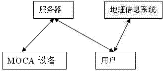
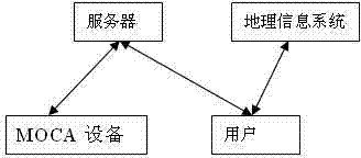
[0029] Embodiment one, see figure 1 , the geographical information management method of MOCA equipment, including the following steps:
[0030] Step 1. Geographical information labeling: through applications such as IE or WEB, the server submits the geographical information of the device when the MOCA device is installed; the geographical information of the MOCA device includes the address, zip code, longitude, latitude, altitude and physical map of the MOCA device, of which the physical map Maps include vector maps, satellite images, etc.; equipment location information such as latitude and longitude, address, and altitude are stored in the local server and submitted by the user. Physical maps such as vector maps and satellite maps are stored by the geographic information server. The tripartite can also be local.
[0031] Step 2, MOCA device registration: After the MOCA device is initialized, it will regularly submit device registration information to the server through IP a...
Embodiment 2
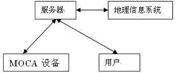
[0040] Embodiment two, see figure 2 , the geographical information management method of MOCA equipment, including the following steps:
[0041] Step 1. Geographical information labeling: through applications such as IE or WEB, the server submits the geographical information of the device when the MOCA device is installed; the geographical information of the MOCA device includes the address, zip code, longitude, latitude and altitude of the MOCA device and the physical map, of which the physical map Maps include vector maps, satellite images, etc.; equipment location information such as latitude and longitude, address, and altitude are stored in the local server and submitted by the user. Physical maps such as vector maps and satellite maps are stored by the geographic information server. The tripartite can also be local.
[0042] Step 2. MOCA device registration: After the MOCA device is initialized, it will submit the device registration information to the server through IP...
PUM
 Abstract
Description
Claims
Application Information
 - R&D
- Intellectual Property
- Life Sciences
- Materials
- Tech Scout
- Unparalleled Data Quality
- Higher Quality Content
- 60% Fewer Hallucinations
Browse by: Latest US Patents, China's latest patents, Technical Efficacy Thesaurus, Application Domain, Technology Topic, Popular Technical Reports.
© 2025 PatSnap. All rights reserved.Legal|Privacy policy|Modern Slavery Act Transparency Statement|Sitemap|About US| Contact US: help@patsnap.com


