
Spectral reflectance peak decomposition based quantitative inversion method of mineral content by hyperspectral remote sensing

A technology of hyperspectral remote sensing and spectral decomposition, which is applied in the field of quantitative inversion of mineral content in hyperspectral remote sensing, and can solve the problems of difficult application of mineral identification methods.

Inactive Publication Date: 2011-11-09
CHINA AERO GEOPHYSICAL SURVEY & REMOTE SENSING CENT FOR LAND & RESOURCES +1
View PDF0 Cites 2 Cited by
  • Summary
  • Abstract
  • Description
  • Claims
  • Application Information

AI Technical Summary

Problems solved by technology

[0004] China's Chang'e-1 lunar exploration satellite carries a hyperspectrometer, that is, a spectrometer that does not cover the absorption spectrum of minerals to be identified. Orthopyroxene, clinopyroxene, ilmenite) have a main absorption spectrum of 0.8-2.0 μm, and the commonly used mineral identification methods based on absorption spectrum are difficult to apply

Method used


Image

  • Spectral reflectance peak decomposition based quantitative inversion method of mineral content by hyperspectral remote sensing
  • Spectral reflectance peak decomposition based quantitative inversion method of mineral content by hyperspectral remote sensing
  • Spectral reflectance peak decomposition based quantitative inversion method of mineral content by hyperspectral remote sensing

Examples


Embodiment Construction

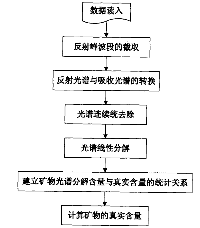
[0051] See figure 1 , in order to better illustrate the hyperspectral remote sensing mineral content quantitative inversion method based on spectral reflection peak decomposition of the present invention, a mixed system composed of four minerals, olivine, clinopyroxene, orthopyroxene, and plagioclase, was used for experiments .

[0052] (1) The equipment used in the test is a workstation, the specification model is Dell Precision 4700, the operating system is WindowsXP (64-bit), the CPU is 2.66GHz, the content is 32GB, and the hard disk is 1T.

[0053] (2) The specific steps are as follows:

[0054] Step 1, read the reflectance spectrum of the mixed system composed of four minerals (a total of 43 mixed spectra), and the end members of the four minerals (olivine, clinopyroxene, orthopyroxene, plagioclase) spectrum.

[0055] Step 2, intercepting the reflection spectrum in the 0.48-0.96 μm spectrum segment as the reflection peak spectrum segment of olivine, clinopyroxene, orth...


PUM


Abstract

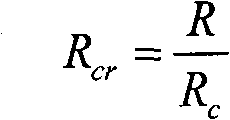
The invention relates to a spectral reflectance peak decomposition based quantitative inversion method of the hyperspectral remote sensing mineral content. The method comprises the seven steps of: 1. reading data in; 2. intercepting a reflection peak band; 3. converting a reflectance spectrum and an absorption spectrum; 4. carrying out continuum removal on the spectrums; 5. linearly decomposing the spectrums to obtain the mineral spectrum decomposition content; 6. establishing a statistical relationship between the mineral spectrum decomposition content and the real content; and 7. convertingthe calculated mineral spectrum decomposition content in the step 5 into the real mineral content according to the established statistical relationship in the step 6. The invention can not only be applied to hyperspectral data which is not covered by a mineral absorption spectrum band, but also can be used for hyperspectral data which is covered by the mineral absorption spectrum band in the spectrum band range, carries out quantitative mineral content inversion by comprehensively applying a spectral reflectance peak and an absorption spectrum band and improves the inversion precision and theinversion accuracy. The invention has practical value and broad application potential in the field of hyperspectral remote sensing mineral identification.

Description

(1) Technical field [0001] The invention relates to a hyperspectral remote sensing mineral content quantitative inversion method based on spectral reflection peak decomposition, which belongs to the field of hyperspectral remote sensing mineral identification and is suitable for quantitatively identifying mineral composition and content in rocks or soils using hyperspectral remote sensing data. (2) Background technology [0002] Hyperspectral remote sensing has the characteristics of map-spectrum integration, and can identify mineral information based on the fine spectral characteristics of minerals. At present, hyperspectral remote sensing mineral identification is divided into qualitative identification and quantitative identification. There are two main types of methods for qualitative identification—identification methods based on spectral expert knowledge and identification methods based on spectral similarity algorithms. The method of quantitative identification takes...

Claims


Application Information

Patent Timeline
Patent Type & Authority Patents(China)
IPC IPC(8): G01N21/25G01N21/31
Inventor 闫柏琨甘甫平王润生
Owner CHINA AERO GEOPHYSICAL SURVEY & REMOTE SENSING CENT FOR LAND & RESOURCES
Learn More