Vector traffic numerical map correction method based on floating car data

A floating car data and digital map technology, applied in the directions of maps/plans/charts, educational appliances, instruments, etc., can solve the problems of heavy workload, time-consuming, and influence on the accuracy of calibration point distribution and calibration, and achieves guaranteed accuracy, The effect of improving accuracy and speed

Inactive Publication Date: 2012-02-08
CHONGQING UNIV
View PDF0 Cites 0 Cited by
  • Summary
  • Abstract
  • Description
  • Claims
  • Application Information

AI Technical Summary

Problems solved by technology

[0004] Whether it is manual point-by-point correction or the traditional correction method and its improved method based on mathematical relationship correction calculation, there are certain problems: when using the manual point-by-point correction method to correct the traffic digital map, not only the workload is large (no less than the independent map), and the accuracy is easily affected by human factors; the traditional correction method using the functional relationship to correct the calculation, not only cannot correct the topology error of the vector traffic digital map, but also the functional relationship is greatly affected by the accuracy of the control points. The distribution of points also has an impact on the accuracy of the correction; using road knowledge to perform vector map correction requires on-the-spot understanding of all road conditions to ensure the accuracy of road knowledge, which is time-consuming

Method used


Image

  • Vector traffic numerical map correction method based on floating car data
  • Vector traffic numerical map correction method based on floating car data
  • Vector traffic numerical map correction method based on floating car data

Examples


Embodiment Construction

[0032] Hereinafter, preferred embodiments of the present invention will be described in detail with reference to the accompanying drawings.

[0033] The vector traffic digital map correction method based on floating car data comprises the following steps:

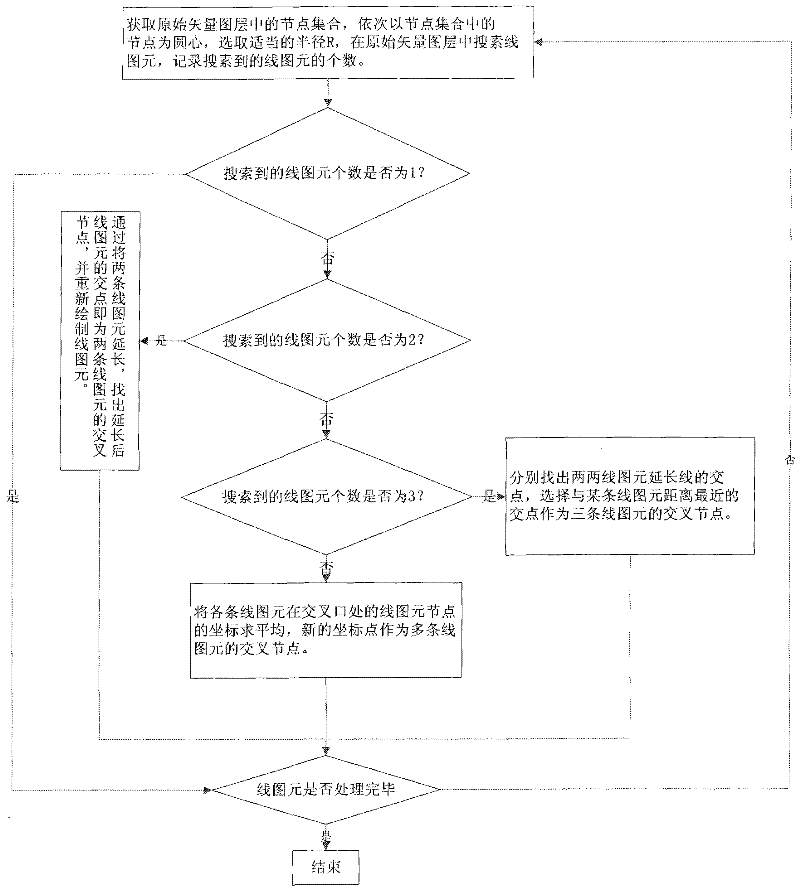
[0034] 1) Match the line graph element nodes in the original vector traffic digital map layer to correct the connectivity of adjacent line graph elements; see figure 1 , including the following steps:

[0035] 11) Obtain the line graphic element node set in the original traffic digital map layer, take the line graphic element node in the line graphic element node set as the center of the circle in turn, set the radius R, the determination of the radius R is mainly based on the accuracy of the electronic map used , set R as the maximum error value of the electronic map, so as to ensure that all relevant line primitives can be processed correctly, search for line primitives in the original traffic digital map layer within th...


PUM


Abstract

The invention relates to the technical field of traffic geographic information, in particular to a vector map correction method which can quickly, accurately and comprehensively correct road nodes forming a vector traffic numerical map. The method comprises the steps of: matching line graph element nodes in an original vector traffic numerical map layer to correct the connectedness of adjacent line graph elements; collecting locating point data by floating cars; and acquiring floating car locating point data matching with the line graph element nodes to be used as a cluster dataset by taking the matched line graph element nodes as an initial cluster center, setting a threshold value, acquiring all sample points the distances of which with the line graph element nodes are within a threshold value range, and solving the mean of the sample points to be used as a new cluster center which is a corrected line graph element node. The method corrects errors and topology errors, generated during vectorization, of the vector traffic numerical map and ensures that the connectedness and geometrical characteristic of the related line graph elements in the map correction process are not influenced.

Description

technical field [0001] The invention relates to the technical field of traffic geographic information, in particular to a method for correcting a vector map. Background technique [0002] At present, as an extension of geographic information system in the field of intelligent transportation, transportation geographic information system has been widely used in transportation planning, transportation construction and traffic management and other fields. The traffic geographic information system is an information system based on the spatial database based on the vector traffic digital map. The accuracy of the vector traffic digital map data is directly related to the performance of the traffic geographic information system. Due to various errors in the surveying and mapping process, the accuracy of the existing vector traffic digital map data is not high. Therefore, it is necessary to improve the accuracy of the vector traffic digital map data through scientific correction meth...

Claims


Application Information

Patent Timeline
Patent Type & Authority Patents(China)
IPC IPC(8): G09B29/00
Inventor 孙棣华廖孝勇刘卫宁赵敏宋伟毕俊杰
Owner CHONGQING UNIV
Why Eureka
Try Eureka