Method for accessing spatial grid object of database
A database and grid technology, applied in the information field where databases and geographic information systems intersect, can solve problems such as poor storage access efficiency, achieve poor access efficiency, improve data access efficiency, and facilitate access efficiency Effect
- Summary
- Abstract
- Description
- Claims
- Application Information
AI Technical Summary
Problems solved by technology
Method used
Image
Examples
Embodiment Construction
[0064] In conjunction with the method of the present invention, the following embodiments are provided: to the user main table T u The raster column is stored in three rows of records, corresponding to save the spatial raster object R 1 , R 2 and R 3 , the data source comes from three GeoTiff images GTiff 1 、GTiff 2 、GTiff 3 , and read with a typical data subset interception operation Subset to illustrate the entire data access process.
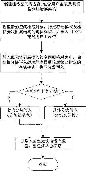
[0065] The method for importing spatial raster objects into the database proposed by the present invention, its flow is as follows figure 1 shown, including the following steps:
[0066] (1) Create a grid space table scheme Schema r ;
[0067] Create user master table T with raster columns u And its block subsidiary structure to form a grid space table scheme: Schema r ={T u ,T br ,T bf},Such as image 3 shown. in:
[0068] ①T u ={C 1 , C 2 ,...,C n , RASTER}(n≥0), is the user master table structure containing raster colum...
PUM
 Abstract
Description
Claims
Application Information
 - R&D
- Intellectual Property
- Life Sciences
- Materials
- Tech Scout
- Unparalleled Data Quality
- Higher Quality Content
- 60% Fewer Hallucinations
Browse by: Latest US Patents, China's latest patents, Technical Efficacy Thesaurus, Application Domain, Technology Topic, Popular Technical Reports.
© 2025 PatSnap. All rights reserved.Legal|Privacy policy|Modern Slavery Act Transparency Statement|Sitemap|About US| Contact US: help@patsnap.com


