
Horizontal guiding drill pipeline locus autonomous surveying and drawing location system and surveying and drawing location method thereof

A positioning system, steerable drilling technology, applied in surveying, earthwork drilling, wellbore/well components, etc., can solve problems such as errors, influence of underground pipeline detectors, and inability to actually reflect the actual position of pipelines

Inactive Publication Date: 2010-03-24
SHANGHAI MUNICIPAL ELECTRIC POWER CO +2
View PDF0 Cites 23 Cited by
  • Summary
  • Abstract
  • Description
  • Claims
  • Application Information

AI Technical Summary

Problems solved by technology

The former adopts the light source theodolite camera principle, and realizes the measurement of the attitude of the horizontal directional drilling rig through photoelectric conversion. Because the photoelectric equipment has very strict environmental requirements and low measurement accuracy, it cannot effectively meet the harsh environmental conditions of horizontal directional drilling underground construction.
The second type is to give the azimuth and inclination angle through the method of measuring the geomagnetic field. This type of instrument cannot accurately measure the attitude and position of horizontal drilling because the measurement results are easily interfered by nearby ferromagnetic substances.
Using this method, there are two problems. One is that the underground pipeline detector is easily affected by the stray electromagnetic field on the construction site, and there are large errors in the measurement. The other is that the pipeline position cannot be measured continuously, and it cannot actually reflect the actual position of the laid pipeline.

Method used


Image

  • Horizontal guiding drill pipeline locus autonomous surveying and drawing location system and surveying and drawing location method thereof
  • Horizontal guiding drill pipeline locus autonomous surveying and drawing location system and surveying and drawing location method thereof
  • Horizontal guiding drill pipeline locus autonomous surveying and drawing location system and surveying and drawing location method thereof

Examples


Embodiment approach

[0039] Such as figure 1 As shown, the present invention provides a horizontal directional drilling pipeline trajectory autonomous surveying and mapping positioning system, including the underground posture measurement system 1 'connected with the communication cable 2' and the ground data processing system 3';

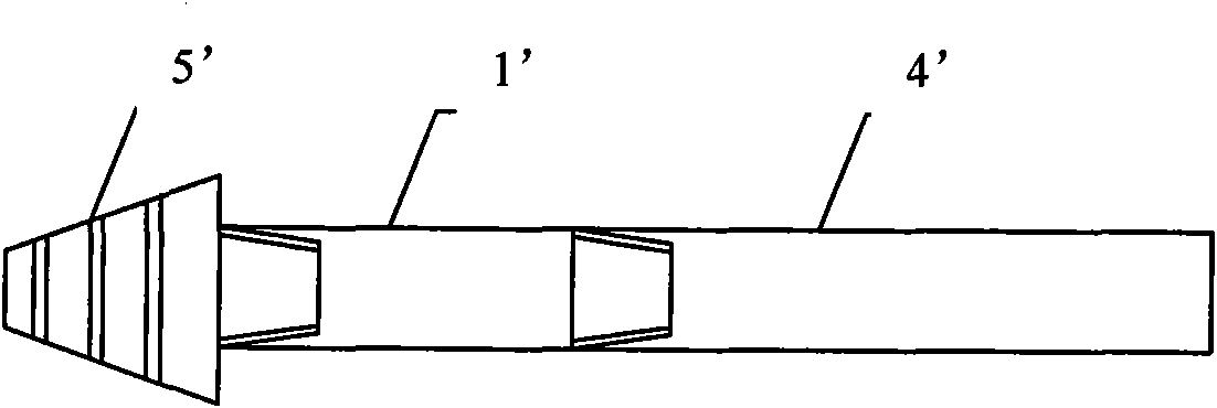
[0040] Such as figure 2 As shown, the underground attitude measurement system 1' while drilling is installed between the horizontal directional drilling drill pipe 4' and the bracket 5', or as image 3 As shown, it is installed between the horizontal directional drill rod 4' and the guide plate 6', and rotates with the horizontal directional drill rod to detect while drilling around the construction track and measure the construction posture of the horizontal directional drill in real time;

[0041] Such as Figure 4 As shown, the underground attitude measurement system 1 'includes a three-axis fiber optic gyroscope (model: NT100) 1, a three-axis accelerometer (mode...


PUM


Abstract

The invention relates to a horizontal guiding drill pipeline locus autonomous surveying and drawing location system which comprises an underground while-drilling attitude measurement system and a ground data processing system that are connected with each other by a communication cable; wherein the underground while-drilling attitude measurement system comprises a three-axis fiber optic gyro, a three-axis accelerometer, a magnetometer, an inclinometer, a data synchronization acquisition subsystem which is connected with the three-axis fiber optic gyro, the three-axis accelerometer, the magnetometer and the inclinometer by circuits, a data communication subsystem connected with the data synchronization acquisition subsystem by the circuit, and a power supply administration module respectively connected with the data synchronization acquisition subsystem and the data communication subsystem by the circuit. The system adopts inertia measurement technology, can realize accurate constructionattitude measurement for a horizontal guiding drill by arranging the horizontal guiding drill pipeline locus autonomous surveying and drawing location system between a drill rod on the horizontal guiding drill and a back-drawing device (or a guide plate) and utilizing a corresponding surveying and drawing location method, and accurately plot the exact route map of the actual construction locus.

Description

technical field [0001] The invention relates to an autonomous surveying, mapping and positioning system and a surveying, mapping and positioning method for the track of a horizontal directional drilling pipeline. Background technique [0002] Horizontal directional drill is a kind of non-excavation construction equipment for urban municipal construction. Since its construction process is "invisible", how to accurately measure and plot the construction trajectory of horizontal directional drill is an urgent problem to be solved at present. Management matters. [0003] At present, photoelectric inclinometers or electromagnetic inclinometers are used to control the construction trajectory of the horizontal directional drilling process. The former adopts the light source theodolite camera principle, and realizes the measurement of the attitude of the horizontal directional drilling rig through photoelectric conversion. Because the photoelectric equipment has very strict environ...

Claims


Application Information

Patent Timeline
Patent Type & Authority Applications(China)
IPC IPC(8): E21B47/024
Inventor 潘博朱晨沈岳翔温激鸿张永隆陈忠平瞿凯东
Owner SHANGHAI MUNICIPAL ELECTRIC POWER CO
Learn More