Laser mapping system
A laser and laser beam technology, applied in the field of laser surveying and mapping systems, can solve the problems of elevation data matching, which cannot be used to correct the elevation accuracy of photogrammetry, etc., and achieve the effect of good anti-dislocation ability and simple and compact overall structure
Inactive Publication Date: 2010-11-10
TSINGHUA UNIV
View PDF0 Cites 0 Cited by
- Summary
- Abstract
- Description
- Claims
- Application Information
AI Technical Summary
Problems solved by technology
Therefore, if the above problems are not solved, it is difficult to match the elevation data measured by laser with the position in the image, and it cannot be used to correct the elevation accuracy in photogrammetry
Method used
View moreImage
Smart ImageViewing Examples

Examples
Embodiment Construction
Login to View More PUM
 Abstract
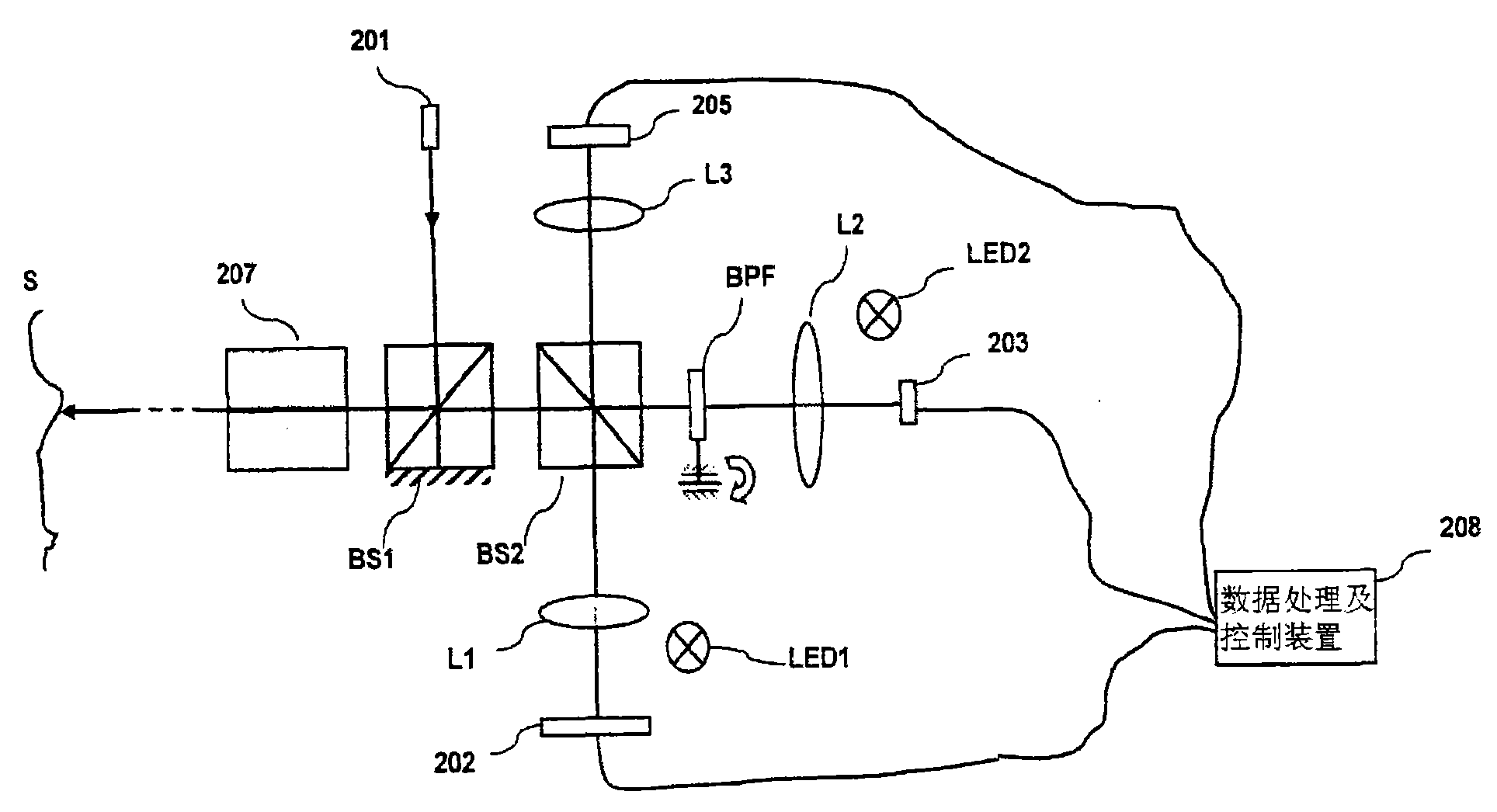
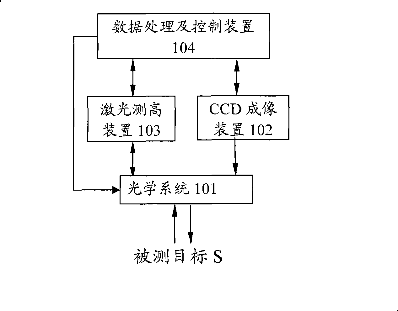
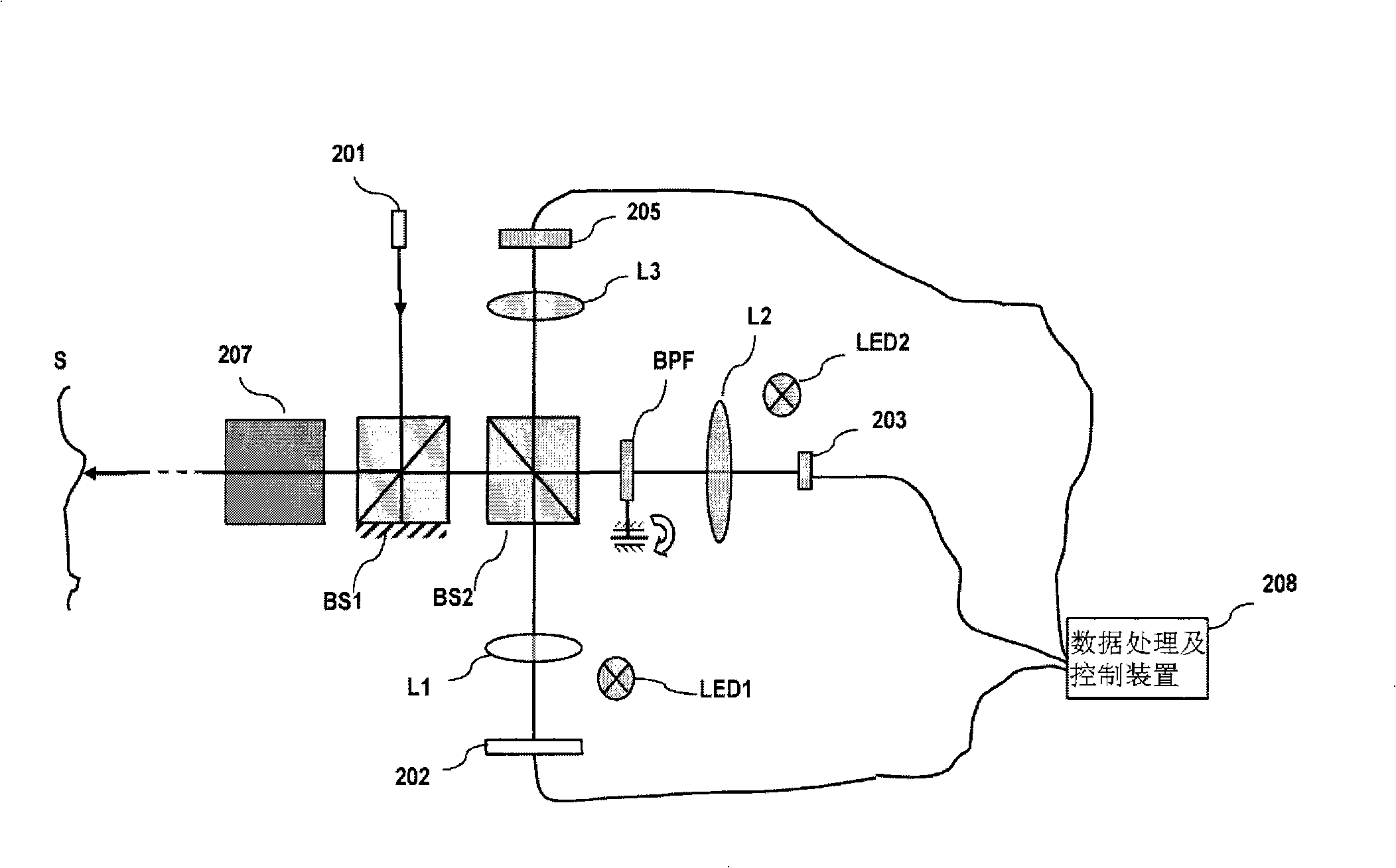
The invention provides a laser mapping system, comprising a pulse laser, a first spectroscope, a laser height measuring device containing an avalanche photodiode array unit, a linear array type charge-coupled device, an area array type charge-coupled device, a second spectroscope, a data processing and control device that receives altitude information from the laser height measuring device, push-broom image data from the linear array type charge-coupled device, images from the area array type charge-coupled device and for shooting the linear array type charge-coupled device and the avalanche photodiode array unit; both relative positions are obtained according to the images of the linear array type charge-coupled device and the avalanche photodiode array unit and then the position of a laser footprint in the push-broom image of a measured target is determined according to the relative positions and the position information of the laser footprint, thereby producing three-dimensional images of the measured target. According to the invention, the altitude error of three-dimensional images can be corrected by the altitude information, thereby realizing three-dimensional mapping systemwith higher precision and stronger anti-imbalance ability.
Description
Laser Mapping System technical field The invention relates to a laser surveying and mapping system, in particular to a laser surveying and mapping system which utilizes laser height measurement data to correct the elevation error in a three-dimensional image obtained by photogrammetry to obtain a high-precision three-dimensional topographic map. Background technique Satellite photogrammetry and laser altimeter (range finder) are two important technologies for satellite-to-earth remote sensing. Among them, satellite photogrammetry is a common technology used in topographic map surveying and mapping all over the world. In particular, with the development of technologies such as three-line array cameras in recent years, the acquisition technology of 3D remote sensing information has made great progress. Internationally, there are France's SPOT-5 satellite, India's Cartosat-1, Japan's ALOS satellite, and the United States' IKONOS satellite; my country has also successfully lau...
Claims
Login to View More Application Information
Patent Timeline
 Patent Type & Authority Patents(China)
IPC IPC(8): G01C11/00G01C5/00
Inventor 吴冠豪曾理江
Owner TSINGHUA UNIV
Features
- R&D
- Intellectual Property
- Life Sciences
- Materials
- Tech Scout
- Unparalleled Data Quality
- Higher Quality Content
- 60% Fewer Hallucinations
Learn More Browse by: Latest US Patents, China's latest patents, Technical Efficacy Thesaurus, Application Domain, Technology Topic, Popular Technical Reports.
© 2025 PatSnap. All rights reserved.Legal|Privacy policy|Modern Slavery Act Transparency Statement|Sitemap|About US| Contact US: help@patsnap.com