
Doppler aided inertial navigation

a technology of inertial navigation and aided navigation, which is applied in the direction of navigation instruments, instruments, surveying and navigation, etc., can solve the problems of meter level accuracy without deployment of support infrastructure, complexities of radio spectrum licensing, and potential interference to or from other rf systems, so as to achieve precise rf doppler observables, the effect of maximizing performance and reliability

Active Publication Date: 2016-01-19
TELECOMM SYST INC
View PDF5 Cites 7 Cited by
  • Summary
  • Abstract
  • Description
  • Claims
  • Application Information

AI Technical Summary

Benefits of technology

The present invention is advantageous in using a technique called Spectral Compression Positioning (SCP) to make the best use of multiple signals. This technique allows an SCP sensor to produce accurate data on RF communication signals even when there is no prior knowledge of existing signals. This makes performance and reliability better across a range of environments.

Problems solved by technology

Providing precise, cost-effective, and autonomous positioning information for navigating indoors or in GPS obstructed environments is a technical challenge that remains largely unsolved in consumer applications.
Advances in hybrid Wi-Fi / A-GPS positioning and inertial technologies, are showing potential, but have yet to deliver meter level accuracy without requiring deployment of support infrastructure.
For example, the very substantial cost-avoidance of deployment associated with a purpose built infrastructure for indoor positioning and particularly the complexities of radio spectrum licensing and potential for interference to or from other RF systems.

Method used


Image

  • Doppler aided inertial navigation
  • Doppler aided inertial navigation
  • Doppler aided inertial navigation

Examples


Embodiment Construction

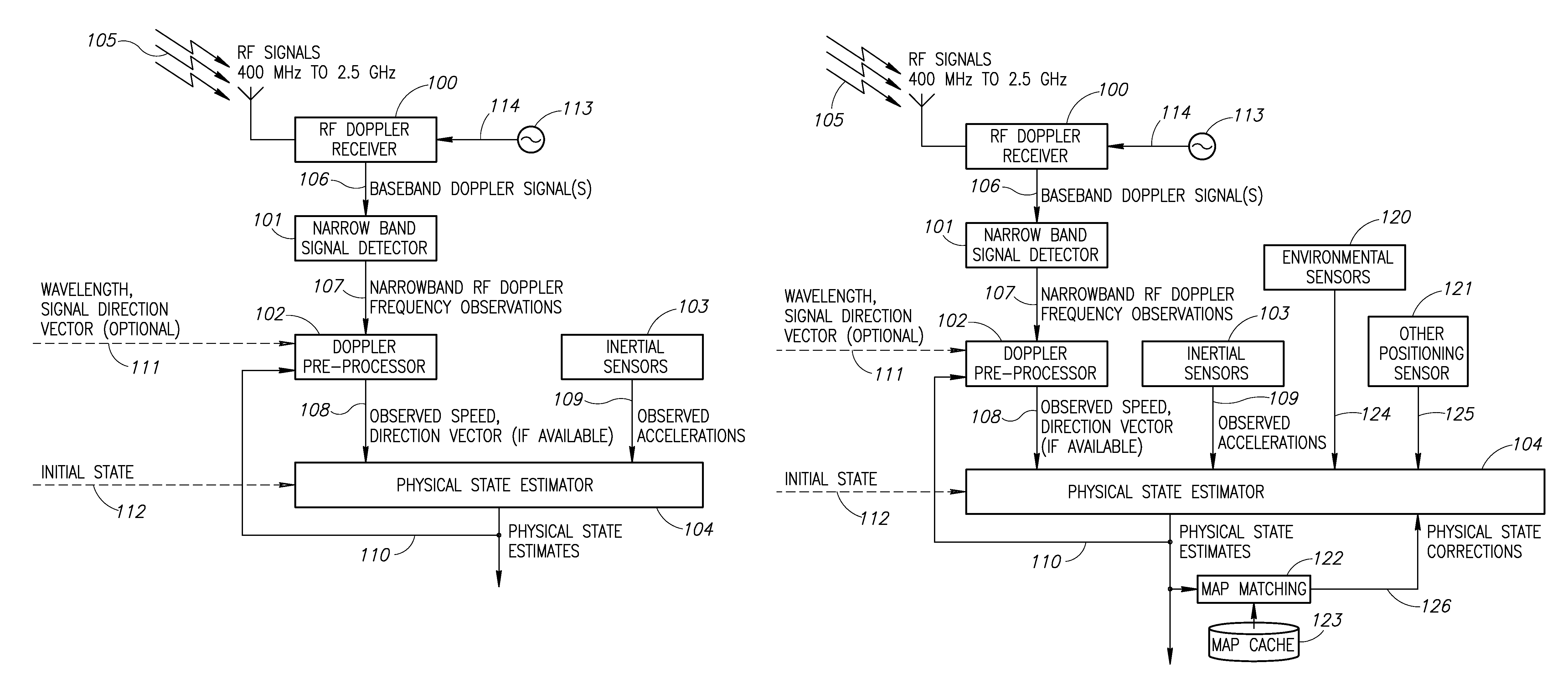
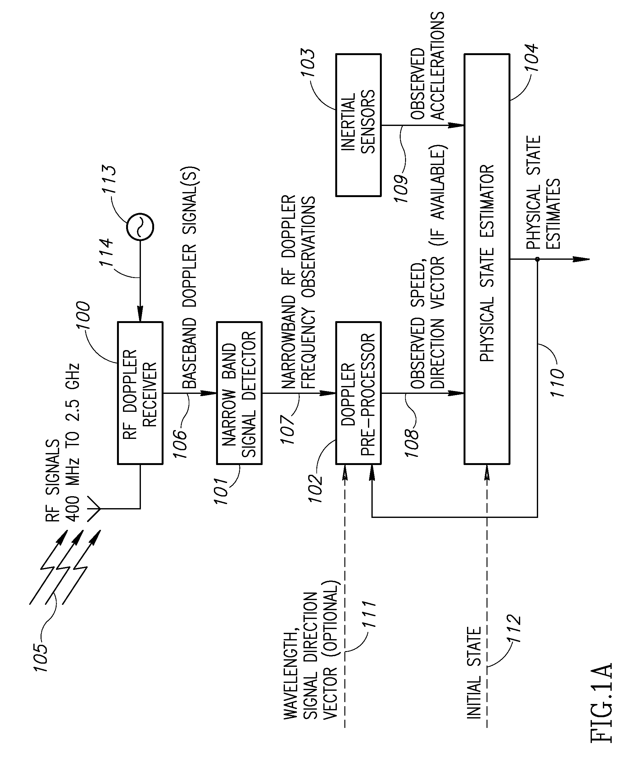
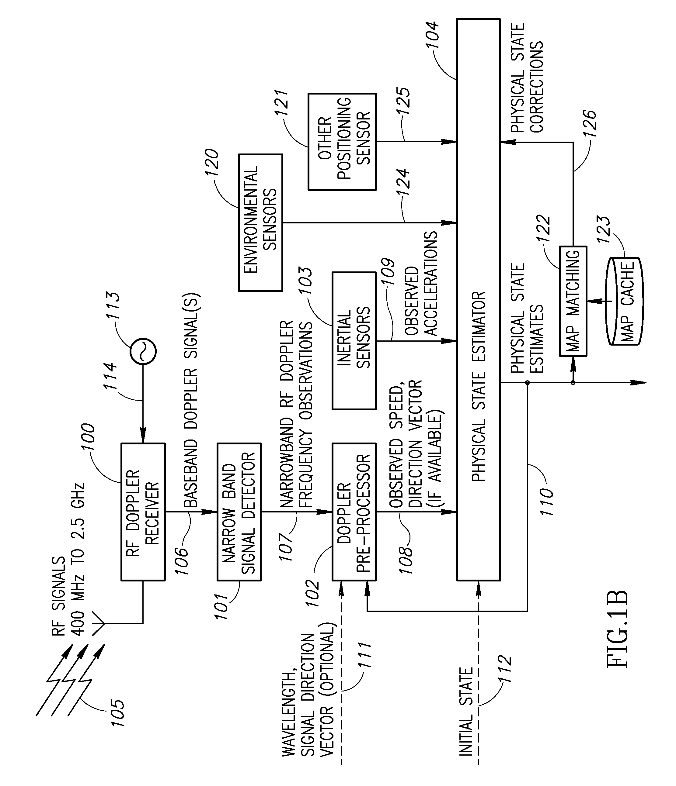
[0105]The present invention provides an alternative to GNSS coupling with inertial sensors by using other RF signals to detect speed, displacement, and potentially direction, which can be combined with inertial and other environmental sensors to produce highly precise and accurate physical state information in situations where GPS / GNSS is not available. RF signals including cellular, digital television, Wi-Fi, and other terrestrial communication signals have much better indoor penetration characteristics compared to the very weak signal GPS / GNSS. Readily available existing signals within the spectral domain of 400 MHz and 2.5 GHz can provide useful Doppler and displacement information, which can be used in conjunction with inertial data to provide position and velocity estimates for people and objects moving at relatively slow velocities. RF Doppler observables provide the functional equivalent of the ZUPT without the necessity of the full stop or additional hardware. The result is ...


PUM


Abstract

Doppler Aided Inertial Navigation (DAIN) facilitates the determination of position, velocity and direction of mobile devices operating in highly obstructed GPS / GNSS environments. Delivering high precision, high resolution positioning information using signals of opportunity, the present invention measures the Doppler shift of a moving device using a variety of signals combined with inertial accelerometers and environmental sensors to deliver an autonomous positioning and navigation capability that does not require external infrastructure or a priori knowledge of signal sources.

Description

PRIORITY CLAIM[0001]This application claims priority to U.S. Provisional Application No. 61 / 391,517, filed Oct. 8, 2010, which application is hereby incorporated by reference in its entirety as if fully set forth herein.FIELD OF THE INVENTION[0002]The invention relates to a system and method for providing precise, autonomous positioning information for navigating indoors or in GPS / GNSS obstructed environments. The invention combines high precision RF Doppler observations of readily available, existing signals with inertial and environmental sensor data to provide an autonomous positioning and navigation solution. The solution is a cost-effective approach well suited for consumer mobile wireless devices, for example, smart phones.BACKGROUND OF THE INVENTION[0003]Doppler and inertial navigation technologies have been in use in various forms since at least the 1950s when critical advances in inertial measurement and Doppler radar were achieved. These were applied successfully in aircra...

Claims


Application Information

Patent Timeline
Patent Type & Authority Patents(United States)
IPC IPC(8): G01S11/10G01C21/16G01S5/02
CPCG01C21/165G01S5/0263G01S11/10G01C21/1654
Inventor MATHEWS, MICHAEL B.MACDORAN, PETER F.
Owner TELECOMM SYST INC
Learn More