Generating radiometrically corrected surface images

a surface image and radiometric correction technology, applied in image enhancement, image analysis, instruments, etc., can solve the problems of inability to quantitative remote sensing, damage to spectral information content, and difficulty in extracting surface reflectance from aerial imagery

Inactive Publication Date: 2020-01-30
STELLENBOSCH UNIVERSITY
View PDF2 Cites 9 Cited by
  • Summary
  • Abstract
  • Description
  • Claims
  • Application Information

AI Technical Summary

Benefits of technology

The present invention provides a method for generating radiometrically corrected surface images by modelling the functional relationship between the surface image sensor measurements and the surface reflectance of a reference image using a local linear model. The method involves resampling the surface images to a higher resolution, estimating the parameters of the model using a least squares approach, and then using the estimated parameters to estimate the surface reflectance for each pixel of the surface images. The method can be carried out for each wavelength band in multi-spectral surface images. The invention also provides a system for generating radiometrically corrected surface images by receiving one or more surface images of a first resolution, providing a reference image of a second resolution, and using a modelling component to estimate the parameters of the model. The technical effect of the invention is to provide a more accurate and reliable method for generating surface images that can be used in various applications such as mapping and monitoring.

Problems solved by technology

This kind of adjustment can damage the spectral information content and is not suited to quantitative remote sensing.
Ideally quantitative analyses should be carried out on reflectance values, but extraction of surface reflectance from aerial imagery remains a challenge.
Also, spatial and temporal radiometric variations in aerial imagery limit the extent over which quantitative remote sensing techniques can be successfully applied (Markelin et al., 2012).
It is worth noting that as it is not possible or practical to correct for all the sources of radiometric variation in aerial imagery and that surface reflectance in most so-called “corrected” or “calibrated” images is only an approximation to the actual value.
While these atmospheric and BRDF correction methods are effective on single images (Markelin et al., 2012), blocks of multiple aerial images present new challenges.
Techniques that account for land cover specific BRDF's require an upfront cover classification which is time-consuming and introduces another potential source of error.
Aerial campaigns can also consist of thousands of images making it impractical to apply time consuming atmospheric and BRDF correction models to every image (López et al., 2011).
Even if it was practical, remnant radiometric variation due to the inexact nature of BRDF and atmospheric corrections will result in discontinuities, or seam lines, between adjacent images.
A disadvantage of the aerial mosaic calibration techniques described above is their complexity and need for known ground references to achieve transformation to absolute surface reflectance.
The options of placing targets of known reflectance to be captured as part of the mosaic or measuring the reflectance of suitably invariant sites on the ground are often not possible or practical.
Many applications make use of archived imagery that had been captured prior to the commencement of the research and for which concurrent ground measurements are consequently not possible.
Another approach is to make use of vicarious calibration involving knowledge of the spectral characteristics of specific ground sites, but this is recognised as being labour-intensive and costly (Chander et al., 2004; Gao et al., 2013; Liu et al., 2004).

Method used


Image

  • Generating radiometrically corrected surface images
  • Generating radiometrically corrected surface images
  • Generating radiometrically corrected surface images

Examples


Embodiment Construction

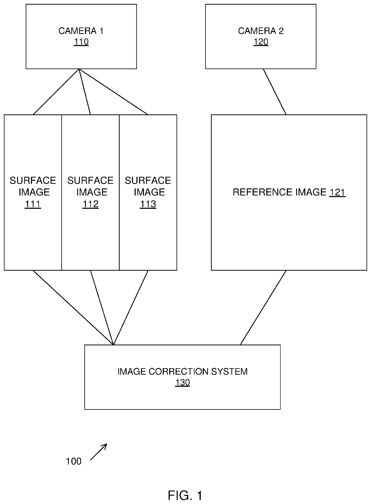
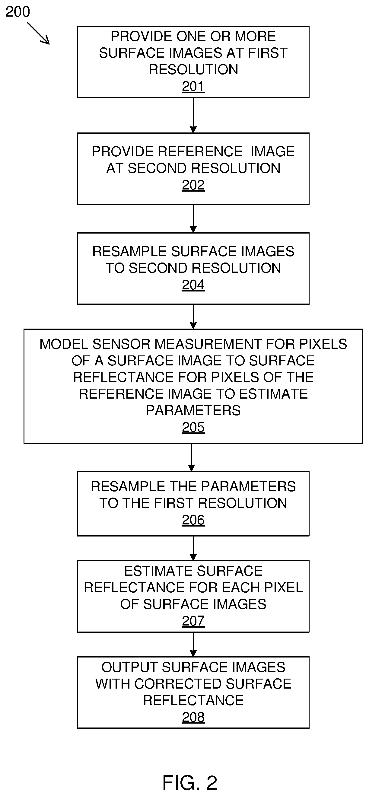
[0062]Images may be taken of the Earth's surface in the form of digital source images referred to as surface images. The surface images may include images of the surface of the Earth including ocean or vegetation surfaces, or the surface of other bodies. Such surface images may be obtained by aerial imagery, including drone imagery, or satellite imagery and may be high resolution. Mosaicking multiple surface images to cover an area results in radiometric variation over temporal and spatial extents. While very high resolution (VHR) aerial imagery holds great potential for quantitative remote sensing, its use has been limited by the unwanted radiometric variation over temporal and spatial extents. The described method and system generate radiometrically corrected surface images by using a reference image. The described method is described with multiple surface images being calibrated by a reference image; however, the method may be used to correct one surface image with the reference ...


PUM


Abstract

A system and method for generating radiometrically corrected surface images is provided. This includes providing one or more surface images of a first resolution of a surface area in the form of digital images which has a surface image sensor measurement of an intensity value of radiation in a given wavelength band reflected from the surface for each pixel of the images. A reference image of a second resolution of a corresponding surface area is provided to the surface of the surface image. The reference image has a surface reflectance for each pixel of the reference image for an equivalent wavelength band to the given wavelength band of the surface image. A functional relationship is modelled which relates the surface image sensor measurement for pixels of a surface image to the surface reflectance for pixels of the reference image to provide an estimated surface reflectance for each pixel of the surface images.

Description

CROSS-REFERENCE(S) TO RELATED APPLICATIONS[0001]This application claims priority from South African provisional patent application number 2016 / 06581 filed on 23 Sep. 2016, which is incorporated by reference herein.FIELD OF THE INVENTION[0002]This invention relates to generating radiometrically corrected surface images. In particular, it relates to correction of surface images with reference to a reference image.BACKGROUND TO THE INVENTION[0003]Very high resolution (VHR) aerial and drone imagery is increasingly being used in remote sensing studies. The high spatial resolution of these images enables analysis on a finer spatial scale than most satellite based platforms can provide and consequently allows the exploitation of information such as texture, object-based features and unmixed pixel spectra that is not available in lower resolution images (Chandelier and Martinoty, 2009; Collings et al., 2011; Honkavaara et al., 2009; López et al., 2011; Markelin et al., 2012).[0004]Accurate ...

Claims


Application Information

Patent Timeline
IPC IPC(8): G06T3/40G06T7/73G06V10/60G06V20/13
CPCG06T3/4061G06T3/4038G06T7/75G06T2207/10036G06T2207/30188G06T7/00G06T2207/10024G06T2207/10032G06V20/13G06V10/60G06T5/90
Inventor VAN NIEKERK, ADRIAANHARRIS, DUGAL JEREMY
Owner STELLENBOSCH UNIVERSITY
Why Eureka
Try Eureka