
Geographical location aggregation from multiple sources

a geo-location and multiple source technology, applied in the direction of navigation instruments, traffic control systems, instruments, etc., can solve the problems of inability to obtain reliable geo-location data from in-vehicle gps receivers, inability to block sight to four or more gps satellites in a moving vehicle, and inability to reliably locate objects. the problem of inability to accurately determine the location of objects,

Inactive Publication Date: 2015-03-12
LENNY INSURANCE LTD
View PDF3 Cites 32 Cited by
  • Summary
  • Abstract
  • Description
  • Claims
  • Application Information

AI Technical Summary

Benefits of technology

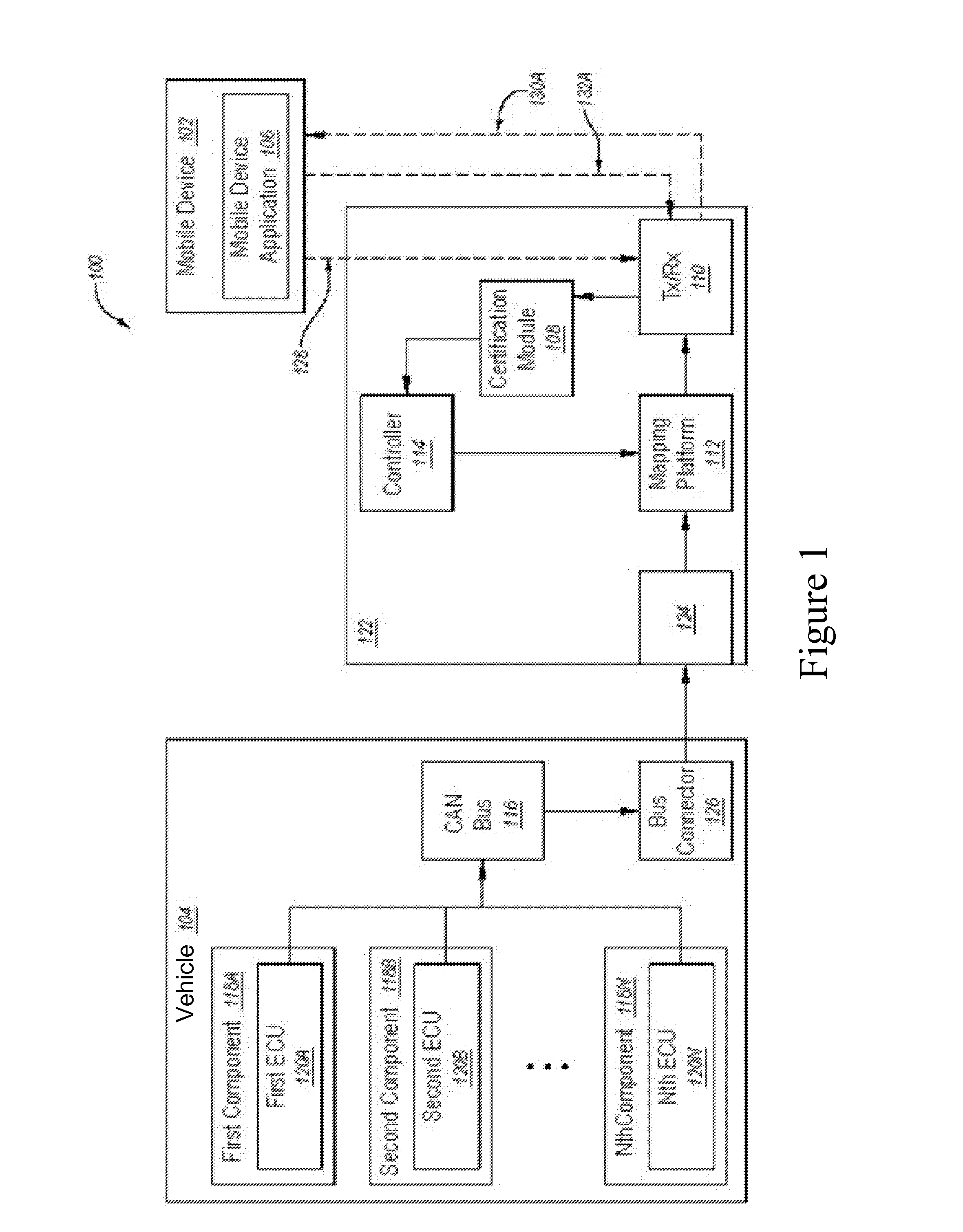
The patent describes a system and method for obtaining geographical location data from multiple sources and aggregating it. This is useful for vehicles equipped with GPS receivers, as the GPS signals may be intermittent or lost altogether in certain environments. The system uses signals communicated between electronic control units (ECUs) of the vehicle and network resources, mobile devices, and other vehicle hardware and software to obtain the geo-location data. The data is then abstracted and transmitted to the mobile device or network resource in a standardized way, allowing for the creation of mobile applications that process the data. The technical effect of this patent is to provide a reliable and standardized way to obtain geographical location data from vehicles and use it for navigation and other location-based services.

Problems solved by technology

However, an unobstructed line of sight to four or more GPS satellites in a moving vehicle is not always practical.
For example, tunnels, canyons, mountains, tall buildings, and the like can interfere with GPS signal reception.
As a result, reliable geo-location data from in-vehicle GPS receivers can be intermittent, inaccurate, or lost altogether.
In practice, this approach can provide uninterrupted, reliable navigation results in the most challenging urban environments including New York, Hong Kong, and Tokyo.
Furthermore, the gyroscope exhibits temperature-dependent characteristics and aging effects.
Thus, for a number of reasons, dead reckoning can be subject to inaccuracies.
Even when signals produced by a GPS receiver and signals produced by dead reckoning subsystems are mixed, the errors persist, particularly when the GPS data becomes intermittent, interrupted, or unreliable.
As a result, when a driver first activates the conventional GPS navigation system, the system cannot give the driver routing instructions until the vehicle is moved.
This can be frustrating for a driver who may not know the best direction to begin the route.
Conventional GPS navigation systems cannot support this functionality.
If so, the geo-location fix may be less accurate or less reliable as GPS receivers in the regional interference area may report errant or erratic geo-location data.

Method used


Image

  • Geographical location aggregation from multiple sources
  • Geographical location aggregation from multiple sources
  • Geographical location aggregation from multiple sources

Examples


Embodiment Construction

[0010]In the following description, for purposes of explanation, numerous specific details are set forth in order to provide a thorough understanding of the various embodiments. It will be evident, however, to one of ordinary skill in the art that the various embodiments may be practiced without these specific details.

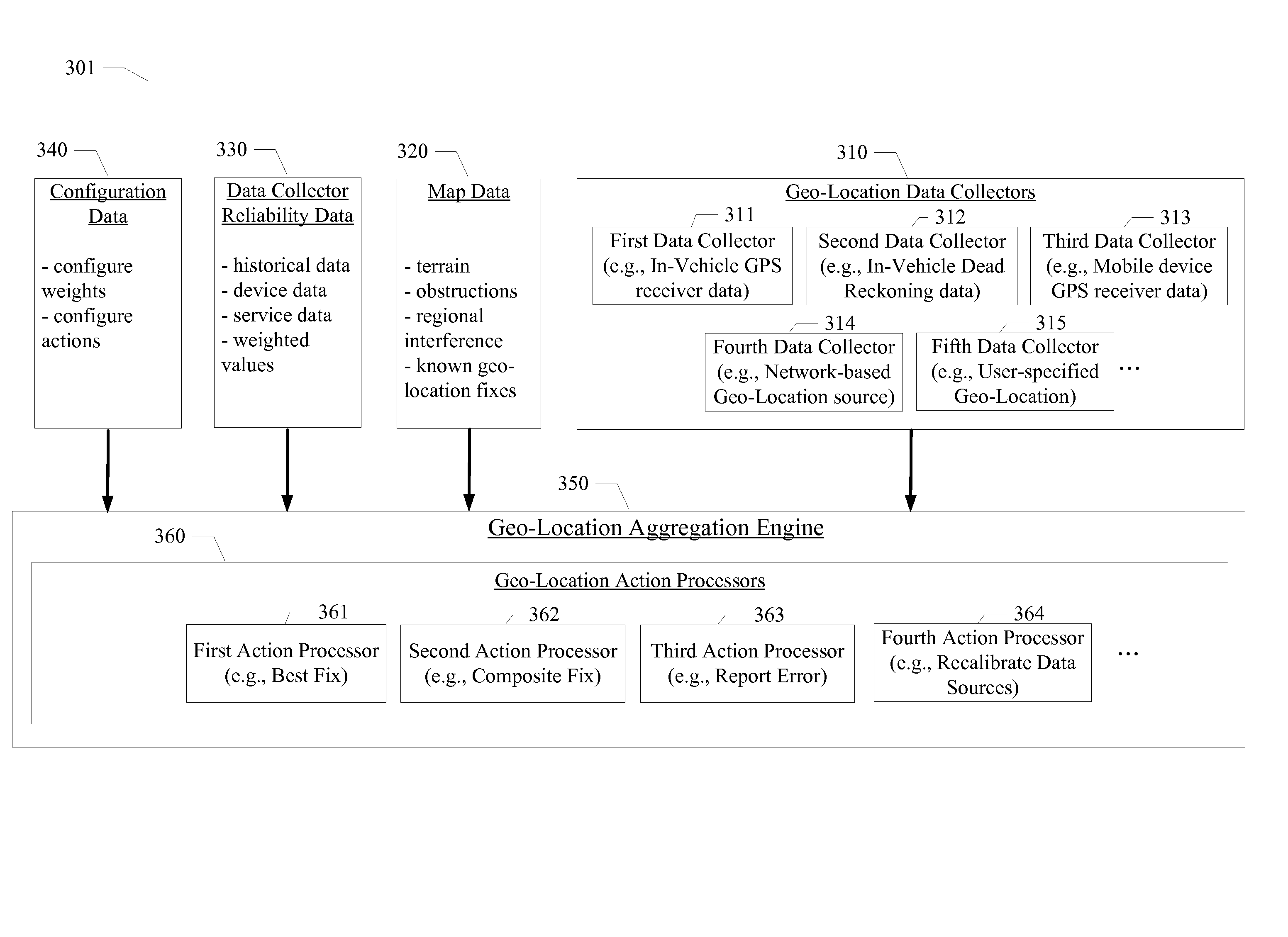
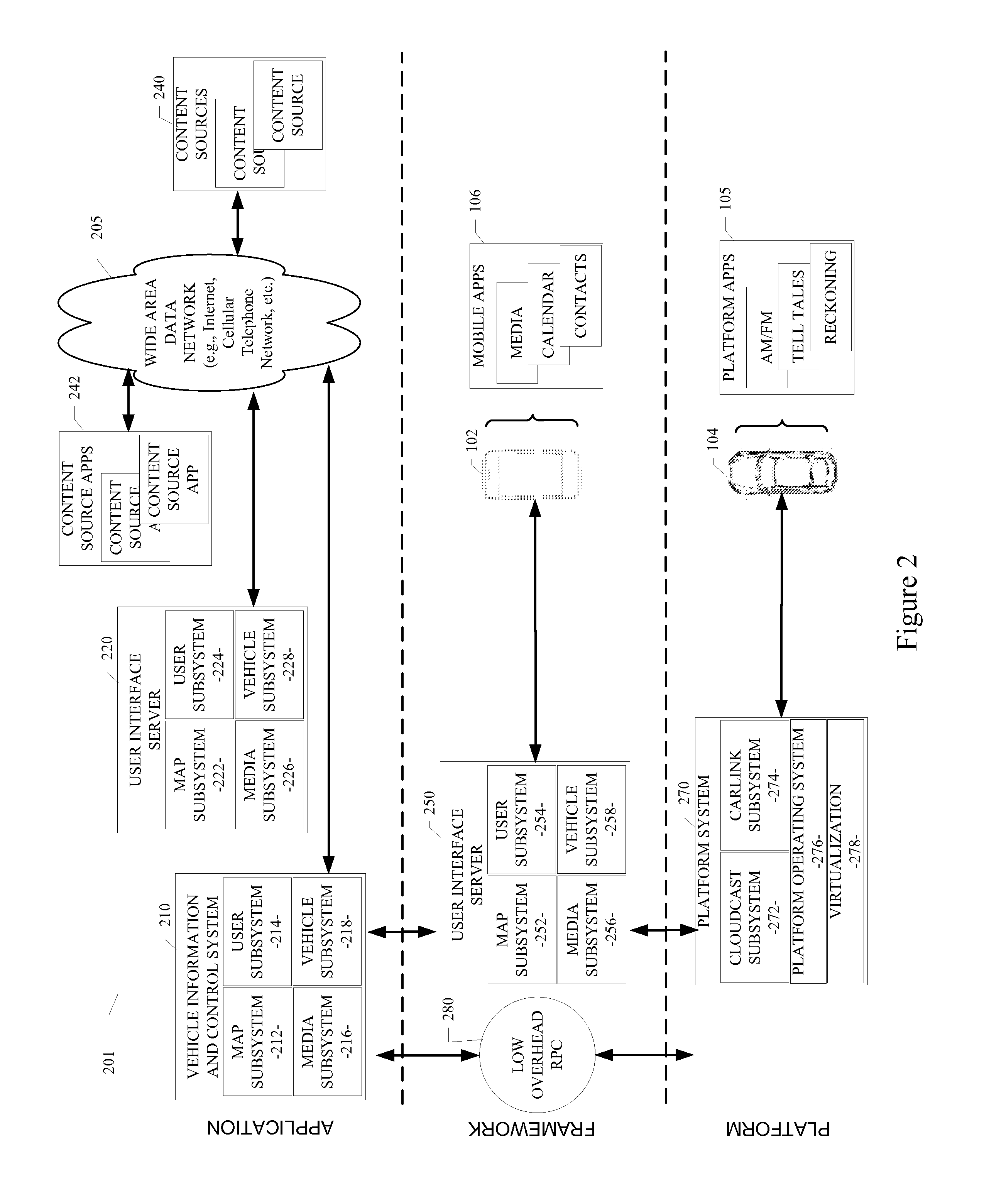
[0011]As described in various example embodiments, a system and method for obtaining geographical location data from multiple sources and aggregating the geographical location data are described herein. In one particular embodiment, a geographical location aggregation system is provided in the context of a cloud-based vehicle information and control ecosystem configured and used like the ecosystem illustrated in FIG. 2. However, it will be apparent to those of ordinary skill in the art that the geographical location aggregation system described and claimed herein can be implemented, configured, and used in a variety of other applications and systems.

[0012]Particular ex...


PUM


Abstract

Systems and methods for obtaining geographical location data from multiple sources and aggregating the geographical location data are disclosed. A particular embodiment includes: receiving geo-location data from a plurality of geo-location data collectors, at least one of the plurality of geo-location data collectors being in data communication with an in-vehicle geo-location data source, at least one of the plurality of geo-location data collectors being in data communication with a geo-location data source in a mobile device; collecting reliability data corresponding to one or more of a plurality of geo-location data sources corresponding to the plurality of geo-location data collectors; collecting map data including information related to geographical features associated with the geo-location data; and aggregating, by use of a data processor, the geo-location data from the plurality of geo-location data collectors based on the reliability data and the map data to produce a resulting geo-location fix.

Description

PRIORITY PATENT APPLICATION[0001]This is a continuation-in-part patent application of co-pending U.S. patent application Ser. No. 13 / 686,894; filed Nov. 27, 2012 by the same assignee as the present application. This present patent application draws priority from the referenced patent application. The entire disclosure of the referenced patent application is considered part of the disclosure of the present application and is hereby incorporated by reference herein in its entirety.TECHNICAL FIELD[0002]This patent document pertains generally to tools (systems, apparatuses, methodologies, computer program products, etc.) for processing geographical location data, and more particularly, but not by way of limitation, to a system and method for obtaining geographical location data from multiple sources and aggregating the geographical location data.BACKGROUND[0003]An increasing number of vehicles are being equipped with one or more independent computer and electronic processing systems. Ce...

Claims


Application Information

Patent Timeline
IPC IPC(8): G01C21/32G01C21/12G01C21/16
CPCG01C21/32G01C21/165G01C21/12G01C21/30G01S19/48G01S19/426G01C21/3841
Inventor BARRETT, PETEROTHMER, KONSTANTIN
Owner LENNY INSURANCE LTD
Learn More