Home-school Geography Curriculum, Game, and Study Aid

a geography and curriculum technology, applied in the field of homeschool geography curriculum, game and study aid, can solve the problems of presenting large-scale information, lack of multi-sensory components, and lack of comprehensive or prior art-based curriculum, and achieve the effect of enhancing retention and independence for students

Inactive Publication Date: 2013-11-21
SELF TABBY LUQUETTE
View PDF0 Cites 2 Cited by
  • Summary
  • Abstract
  • Description
  • Claims
  • Application Information

AI Technical Summary

Benefits of technology

[0008]The proposed system is comprehensive and targets the special needs of home-school environments. The design fosters independence from instructors and functions with multi-level students, allowing students of varying ages and abilities to play together. It also provides methods for self-study and immediate self-correction. Retention is enhanced through competition using visually stimulating and multi-sensory components.
[0010]This product utilizes oversized maps (approximately 3′ by 3′ or 3′ by 4′) providing visual relevance to each identified region or feature. Solid, textured manipulatives require active placement on the identified region or feature represented on the map playing surface area, thus engaging multiple senses. The game can be played alone or with as many users as desired. The product's large scale ensures comprehensiveness and relevance. The components are designed for three primary levels, novice, intermediate, and advanced, with varying sublevels of difficulties within each primary level.

Problems solved by technology

Existing or prior art does not provide a comprehensive, multi-level curriculum that engages students in hands-on, interactive play to enhance and expedite retention, while simultaneously fostering self-study and instructor independence.
Computer software can be comprehensive, but the small size and lack of multi-sensory components limit retention.
Additionally, computer programs often present geographical information in varying scales and in non-congruous partitions due to limited screen area.
Presenting large-scale information in this manner can create difficulties.
Learners may be unable to grasp the larger world picture and understand how varying geographical components relate to one another.
Furthermore, computer software is generally not interactive with multiple students simultaneously.
They are not interactive and do no promote active retention.
Board games are typically limiting in their information due to size or playing constraints and / or do not provide multi-level play or self-study.

Method used


Image

  • Home-school Geography Curriculum, Game, and Study Aid
  • Home-school Geography Curriculum, Game, and Study Aid
  • Home-school Geography Curriculum, Game, and Study Aid

Examples


Embodiment Construction

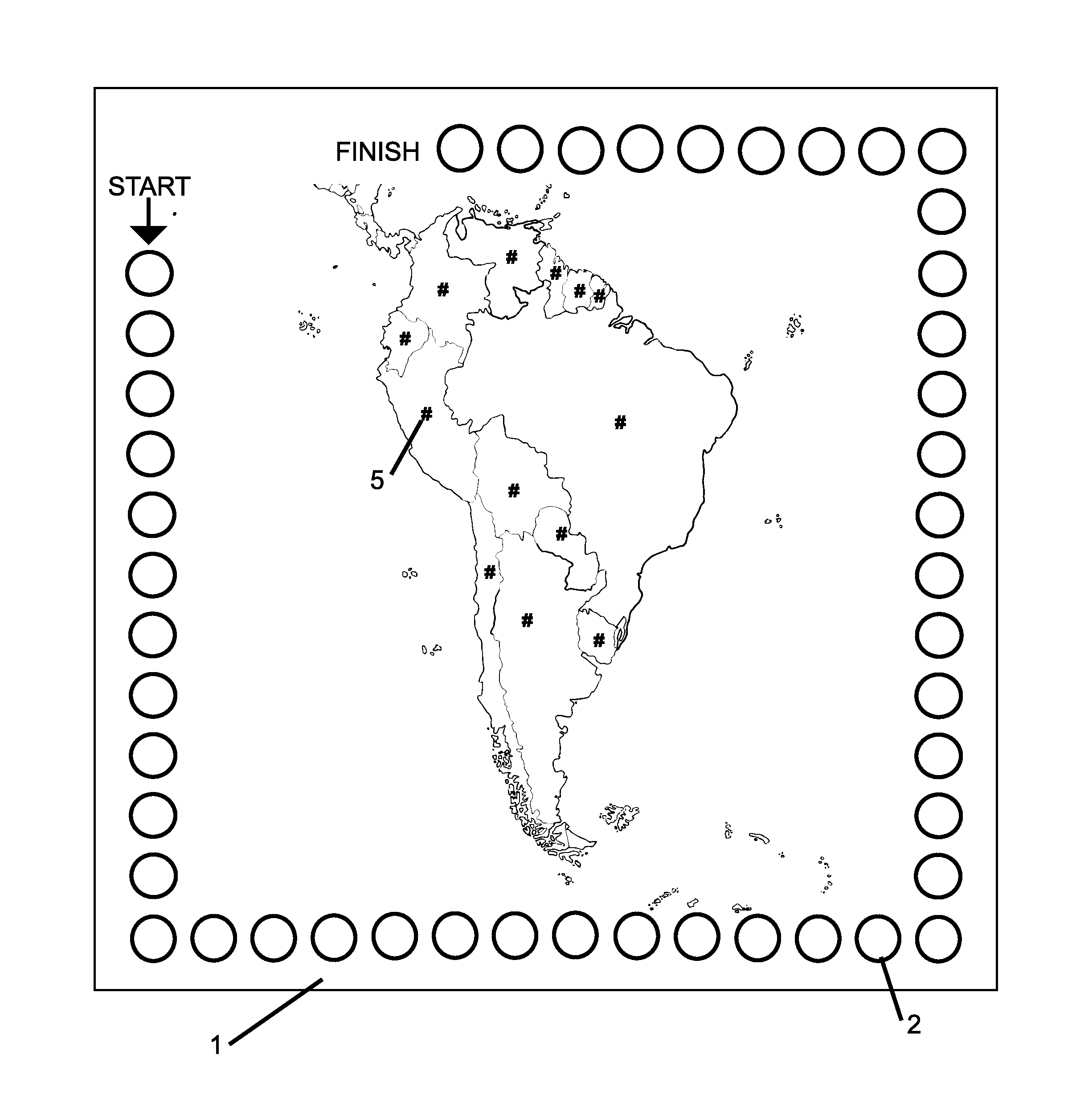
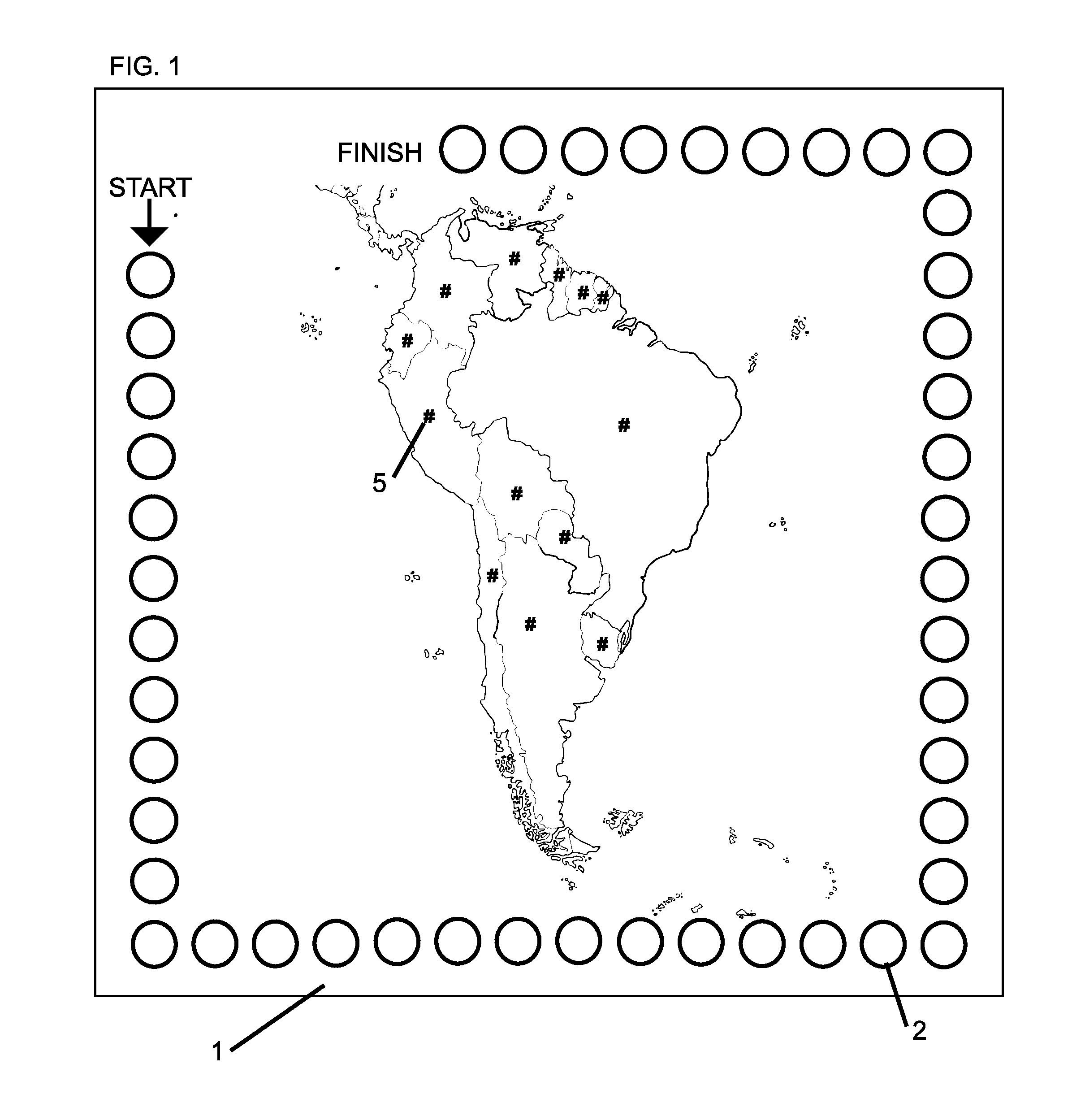
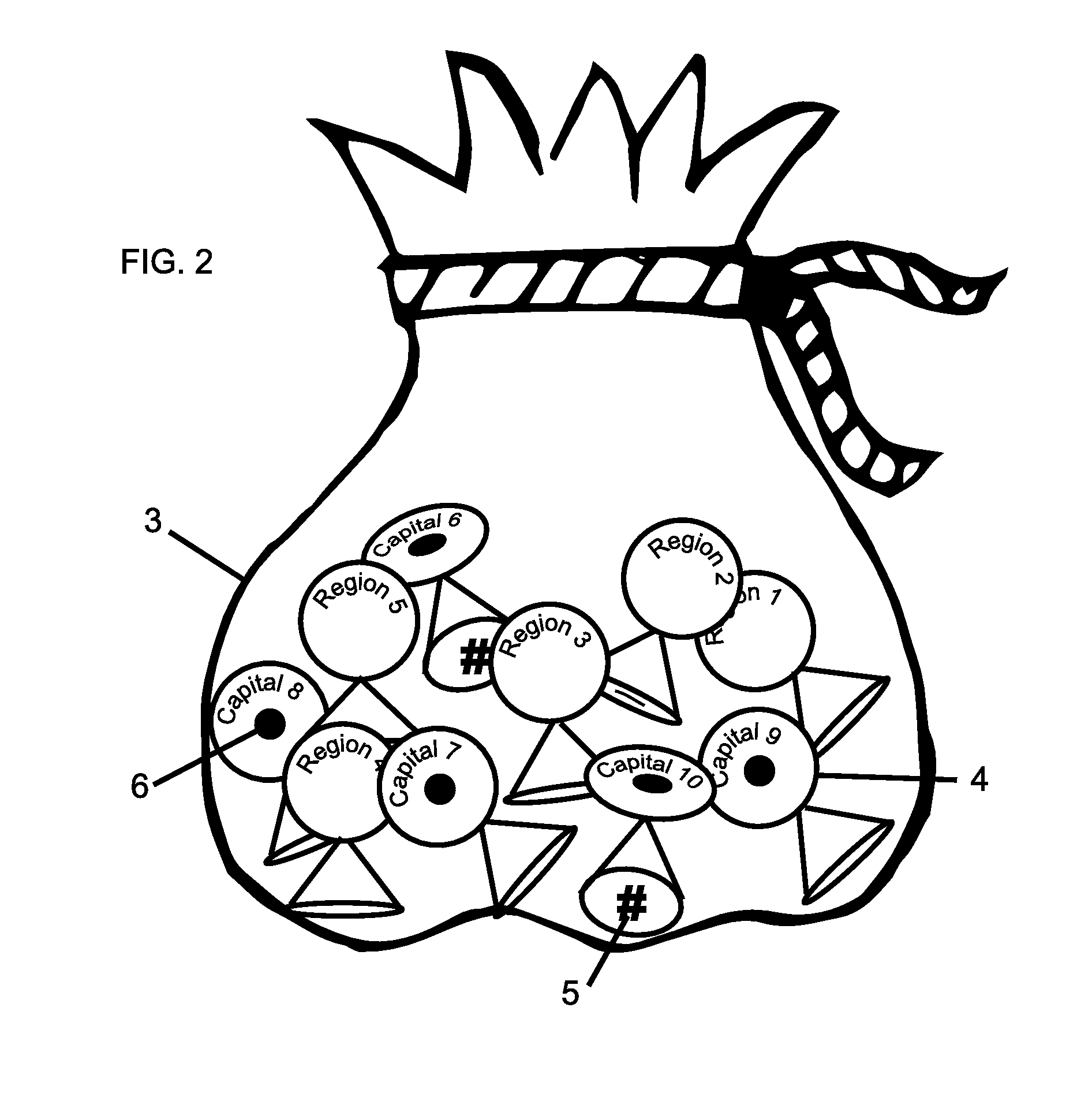
[0015]Components of the invention include: (1) map surface playing area, (2) tokens, (3) container, (4) booklet, (5) question and answer cards, (6) score tracker, (7) game piece markers, and (8) progression tracker.

[0016]The map surface playing area contains pictorial representations of geographical regions and / or geological features with each region or feature containing a map cross-reference number. A plurality of tokens, containing identifying region or geological feature information, corresponding map cross-reference numbers, and points, are individually drawn from the container during game play or for self-study. The supplemental booklet is used to enhance play level difficulty and for self-study. The question and answer cards provide supplemental historical and current event information related to regions and / or features represented on the map and are utilized during game play or for self-study. The game piece markers and score tracker, located on the map surface playing, are ...


PUM


Abstract

A comprehensive geography curriculum, game, and study aid geared toward home-school environments. The invention includes (a) an oversized map surface playing area containing unlabeled, pictorial representations of geographical regions or geological features including, without limitation, Africa, Antarctica, Asia, Australia-Oceania, Canada, Europe, North America, South America, the United States, and / or significant geological world features; (b) a plurality of labeled tokens which cross-reference with aforementioned regions or features represented on the map surface playing area; (b) a plurality of question and answer cards pertaining to historical data and current events of aforementioned regions or features represented on the map surface playing area; and (c) a booklet containing advanced information pertaining to regions or features represented on the map surface playing area. The method of play is designed as a multi-level, multi-sensory process which enhances retention and engages students in active learning through an entertaining medium. It also fosters self-study and instructor independence.

Description

CROSS REFERENCE TO RELATED APPLICATIONS[0001]Benefit claims to prior applications under 35 USC §119(e), this application claims the benefit of U.S. Provisional Application No. 61 / 647,810, filed on May 16, 2012.STATEMENT REGARDING FEDERALLY SPONSORED RESEARCH OR DEVELOPMENT[0002]Not ApplicableREFERENCE TO SEQUENCE LISTING, A TABLE, OR A COMPUTER PROGRAM LISTING COMPACT DISC APPENDIX[0003]Not ApplicableBACKGROUND OF THE INVENTION[0004]Geography students are presented with an enormous amount of information which must be memorized. Most prior and existing geography products rely heavily on labeled maps or globes thus requiring passive rather than active learning. Particularly, home-school students require an active method for effectively learning such material while simultaneously fostering independence in a multi-level environment. Existing or prior art does not provide a comprehensive, multi-level curriculum that engages students in hands-on, interactive play to enhance and expedite r...

Claims


Application Information

Patent Timeline
Patent Type & Authority Applications(United States)
IPC IPC(8): G09B29/00
CPCG09B29/003
Inventor SELF, TABBY LUQUETTE
Owner SELF TABBY LUQUETTE
Why Eureka
Try Eureka