
Automatic Blade Control System during a Period of a Global Navigation Satellite System ...

a global navigation satellite and automatic control technology, applied in the field of earthgrading machines, can solve the problem of affecting the accuracy of the control of the blade of the dozer, and achieve the effect of accurate blade control and accurate control of the blad

Inactive Publication Date: 2012-03-08
TOPCON POSITIONING SYST INC
View PDF10 Cites 48 Cited by
  • Summary
  • Abstract
  • Description
  • Claims
  • Application Information

AI Technical Summary

Benefits of technology

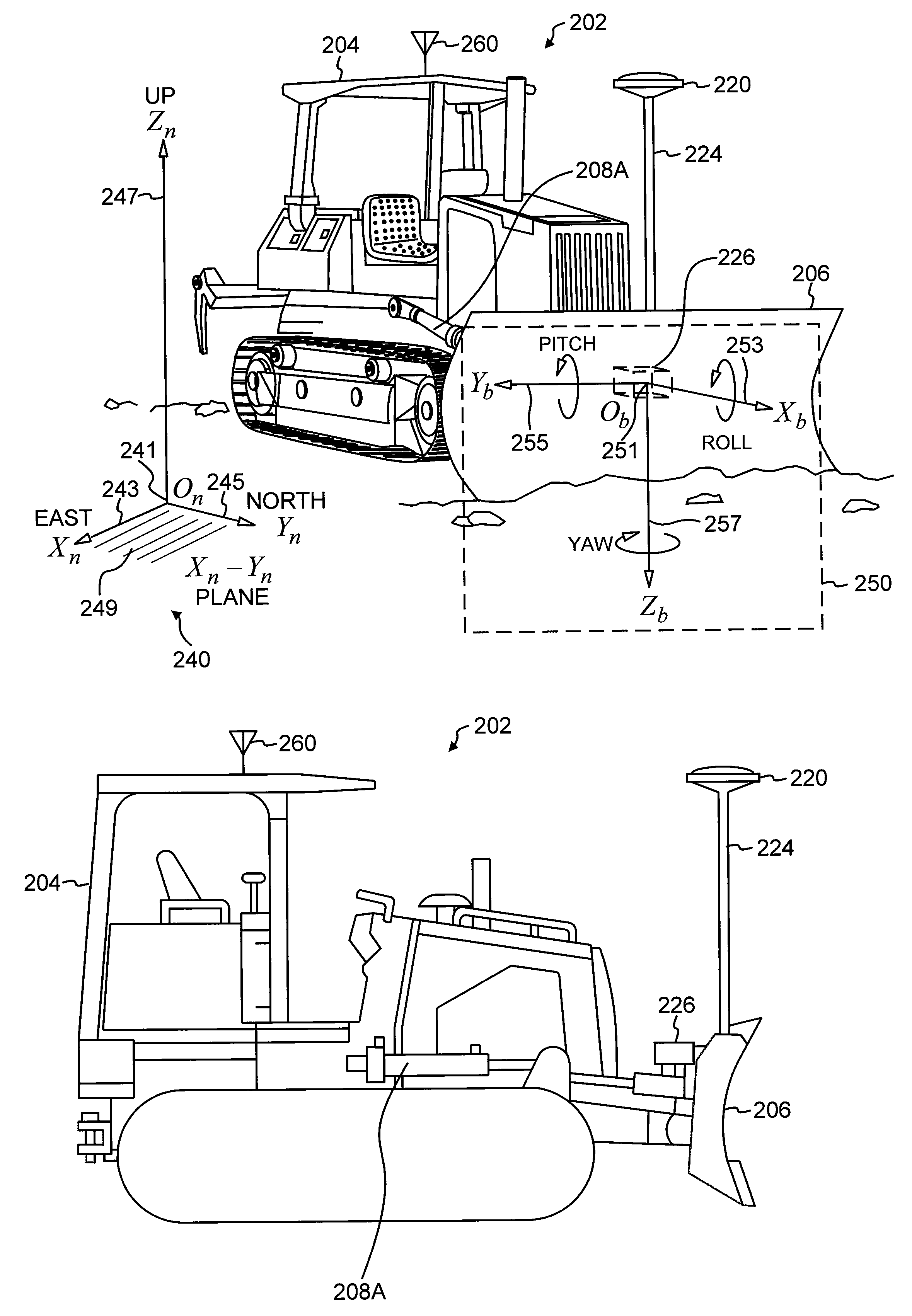
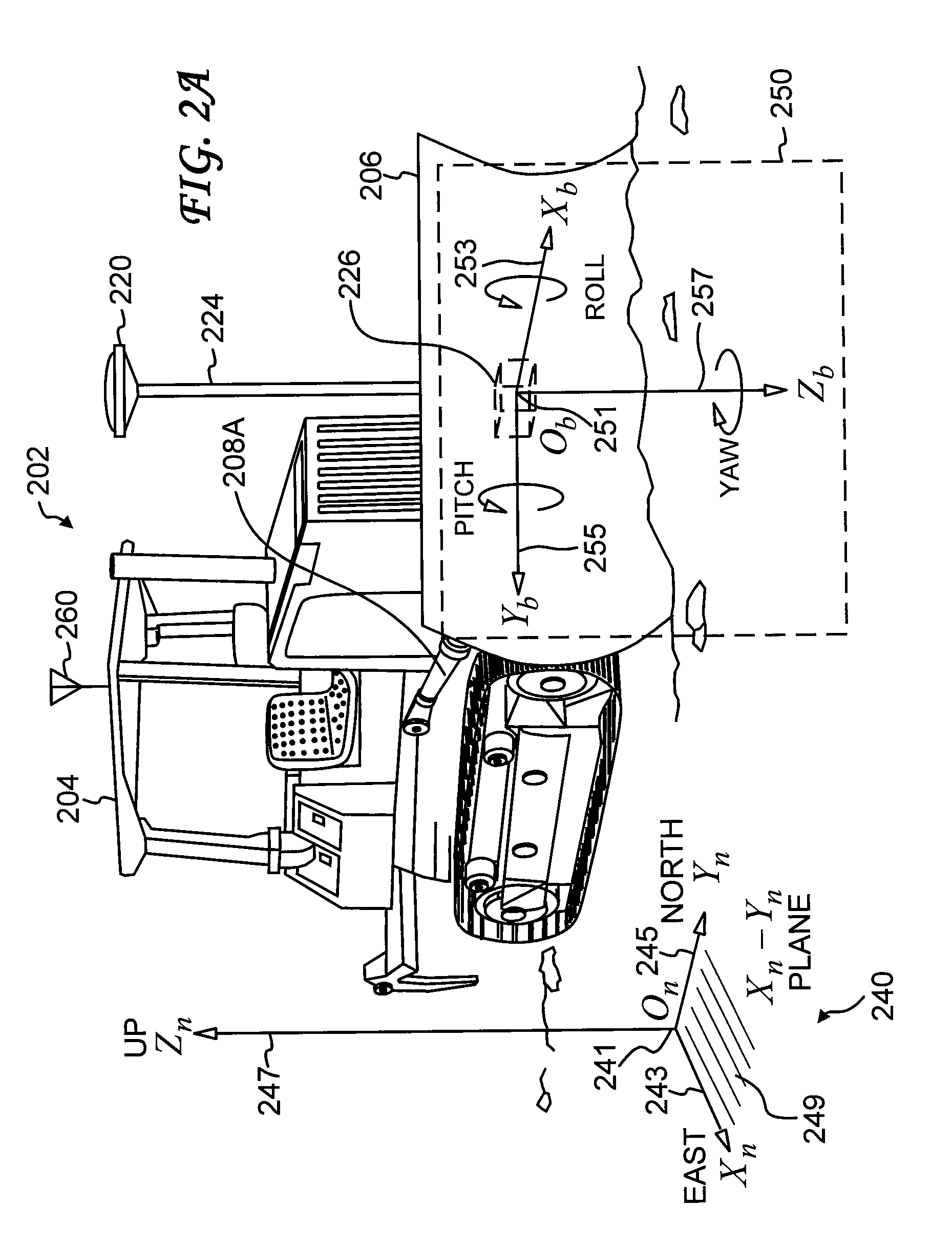
[0008]For precision grading of terrain by a dozer, the dozer blade is automatically controlled based on measurements from a combination of a global navigation satellite system real-time kinematic mode (GNSS RTK) system and inertial sensors. At least one GNSS sensor and at least one inertial sensor are mounted on the dozer. The dozer blade elevation and the dozer blade slope angle are controlled during periods of normal GNSS RTK system operation. Accurate control of the dozer blade is typically lost during a GNSS RTK system outage. In an embodiment of the invention, accurate blade control is maintained during a period of GNSS RTK system outage by controlling the dozer blade slope angle and the dozer blade pitch angle. The dozer blade slope angle and the dozer blade pitch angle are controlled based on an extrapolated target value of the dozer blade slope angle and an extrapolated target value of the dozer blade pitch angle. The extrapolated target values of the angles are extrapolated from target values of the angles prior to the GNSS RTK system outage with the use of a distance travelled by the dozer. The dozer blade slope angle and the dozer blade pitch angle are measured by various combinations of inertial sensors and hydraulic cylinder stroke sensors.

Problems solved by technology

Accurate control of the dozer blade is typically lost during a GNSS RTK system outage.

Method used


Image

  • Automatic Blade Control System during a Period of a Global Navigation Satellite System ...
  • Automatic Blade Control System during a Period of a Global Navigation Satellite System ...
  • Automatic Blade Control System during a Period of a Global Navigation Satellite System ...

Examples


Embodiment Construction

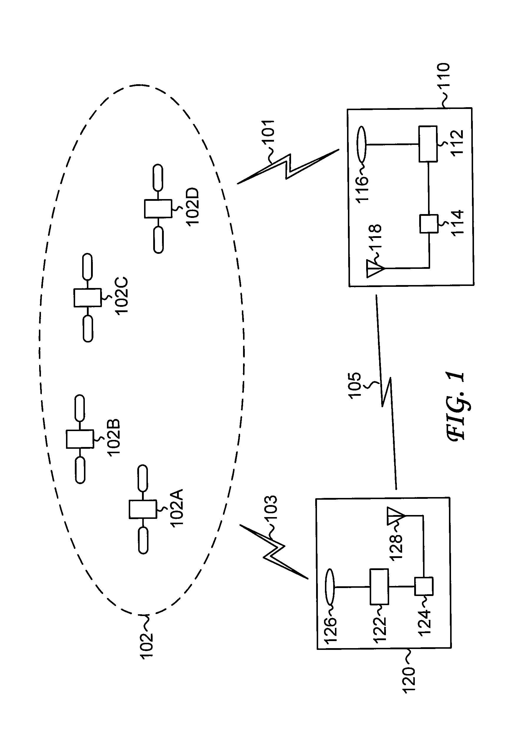
[0021]FIG. 1 shows a schematic of a global navigation satellite system (GNSS) real-time kinematic (RTK) mode system; to simplify the terminology, this system is referred to as a GNSS RTK system. The GNSS RTK system includes a base station (also referred to simply as a base) 110, a rover 120, and a constellation 102 of navigation satellites. In general, the base 110 is fixed or stationary, and its coordinates are precisely known. In general, the rover 120 is mobile.

[0022]The base 110 includes a navigation receiver 112 and an antenna 116 that receives satellite signals 101 from the constellation 102 of navigation satellites (shown are four representative navigation satellites, denoted navigation satellite 102A—navigation satellite 102D). Similarly, the rover 120 includes a navigation receiver 122 and an antenna 126 that receives satellite signals 103 from the constellation 102. The base 110 further includes a communications transceiver 114 and an antenna 118, and the rover further inc...


PUM


Abstract

For precision grading of terrain by a dozer, the dozer blade can be automatically controlled based on measurements from a combination of a global navigation satellite system real-time kinematic mode (GNSS RTK) system and inertial sensors. At least one GNSS sensor and at least one inertial sensor are mounted on the dozer. Control algorithms are based on blade elevation and blade slope angle. During a period of GNSS RTK system outage, control of blade elevation is not available. Blade control is maintained by switching to control algorithms based on blade slope angle and blade pitch angle. Blade slope angle and blade pitch angle are controlled based on extrapolated target values of blade slope angle and blade pitch angle. The extrapolated target values of the angles are extrapolated from target values of the angles prior to the GNSS RTK system outage with the use of a distance travelled by the dozer.

Description

[0001]This application claims the benefit of U.S. Provisional Application No. 61 / 379,465 filed Sep. 2, 2010, which is incorporated herein by reference.BACKGROUND OF THE INVENTION[0002]The present invention relates generally to earth-grading machines, and more particularly to an automatic blade control system for dozers.[0003]Global navigation satellite system (GNSS) sensors can determine locations with high accuracy. Currently deployed global navigation satellite systems include the United States Global Positioning System (GPS) and the Russian GLONASS. Other global navigation satellite systems, such as the European GALILEO system, are under development. In a GNSS, a navigation receiver receives and processes radio signals transmitted by satellites located within a line-of-sight distance of the navigation receiver. The satellite signals include carrier signals modulated by pseudo-random binary codes. The navigation receiver measures the time delays of the received signals relative to...

Claims


Application Information

Patent Timeline
Patent Type & Authority Applications(United States)
IPC IPC(8): E02F1/00E02F3/84G06F19/00
CPCE02F3/845E02F3/847G01C21/165G01S19/14G05D2201/0202G05D1/027G05D1/0274G05D1/0278G01S19/55G01C21/1654
Inventor OMELCHENKO, ALEXANDER N.ZHDANOV, ALEXEY V.
Owner TOPCON POSITIONING SYST INC
Learn More