
GNSS navigagtion aided by static data

Active Publication Date: 2011-09-29
GOOGLE LLC +1
View PDF10 Cites 8 Cited by
  • Summary
  • Abstract
  • Description
  • Claims
  • Application Information

AI Technical Summary

Benefits of technology

[0007]The present invention uses static data stored in a repository to assist a satellite navigation receiver. The navigation receiver may use data from this repository to improve its performance in terms of accuracy, sensitivity and TTFF. Aiding data in the repository may include, for example, a Digital Elevation Map (DEM), coordinates of tunnel entrances, and three-dimensional models of buildings in urban areas.
[0009]Additionally, the static repositories used may be updated in a timely fashion. Updates may be performed on a scheduled basis, by a request from the device containing the repository or by the authority that generates the data in the repository.

Problems solved by technology

Because clocks that could be synchronized that well with the atomic clocks used by the satellites are far too expensive for routine use, signals from four or more satellites are used to determine x, y, z and the time offset dt of the receiver's clock from the GPS clocks.

Method used


Image

  • GNSS navigagtion aided by static data
  • GNSS navigagtion aided by static data

Examples


Embodiment Construction

[0023]The principles and operation of GNSS navigation according to the present invention may be better understood with reference to the drawings and the accompanying description.

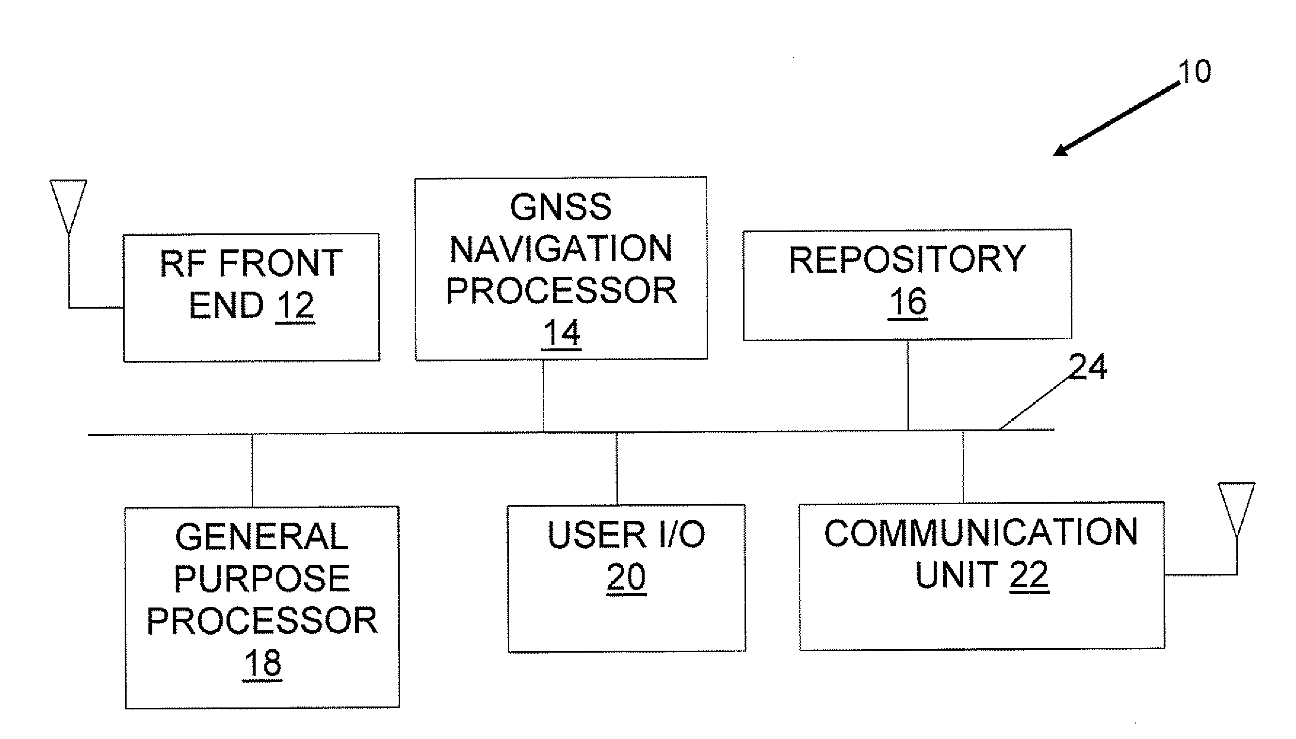
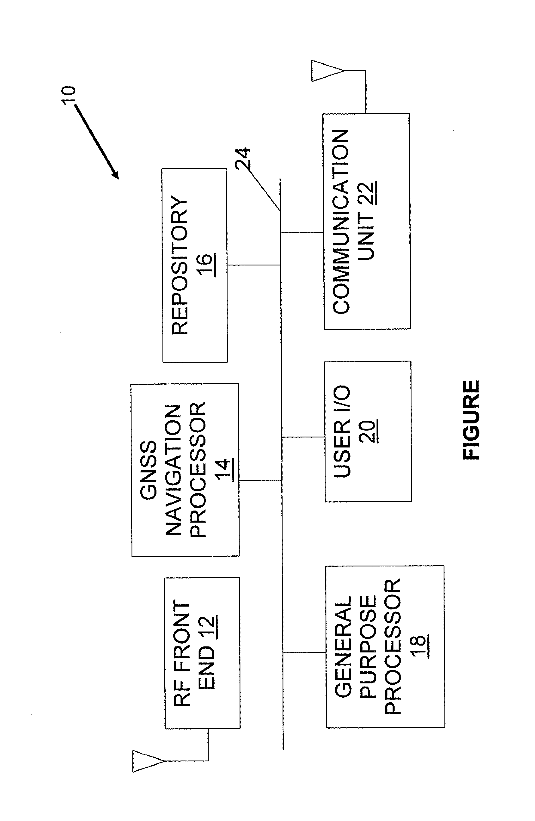
[0024]Referring now to the drawings, the FIGURE is a high-level block diagram of an exemplary GNSS receiver 10 of the present invention. GNSS receiver 10 includes a RF (Radio Frequency) front end 12, a GNSS navigation processor 14, a repository 16, a general purpose processor 18, conventional user input and output devices represented collectively by reference numeral 20 and a communication unit 22. Components 14, 16, 18, 20 and 22 communicate with each other via a common bus 24.

[0025]RF front end 12 receives ranging signals from a GNSS constellation such as the GPS constellation. GNSS navigation processor 14 uses the ranging signals received by RF front end 12, in conjunction with static data stored in repository 16, to compute the location of GNSS receiver 10. Apart from the assistance provided by the data ...


PUM


Abstract

A GNSS receiver includes a RF front end for receiving GNSS ranging signals, a navigation processor for calculating location from the ranging signals, and a repository of static data. The navigation processor includes the static data in the location calculation. Examples of static data include a digital elevation map, coordinates of tunnel entrances for use when the receiver resumes reception of the signals upon exiting a tunnel, and descriptions of structures in sufficient detail to enable multipath mitigation.

Description

[0001]This is a continuation-in-part of U.S. Provisional Patent Application No. 61 / 317,308, filed Mar. 25, 2010FIELD AND BACKGROUND OF THE INVENTION[0002]The present invention relates to GNSS (Global Navigation Satellite System) navigation and, more particularly, to GNSS navigation assisted by static data.[0003]A GNSS system is a space-based global navigation system in which the satellites of a constellation of satellites in orbit around the Earth transmit signals that are used by terrestrial receivers for purposes such as navigation. Such signals are called “ranging signals” herein. The existing GNSS systems include the GPS system operated by the United States of America and the GLONASS system operated by Russia. Forthcoming GNSS systems include the European Galileo system and the Chinese Compass navigation system.[0004]The operation of the GPS system now will be described as exemplary of how GNSS systems in general operate. The GPS system includes between 24 and 32 satellites in m...

Claims


Application Information

Patent Timeline
IPC IPC(8): G01S19/48
CPCG01S19/42G01S19/25G01S19/28G01S19/428
Inventor ROSENFELD, DVIREFRONI ROTMAN, BOAZ
Owner GOOGLE LLC
Learn More