Device, Program Product and Computer Implemented Method for Touchless Metrology Using an Inertial Navigation System and Laser

a technology of inertial navigation system and laser, applied in the field of devices, can solve problems such as drift and inability to accurately measure the distance between the inertial navigation system and the laser, and achieve the effect of precise and accurate navigation measuremen

Inactive Publication Date: 2011-02-17
IPOZ SYST
View PDF6 Cites 14 Cited by
  • Summary
  • Abstract
  • Description
  • Claims
  • Application Information

AI Technical Summary

Benefits of technology

[0009]A metrology device for use with an underwater vehicle or diving personnel is described herein, wherein the metrology device may comprise an inertial navigation system having gyroscopes to detect angular velocity and accelerometers for the detection of linear velocity and transported by an underwater robotic apparatus or diver, the inertial navigation system outputting position and orientation data for storage; an aiding device comprising a laser—or similar source—positioned in a relationship with an optical scanner so that when a light is emitted from the laser, the scanner is in a position to determine a characteristic of a reflective light from the laser for the purpose of measuring distance and orientation to points of reflection, the aiding device being positioned so that the distance and orientation between the optical scanner and the inertial navigation system is known, and the aiding device outputting laser data or similar ranging and or orientation information for storage; a controller having a microprocessor a timing device and memory, said control...

Problems solved by technology

Even given this high sample rate, the INS is subject to error.
This drift is especially problematic when the INS is used in underwater metrology i.e., the science of measuring accurately the position and orientation of objects and physical structures underwater (often on the seabed).
The draw back of such a method is that it requires that the INS carried by a robot (such as a Remotely Operated Vehicle or “...

Method used


Image

  • Device, Program Product and Computer Implemented Method for Touchless Metrology Using an Inertial Navigation System and Laser
  • Device, Program Product and Computer Implemented Method for Touchless Metrology Using an Inertial Navigation System and Laser
  • Device, Program Product and Computer Implemented Method for Touchless Metrology Using an Inertial Navigation System and Laser

Examples


Embodiment Construction

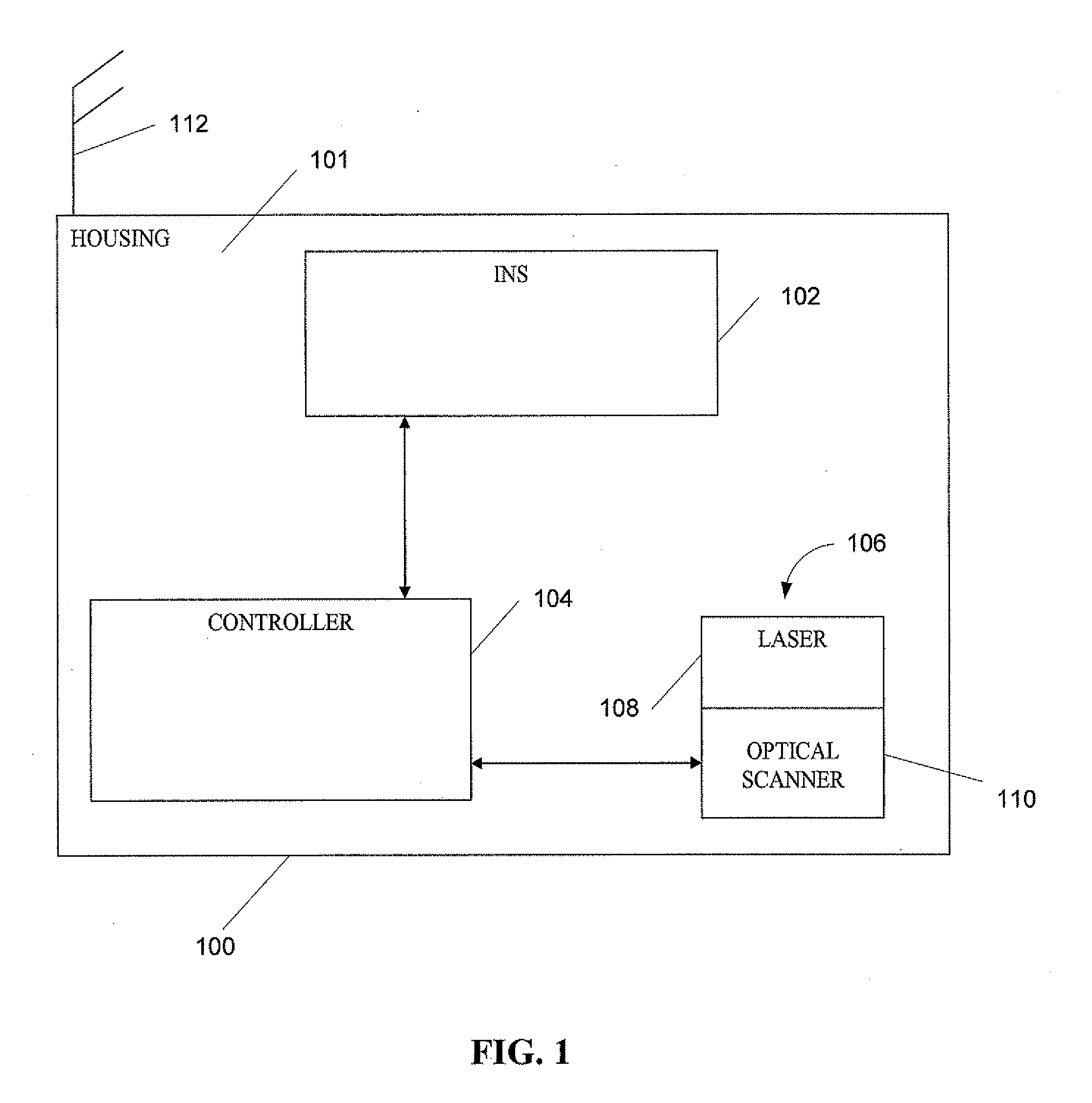
[0025]The present invention will now be described more fully hereinafter with reference to the accompanying drawings in which embodiments of the invention are shown. This invention may, however, be embodied in many different forms and should not be construed as limited to the illustrated embodiments set forth herein; rather, these embodiments are provided so that this disclosure will be thorough and complete, and will fully convey the scope of the invention to those skilled in the art. Like numbers refer to like elements throughout.

[0026]An INS is used in underwater metrology to measure the distance between two underwater features, such as jumper receptacles. An INS uses gyroscopes and accelerometers to measure micro-linear and micro-rotational movements to orient the body of a device and track device location. These readings can then be used to measure the distance between the two receptacles. Because this reading is disposed to error in the form of drift, embodiments of the presen...


PUM


Abstract

A metrology device, computer program product and computer-implemented method generating survey data without having the device touch subsea objects being surveyed. The metrology device may be used with an underwater vehicle or diving personnel, and may comprise an inertial navigation system having gyroscopes to detect angular velocity and accelerometers for the detection of linear velocity and transported by an underwater robotic apparatus or diver, the inertial navigation system outputting position and orientation data of the device for storage; an aiding device for collecting image data of the subsea objects, the aiding device being positioned so that the distance and orientation between the optical scanner and the inertial navigation system is known; and a computer for using the position information and image data between a successively visited known point to determine the drift of the metrology device and to use the drift of the metrology device to correct measurements of same.

Description

RELATED APPLICATION[0001]This applications claims the benefit of and priority from U.S. Provisional Patent Application Ser. No. 61 / 234,062, filed on Aug. 14, 2009, titled “A Device and Method for Touchless Inertial Metrology Using an Inertial Navigation System and Laser,” incorporated herein by reference in its entirety.BACKGROUND OF THE INVENTION[0002]1. Field of the Invention[0003]The invention relates to a method of making measurements on and between existing objects located underwater. More particularly, the invention relates to controlling the drift of an inertial navigation system using a range and bearing image capture system such as a laser camera or similar sensors, to make measurements without the system being in contact with an underwater object or the seabed. The spatial relationship between the inertial navigation system and the underwater object is achieved by range and bearing measurements.[0004]2. Description of the Prior Art[0005]Any motion of an object in space is ...

Claims


Application Information

Patent Timeline
IPC IPC(8): G06F19/00G01V9/00
CPCG01C21/165G01C21/06G01C21/1652G01C21/1656
Inventor TINK, CHARLES WILLIAM
Owner IPOZ SYST
Why Eureka
Try Eureka