Method for single satellite geolocation of emitters using an ambiguous interferometer array

an interferometer array and single satellite technology, applied in direction finders, instruments, measurement devices, etc., can solve the problems of critical aoa uncertainty, source generation of phase measurement ambiguities, and gross errors

Active Publication Date: 2009-03-26
NORTHROP GRUMMAN SYST CORP
View PDF12 Cites 28 Cited by
  • Summary
  • Abstract
  • Description
  • Claims
  • Application Information

AI Technical Summary

Problems solved by technology

Non cooperative transmitters are not necessarily attempting to avoid geolocation.
That is just not their reason for operating.
However, rapid, accurate location of these non cooperative emitters becomes important when they interfere with satellite communication.
By contrast, X band activity is generally military, and interference is typically hostile.
But it is also a problem since the emitter must lie simultaneously within the field of view of all the satellites, and be simultaneously detected by them.
So in this case the AOA uncertainty is critical.
However, increasing the baseline length beyond a half wavelength (λ / 2) of the signal source generates phase measurement ambiguities 105.
Hence it is called a gross error.
Aubain's multi-satellite technique does not adapt well to locating LEO jammers.
For example, reversing the roles of the low earth orbit and geosynchronous satellites will not work because of the GEO detection difficulty Nor does using two LEO satellites work since simultaneous emitter detection is a significant problem in low earth orbit.
It is a problem both because of weak signals, where one of the LEO satellites is far from the transmitter, and because the emitter may not be visible to all antennas in the detection satellite's array.
Coordination is a further major problem.
This is a difficulty for any multiple LEO satellite scheme, not just one based on Aubain's approach.
But with only LEO satellites, it is much too restrictive to assume a ground station with the required processing facilities will be visible to any of the satellites let alone all when the jammer transmits.
Jammers, however, are not so helpful.
Unfortunately the restriction to one special type of electromagnetic wave polarization greatly limits the method's usefulness.
Accordingly, there is currently no robust way to perform single satellite geolocation other than by measuring DOA by implementing a multielement antenna array equivalent to a planar interferometer.
However, the baselines for such an array are comparatively large and they typically are measured in meters rather than conventional centimeters.
Such arrays, however, do not support Az / El geolocation, but do support locating emitters using some form of triangulation or bearings-only geolocation over several dwells as the satellite moves in its orbit.
Hence even implementing an optimal interferometer with the minimal number of elements to solve the LEO location problem still generates what is derisively called by the satellite community an “antenna farm.” Accordingly, this solution is normally not practical or desirable to implement because of the space required on the satellite's surface.
This greatly limits what else can be installed.
This is generally unacceptable since locating interfering emitters would be an auxiliary task, not the primary mission of most LEO satellites.
This greatly extends and complicates the software processing required, but does not alter the basic method of using phase tracking to update the ambiguity integers (ni,mi), and then updating the candidate emitter locations.
A more significant drawback when trying to adapt the method to satellite applications is the extent of both the true and spurious error regions, e.g., regions 803 shown in FIG. 8B, especially for candidate emitter locations 804 relatively far from the suborbital point of range line 802.
But this somewhat erratic movement is difficult or even impossible to detect with Pentheroudakis' method because of the extent of the error region 816.
Now a comparatively large satellite orbital translation and hence significant time is required to create enough true DOA change to trigger integer updates and thus cause eventual large abrupt jumps in the spurious DOA to occur at other distant sites such as site 809.
When such jumps occur, because of the overlap of error regions these jumps may not eliminate wrong locations.
Another critical problem adapting Pentheroudakis' method to satellite based emitter location is the requirement for almost continuous sampling of the phase measurement.
But the most fundamental problem with continuous phase tracking is that the noncooperative emitter might not be transmitting or detected at each receiver dwell during the geolocation process.
For example, a simple way to defeat the Pentheroudakis scheme is to blink the emitter with a duty cycle that still interferes with satellite communication, but does not allow unwrapping of the candidate phases.
It can employ arrays designed using Malloy's optimal approach, but with the array not fully populated with antenna elements and hence producing ambiguous DOAs.

Method used


Image

  • Method for single satellite geolocation of emitters using an ambiguous interferometer array
  • Method for single satellite geolocation of emitters using an ambiguous interferometer array
  • Method for single satellite geolocation of emitters using an ambiguous interferometer array

Examples


Embodiment Construction

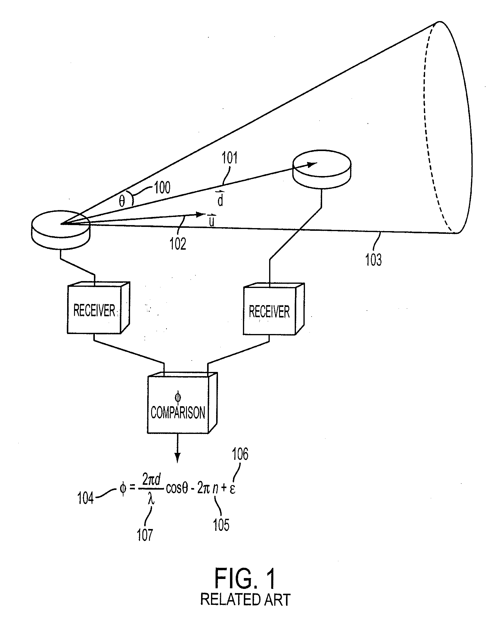
[0065]Referring now to the top level method block diagram in FIG. 9 and corresponding flow chart of FIG. 10, the following description is made first with reference to a three element array such as shown, for example, in FIG. 8A by reference numeral 800 which includes two interferometer baselines. A satellite at location 900 including a three element array 800 initially detects an emitter E whose true location is at location 901 shown in FIG. 9.

[0066]Upon initial detection, a set of steps in a Measure and Resolve Interferometer Phase processes 902 and a set of steps in a Generate Location Estimate and Location Statistics processes 903 are carried out. Special operations involving steps 902 and 903 of FIG. 9 unique to a first dwell step occur as shown in FIG. 10 by reference numeral 1000. All possible direction of arrival (DOA) vector ambiguity integer pairs (m, n) are found in step 1001 and each pair is associated with a unique Measure and Resolve Interferometer Phase process 902. Th...


PUM


Abstract

A method of locating a terrestrial emitter of electromagnetic radiation in the midst of a plurality of emitters in a satellite in orbit about the earth which utilizes a location estimation and location probability determination process with respect to each possible emitter site and its corresponding error region and then using both feedback and feed forward interaction between location and phase ambiguity resolution processes to generate resolved phase from emitter location, update emitter location or some or all of the emitters, and subsequently utilizing the probabilities thus determined to produce a single estimate of the desired emitter's location.

Description

CROSS-REFERENCE TO RELATED APPLICATIONS[0001]This is a continuation of application Ser. No. 11 / 806,179 filed May 30, 2007 for Method for Single Satellite Geolocation of Emitters Using an Ambiguous Interferometer array.BACKGROUND OF THE INVENTION[0002]1. Field of the Invention[0003]This invention relates generally to the location of objects from space via a satellite and, more particularly, to the accurate geolocation of possibly non-cooperative emitters from a single low earth orbit (LEO) satellite utilizing the minimum number of antennas required to derive ambiguous emitter direction of arrival.[0004]2. Description of Related Art[0005]Geolocation as used here refers to the determination of the emitter in both earth-center inertial (ECI) coordinates, and geodetic latitude and longitude. Using satellites to locate ground emitters is an important civilian and military task. Examples are emergency rescue of downed aircraft, determination of inadvertent sources of communications interfe...

Claims


Application Information

Patent Timeline
Patent Type & Authority Applications(United States)
IPC IPC(8): G01S5/04
CPCG01S3/48G01S5/12G01S5/04
Inventor ROSE, CONRAD M.
Owner NORTHROP GRUMMAN SYST CORP
Why Eureka
Try Eureka