Pobabilistic methods for mapping and localization in arbitrary outdoor environments

a technology of outdoor environment and probability, applied in the direction of navigation instruments, maps/plans/charts, instruments, etc., can solve the problems of not meeting the needs of many other applications, insufficient on its own for an array of navigation-related problems, and the best gps system available often yields worse accuracy than half a meter, etc., to achieve the effect of maximizing the likelihood of observed data

Inactive Publication Date: 2008-02-07
THE BOARD OF TRUSTEES OF THE LELAND STANFORD JUNIOR UNIV
View PDF13 Cites 326 Cited by
  • Summary
  • Abstract
  • Description
  • Claims
  • Application Information

AI Technical Summary

Benefits of technology

[0015]In another embodiment, the vehicle localizes itself relative to this map in a subsequent drive over the same section of terrain, using a computer algorithm that incorporates incoming sensor data from the vehicle by attempting to maximize the likelihood of the observed data given the map.

Problems solved by technology

Although GPS has been successful for many types of navigation, it does not meet the needs of many other applications.
Whereas GPS accuracy and coverage is sufficient for most air and sea navigation, it possesses several limitations that make it insufficient on its own for an array of navigation-related problems on the ground.
Even the best GPS systems available frequently yield worse accuracy than half a meter, an error that may be intolerably large for unmanned vehicle guidance, or for certain driver assistance systems.
A second problem is reliability.
Loss of data for even brief periods can lead to unreliable systems.
While such systems are successful, they exist only in a small fraction of locations.
Furthermore, their installation is prohibitively expensive and time consuming for the vast majority of environments, and is simple infeasible in many.
Because such systems require a high initial monetary and time cost, they are not generally applicable to outdoor navigation in arbitrary environments.
While such techniques are sometimes effective, they rely generally on easily-identifiable landmarks and are prone to error and inaccuracy, especially under unpredictable lighting.
These systems are thus ill-suited for reliable, high-accuracy localization.
While such techniques are often effective in providing a vehicle's location relative to such a map, the maps themselves are of insufficient accuracy to provide for fully autonomous driving or for driver assistance systems that require high precision.
For example, while they may allow a vehicle to determine what road it is on and approximately where along the road it is, they are unable to determine which lane the vehicle is in, let alone an accurate location within the lane.
Thus the limited accuracy and fundamental reliance only on GPS and odometry data prohibit such systems from achieving sufficient accuracy for many problems related to ground navigation.
In some sense, indoor environments are more difficult to map than outdoor environments, since indoor robots do not have access to a source of global accurate position measurements such as GPS.
However, this is not the case.
Even in areas where GPS is available, the localization error often exceeds one meter.
Such errors are too large for precision vehicle navigation.
This problem is even more severe in urban environments where GPS reception is often blocked by buildings and vegetation, and signals are subject to multipath reflections.
As a result, GPS-based localization in cities is often inaccurate and too unreliable for autonomous robot driving.
This renders GPS alone unsuitable for vehicle guidance on the ground.

Method used


Image

  • Pobabilistic methods for mapping and localization in arbitrary outdoor environments
  • Pobabilistic methods for mapping and localization in arbitrary outdoor environments
  • Pobabilistic methods for mapping and localization in arbitrary outdoor environments

Examples


Embodiment Construction

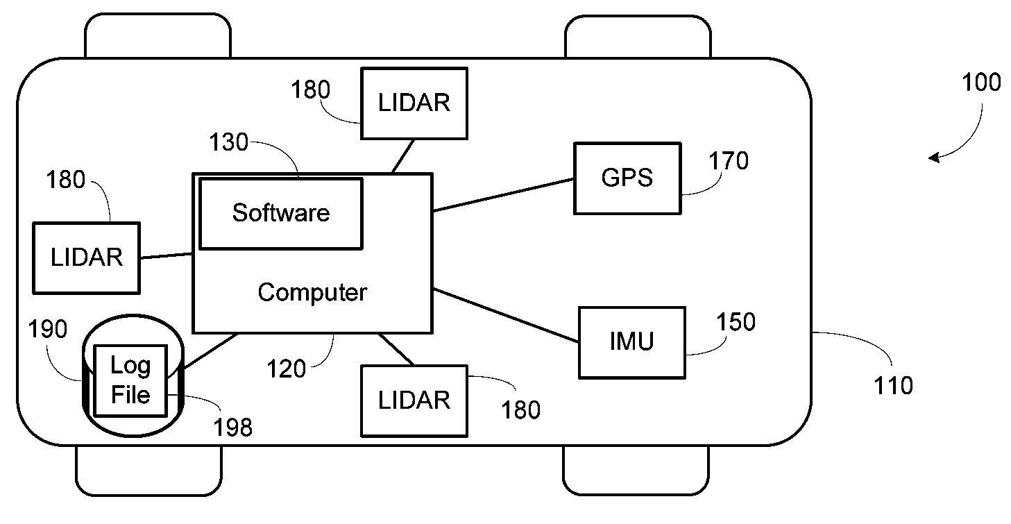
[0024]In an unmanned vehicle, driving autonomously on today's roads, it is necessary to obtain an accurate position estimate that provides a precise location within a lane, with a precision of a few centimeters, and in GPS-denied environments (e.g., in a tunnel). In the preferred embodiment a human first drives a vehicle on a network of roads, with the vehicle recording position data from a GPS receiver and scene data from laser scanners, which are processed into a high-resolution map file. Later, a vehicle, manned or unmanned, drives on this same network of roads, and using its sensors is able to determine its position on the road relative to the map file with significantly greater accuracy than GPS alone affords. It can also determine its position when GPS is temporarily unavailable, e.g., in narrow urban canyons. The resulting precision and reliability is a key prerequisite of autonomous unmanned ground vehicle operation.

[0025]In an in-car navigation system, the ability to track ...


PUM


Abstract

Systems and methods which provide mapping an arbitrary outdoor environment and positioning a ground-based vehicle relative to this map. In one embodiment, a land-based vehicle travels across a section of terrain, recording both location data from sensors such as GPS as well as scene data from sensors such as laser scanners or cameras. These data are then used to create a high-resolution map of the terrain, which may have well-defined structure (such as a road) or which may be unstructured (such as a section of desert), and which does not rely on the presence of any “landmark” features. In another embodiment, the vehicle localizes itself relative to this map in a subsequent drive over the same section of terrain, using a computer algorithm that incorporates incoming sensor data from the vehicle by attempting to maximize the likelihood of the observed data given the map.

Description

BACKGROUND OF THE INVENTION[0001]1. Field of the Invention[0002]The present invention relates to software algorithms that integrate various sensor data for the purpose of building high resolution maps for use by a land-based vehicle and to accurately and reliably determine the position of the land-based vehicle.[0003]2. Description of the Related Art[0004]Interest in precision localization of moving vehicles is increasing rapidly. Accurate and reliable localization is necessary for guidance of unmanned ground vehicles, with such vehicles affording significant military and consumer applications. Accurate and reliable localization is also necessary for an array of systems that assist human drivers in the form of navigational aids and safety-related assistance systems.[0005]Present techniques for localizing outdoor vehicles rely almost entirely on Global Position System (GPS) satellites, which allow a receiver to observe signals from multiple geosynchronous satellites and thereby trian...

Claims


Application Information

Patent Timeline
Patent Type & Authority Applications(United States)
IPC IPC(8): G01C21/00
CPCG01C15/00G09B29/00G01S19/49G01S5/0252G01C21/20
Inventor LEVINSON, JESSE SOLTHRUN, SEBASTIANMONTEMERLO, MICHAEL STEVEN
Owner THE BOARD OF TRUSTEES OF THE LELAND STANFORD JUNIOR UNIV
Why Eureka
Try Eureka