
Distributed orbit modeling and propagation method for a predicted and real-time assisted GPS system

a distributed orbit and gps technology, applied in the field of satellite orbit modeling, predicting, and utilizing satellite orbits, can solve the problems of inability to provide orbit predictions in advance to a gps receiver, and achieve the effect of simplifying the integration of the pgps clien

Active Publication Date: 2008-01-24
RX NETWORKS INC
View PDF1 Cites 66 Cited by
  • Summary
  • Abstract
  • Description
  • Claims
  • Application Information

AI Technical Summary

Benefits of technology

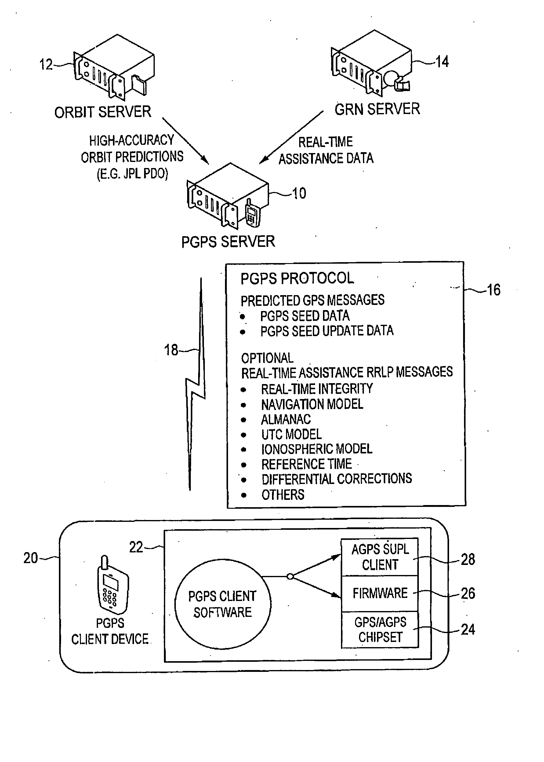
The invention provides a method for a predicted GPS or GNSS system that includes a predicted GPS server, a source of high accuracy orbit predictions, a global reference network, and a predicted GPS client. The PGPS client runs on a device equipped with a GPS or AGPS chipset and receives PGPS seed data from the PGPS server. The PGPS seed data is used to propagate satellite orbits and calculate associated synthetic ephemerides. The PGPS client can also act as a source of assistance data for other PGPS client devices. The PGPS system can process blended standard real-time assistance data and predictive assistance data, and can automatically update the seed data to ensure the PGPS client operates with the latest orbit prediction model. The technical effects of the invention include reducing network traffic savings and providing efficient assistance data to GPS receivers.

Problems solved by technology

When the GPS satellites are moved in their orbits for routine maintenance procedures, orbit predictions provided in advance to a GPS receiver are in error.

Method used


Image

  • Distributed orbit modeling and propagation method for a predicted and real-time assisted GPS system
  • Distributed orbit modeling and propagation method for a predicted and real-time assisted GPS system
  • Distributed orbit modeling and propagation method for a predicted and real-time assisted GPS system

Examples


Embodiment Construction

[0037] In the following description, the acronyms used together with their meaning are set forth below:

AGPSAssisted GPSASNAbstract Syntax Notation OneDGPSDifferential GPSGPSGlobal Positioning SystemGRNGlobal Reference NetworkH-SLPHome SUPL Location PlatformHTTPHypertext TransferIMSIInternational Mobile Subscriber IdentityIODEIssue of Data EphemerisIPInternet ProtocolLCSLocation ServicesJPLJet Propulsion LaboratoryMIDPMobile information Device ProfileMSMobile StationOMAOpen Mobile AllianceP-CodePrecision CodePERPacked Encoding RulesPGPSPredicted GPSPRNPseudo Range NumberRTIReal Time IntegrityRRCRadio Resource ControlRRLPRadio Resource LCS ProtocolSETSUPL Enabled TerminalSLPSUPL Location PlatformSMSShort message ServiceSUPLSecure User Plan LocationTCPTransmission Control ProtocolTTFFTime to First FixTIATelecommunications Industry AssociationLIRAUser Range AccuracyUTCUniversal Coordinated TimeV-SLPVisitor SUPL Location PlatformWAPWireless Application ProtocolXMLExtensible Markup Lang...


PUM


Abstract

A distributed orbit and propagation method for use in a predicted GPS or GNSS system, which includes a predicted GPS server (PGPS Server), a source of high accuracy orbit predictions (Orbit Server), a global reference network (GRN Server) providing real-time GPS or GNSS assistance data to the PGPS Server, a predicted GPS client (PGPS Client) running on a device equipped with a GPS or AGPS chipset. In response to requests from the PGPS Client, the PGPS Server produces and disseminates an initial seed dataset consisting of current satellite orbit state vectors and orbit propagation model coefficients. This seed dataset enables the PGPS Client to locally predict and propagate satellite orbits to a desired future time. This predictive assistance in turn helps accelerate Time To First Fix (TTFF), optimize position solution calculations and improve the sensitivity of the GPS chip present on, or coupled with, the device. In contrast with other conventional predicted GPS systems that forward large volumes of predicted orbits, synthetic ephemeris or synthetic almanac data, this method optimally reduces data transfer requirements to the client, and enables the client to locally synthesize its own predicted assistance data as needed. This method also supports seamless notification of real-time satellite integrity events and seamless integration of predicted assistance data with industry standard real-time assistance data.

Description

FIELD [0001] The present invention describes a method and apparatus for modeling, predicting, and utilizing satellite orbits with the data processing distributed between a centralized server and a client. In particular, the invention is applied to the Global Positioning System (GPS) satellites, but is equally applicable to other Global Navigation Satellite Systems (GNSS) as well as other future or planned satellite systems. The present invention relates to a predicted GPS system in a mobile communications network, whereby the predicted GPS client can propagate satellite orbits from an initial seed dataset provided by a predicted GPS server for several days into the future with minimal degradation in position accuracy, and utilize the predicted data to assist the GPS chip present on, or coupled with, the device. This predictive assistance in turn helps accelerate Time To First Fix (TTFF), optimize position solution calculations and improve the sensitivity of the GPS chip present on, ...

Claims


Application Information

Patent Timeline
Patent Type & Authority Applications(United States)
IPC IPC(8): H04B7/185G01S19/25
CPCG01S19/05H04W4/02G01S19/27G01S19/258G01C21/20
Inventor LAMANCE, JAMESWEAGEN, MARIAROY-MACHABEE, GUYLAIN
Owner RX NETWORKS INC
Learn More