Auxilliary Navigation System For Use In Urban Areas

a navigation system and urban area technology, applied in the field of image processing, can solve the problems of poor readings in dense urban surroundings, inability of the vehicle crew to locate itself accurately, and never easy to fight in urban environments. achieve the effect of increasing the dynamic range of gradient images

Inactive Publication Date: 2007-12-13
MISTRAL DETECTION LTD
View PDF6 Cites 22 Cited by
  • Summary
  • Abstract
  • Description
  • Claims
  • Application Information

AI Technical Summary

Problems solved by technology

Fighting in an urban environment was never an easy task for any regular army.
These vehicles usually have a navigation system based on GPS (Global Positioning System) that tends to give poor readings in dense urban surroundings.
This creates situations in which the crew of the vehicle fails to locate itself accurately.
In urban areas the skies are mostly obscure by surrounding buildings and the GPS system fails to deliver a reliable solution.
Proper operation of these solutions requires continuous and uninterrupted communication between the receptor and the external station.
Such communication is not always possible due to physical blockage caused by buildings, etc; electronic warfare; and numerous additional reasons.
As of yet, no real solution to the problems discussed above has been suggested.
It is important to mention that in cases as described above, the use of a map and compass is close to useless since most of the surroundings are obscured and it is very difficult to find one's location in the map.
Also, when dealing with autonomous vehicles, such a solution is not suitable.

Method used


Image

  • Auxilliary Navigation System For Use In Urban Areas
  • Auxilliary Navigation System For Use In Urban Areas
  • Auxilliary Navigation System For Use In Urban Areas

Examples


Embodiment Construction

[0039] Publications and other reference materials referred to herein, including reference cited therein, are incorporated herein by reference in their entirety and are numerically referenced in square brackets in the following text and respectively grouped in the appended Bibliography which immediately precedes the claims.

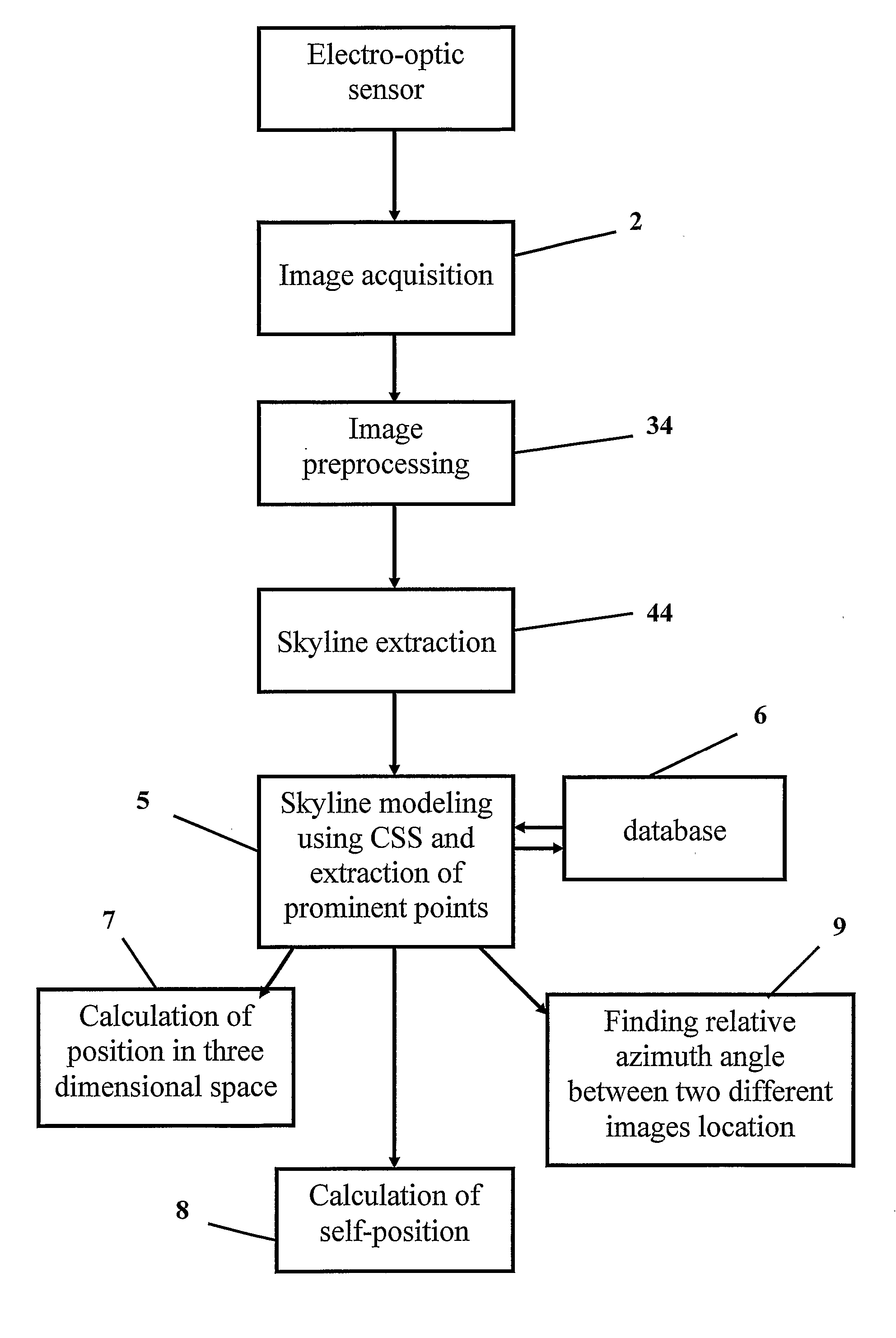
[0040] The method of the invention is carried out using a mobile electro-optic device that is designed to be mounted on any mobile platform, such that a clear view of the surroundings is available for the purpose of self-positioning and / or following a previously traversed track. The system is also suitable for allowing the estimation of the platform's orientation in three dimensional space relative to any arbitrary coordinates system. The system of the invention described herein comprises a circumferential imaging sensor assembly along with a processing unit, capable of extracting from the surroundings prominent, robust features that do not tend to vary over time,...


PUM


Abstract

The invention is a method for the extraction, identification and comparison of skylines from imagery data specifically, for the purpose of accurately locating the position of a mobile platform for navigation purposes. The invention is carried out by processing images obtained using a compact mobile electro-optic device that is designed to be mounted on any mobile platform, such that a clear circumferential view of the surroundings is available. The method allows the position of the mobile platform to be determined in three dimensional space, relative to any arbitrary coordinate system; the exact map coordinates of the platform to be determined; or allows the platform to follow a previously traversed track.

Description

FIELD OF THE INVENTION [0001] The present invention relates to the field of imaging. Specifically, the invention is related to the field of computer vision. More specifically, the invention relates to methods for accurately locating the position of vehicles for navigation purposes. BACKGROUND OF THE INVENTION [0002] Today's modern armies make wide use of computer based systems. These armies rely on sophisticated systems to deliver to the forces in the front the latest and most reliable information. One of the key types of information needed is the accurate location of ground forces, especially in intricate and complicated situations such as urban warfare. [0003] Urban warfare has become, in today's battlefields, more and more common. Many of the conflicts today involve war against local militia which operates from within local innocent population located in dense urban areas. [0004] Fighting in an urban environment was never an easy task for any regular army. Regular armies depend o...

Claims


Application Information

Patent Timeline
Patent Type & Authority Applications(United States)
IPC IPC(8): G06K9/78B61BG06K9/00
CPCG06K9/00664G06K9/00791G06V20/10G06V20/56
Inventor GAL, EHUDGREENHUT, YARON
Owner MISTRAL DETECTION LTD
Why Eureka
Try Eureka