Eureka AIR delivers breakthrough ideas for toughest innovation challenges, trusted by R&D personnel around the world.

Method and apparatus for validating a position in a satellite positioning system using range-rate measurements

a satellite positioning system and range-rate measurement technology, applied in the field of satellite positioning systems, can solve the problems of large position errors, large range errors of up to 0.8 m, and similar sized errors in the position of gps receivers

Inactive Publication Date: 2006-12-07
AVAGO TECH WIRELESS IP SINGAPORE PTE
View PDF9 Cites 14 Cited by
  • Summary
  • Abstract
  • Description
  • Claims
  • Application Information

AI Technical Summary

Problems solved by technology

Absolute timing errors result in range errors of up to 0.8 m for each millisecond of timing error.
These range errors produce a similarly sized error in the GPS receiver position.
Hence, absolute time accuracy of 10 ms is sufficient for position accuracy of approximately 10 m. Absolute timing errors of much more than 10 ms will result in large position errors, and so typical GPS receivers have required absolute time to approximately 10 milliseconds accuracy or better.
As discussed above, an absolute time error of 1 millisecond leads to range errors of up to 0.8 meters while an absolute time error of 1 microsecond would cause an almost unobservable range error of less than 1 millimeter.
A common mode error of 1 microsecond, however, results in a pseudorange error of 1 microsecond multiplied by the speed of light (i.e., 300 meters).
Common mode errors have a large effect on pseudorange computations, and it is, in practice, very difficult to calibrate the common mode error.
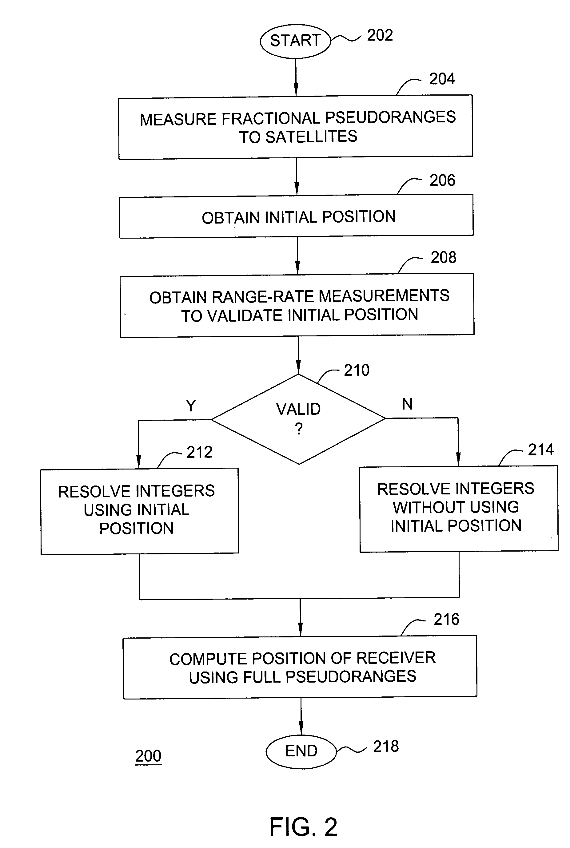
For example, the receiver may be unable to communicate with any external source capable of providing a position estimate (e.g., a cellular telephone network).
However, if the receiver has traveled more than 150 kilometers from the last computed position, than the pseudorange integers will not be reliably resolved.
If a position is computed using pseudoranges having incorrect integers, the position will be invalid.

Method used


Image

  • Method and apparatus for validating a position in a satellite positioning system using range-rate measurements
  • Method and apparatus for validating a position in a satellite positioning system using range-rate measurements
  • Method and apparatus for validating a position in a satellite positioning system using range-rate measurements

Examples


Embodiment Construction

[0021] A method and apparatus for validating a position in a satellite positioning system (SPS) using range-rate measurements is described. Those skilled in the art will appreciate that the invention may be used with various types of mobile or wireless devices that are “location-enabled,” such as cellular telephones, pagers, laptop computers, personal digital assistants (PDAs), and like type wireless devices known in the art. Generally, a location-enabled mobile device is facilitated by including in the device the capability of processing satellite positioning system (SPS) satellite signals.

[0022]FIG. 1 is a block diagram depicting an exemplary embodiment of a position location system 100. The system 100 comprises a remote receiver 102 and a server 108. The remote receiver 102 is configured to receive satellite signals from a plurality of satellites 112 in a constellation of satellites. The remote receiver 102 processes the received signals to produce satellite measurement data (e....


PUM


Abstract

Method and apparatus for validating an initial position in a satellite positioning system using range-rate measurements is described. In one example, range-rate measurements are obtained at the remote receiver with respect to a plurality of satellites. Expected range-rates are computed with respect to the plurality of satellites using the initial position. Single differences are computed using the range-rate measurements. Expected single differences are computed using the expected range-rates. Single difference residuals are computed between the single differences and the expected single differences. The single difference residuals are compared to a threshold. The initial position may be deemed valid if the absolute value of each of the single difference residuals is less than or equal to the threshold. A valid initial position may be used to fix the pseudorange integers.

Description

BACKGROUND OF THE INVENTION [0001] 1. Field of the Invention [0002] The present invention relates to satellite positioning systems and, more particularly, to a method and apparatus for validating a position in a satellite positioning system using range-rate measurements. [0003] 2. Description of the Background Art [0004] Satellite Positioning System (SPS) receivers use measurements from several satellites to compute position. SPS receivers normally determine their position by computing time delays between transmission and reception of signals transmitted from satellites and received by the receiver on or near the surface of the earth. The time delays multiplied by the speed of light provide the distance from the receiver to each of the satellites that are in view of the receiver. Exemplary satellite positioning systems include the Global Positioning System (GPS), the European GALILEO system, and the Russian GLONASS system. [0005] In GPS, each signal available for commercial use util...

Claims


Application Information

Patent Timeline
Patent Type & Authority Applications(United States)
IPC IPC(8): G01S5/14G01S19/42
CPCG01S19/42G01S19/13G01S19/06G01S19/254
Inventor DIGGELEN, FRANK VAN
Owner AVAGO TECH WIRELESS IP SINGAPORE PTE
Why Eureka
Eureka Blog
Learn More