
User-centric event reporting with follow-up information

a user-centric, event-based technology, applied in traffic control systems, wireless communication, instruments, etc., can solve the problems of system wasteful evasion by drivers not realistically at risk, and not providing the kind of information that would permit a vehicle operator to opera

Inactive Publication Date: 2005-10-27
USER CENTRIC IP LP
View PDF58 Cites 141 Cited by
  • Summary
  • Abstract
  • Description
  • Claims
  • Application Information

AI Technical Summary

Benefits of technology

"The invention is a system and method for receiving and using information about hazards or life-threatening events to alert users of mobile devices in advance. The system uses a database and display to show hazards across a large area, and also receives information about the user's location. The system can also display a rotating map with the user's current location and the predicted path of travel. The user can select the type of hazard and receive a warning based on the location. The system can also receive secondary information about the hazard, such as blood pressure or EKG information, and display it along with the warning. Overall, the invention helps users to better prepare for hazards and make informed decisions."

Problems solved by technology

Because they cover such large areas, however, generalized weather forecasts may cause wasteful evasive action by drivers not realistically at risk.
Such a system would be particularly useful for fleets of commercial trucks or buses, for example, particularly since such vehicles may be more susceptible to causing injury or property damage during severe weather events (e.g., snow, ice storms, and the like).
However, the system cannot provide the sort of information that would permit a vehicle operator to determine whether he or she was likely to encounter a weather hazard and for how long such a hazard might last.
The system, however, does not provide predicted weather information to the vehicle operator; it does not provide hazard duration information; and it does not provide weather information tailored to the particular vehicle.
Consequently, the system does not solve the aforementioned problems.
The system has no application for use with moving vehicles, as it cannot receive information concerning the mobile location of such vehicles.
In addition to the above, because we live in an increasingly mobile society, individuals are more likely to get lost or disoriented in unfamiliar territory and have their safety threatened by severe weather conditions.
While some of these accidents were due to operator error, others are due to the driver, pilot or operator of the vehicle traveling into an area of hazardous weather beyond his or her skill level or the capability of his or her vehicle to handle the inclement weather.
Current terrestrial navigation and weather systems suffer from several deficiencies: 1) receipt of a warning depends on a user being tuned to a radio station in the affected area that actually broadcasts storm warnings (in addition, many radio stations no longer broadcast warnings outside of the immediate area in which they are located); 2) warnings, e.g., NWR tone alerts, are only broadcast once—if the user misses the warning, the user will not be notified of the impending inclement conditions; and 3) if the user is not tuned to the correct radio station at the time of the warning, the user will miss the warning.
However, when traveling, few people know which county they are currently in or which county they are approaching, other than when in or around their own home county.
However, most people are not cognizant of this information.
This approach has a number of shortcomings, including ease with which a user can still get lost, and inability to adapt to non-fixed range conditions.
That is, users who cannot easily read and interpret maps may still get lost.
Fixed ranges may be appropriate when a map display is used for navigation only, but fixed ranges are not appropriate when a device is used to anticipate hazardous conditions.
There would be no way for the user to avoid or escape on this limited-access rural highway.
No forecast information is available on AnywhereWx, nor does it have the capability of changing ranges or otherwise notifying a pilot or user of hazardous conditions in the travel path.
There is no technology to predict when the path of hazardous weather and a moving user will intersect.
However, there is no weather information on the Neverlost system.
In addition, because the Neverlost system is designed to assist automobile renters who are generally unfamiliar with the locale in which they have rented the car, the close-up fixed map range is inappropriate for meteorological display and warning purposes.
In addition to the above limitations, known systems typically provide, at most, only location information regarding the mobile device.
That is, the mobile device cannot be used to report information, other than location information, from the mobile device to a second party, e.g., another user or a central server.

Method used


Image

  • User-centric event reporting with follow-up information
  • User-centric event reporting with follow-up information
  • User-centric event reporting with follow-up information

Examples


Embodiment Construction

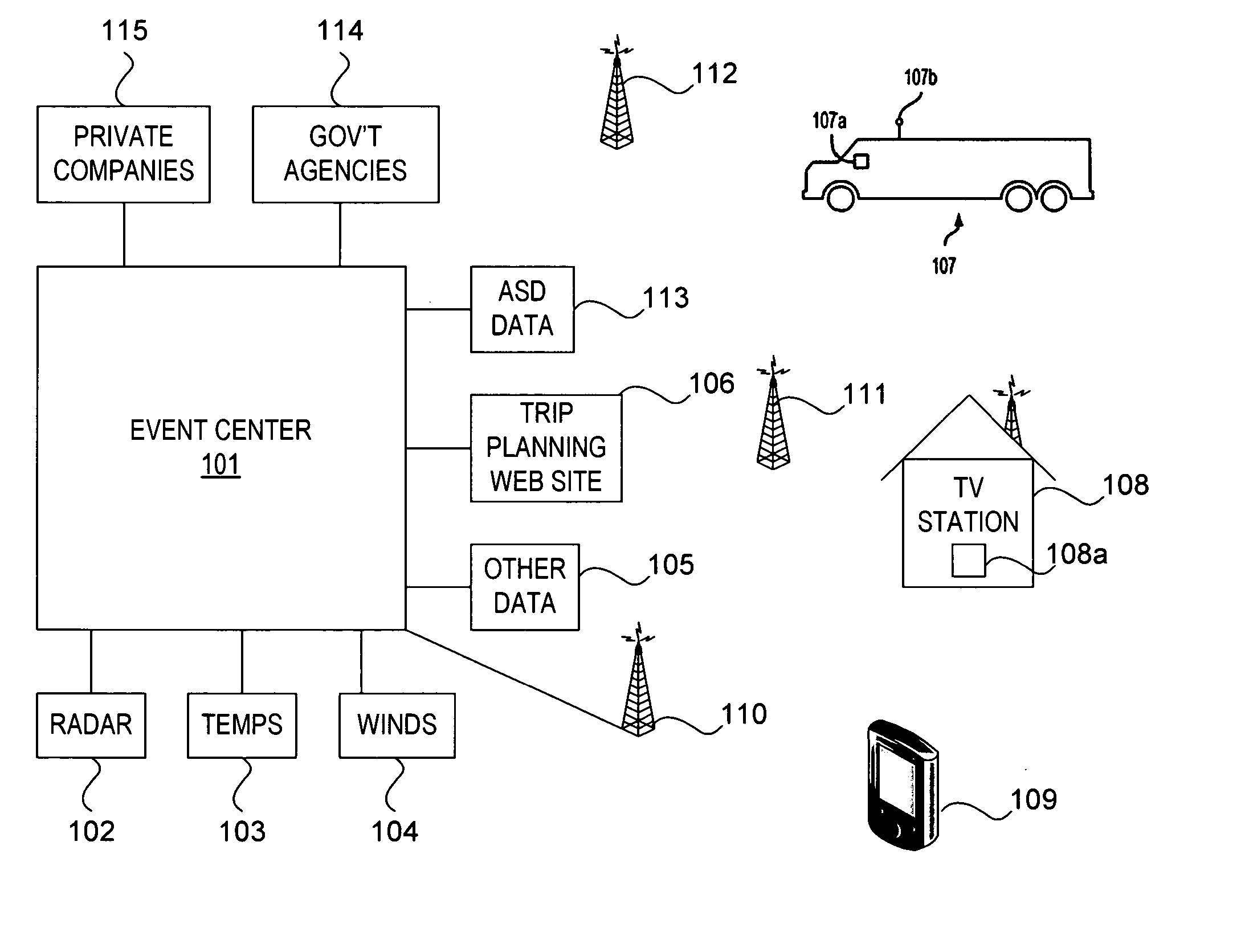
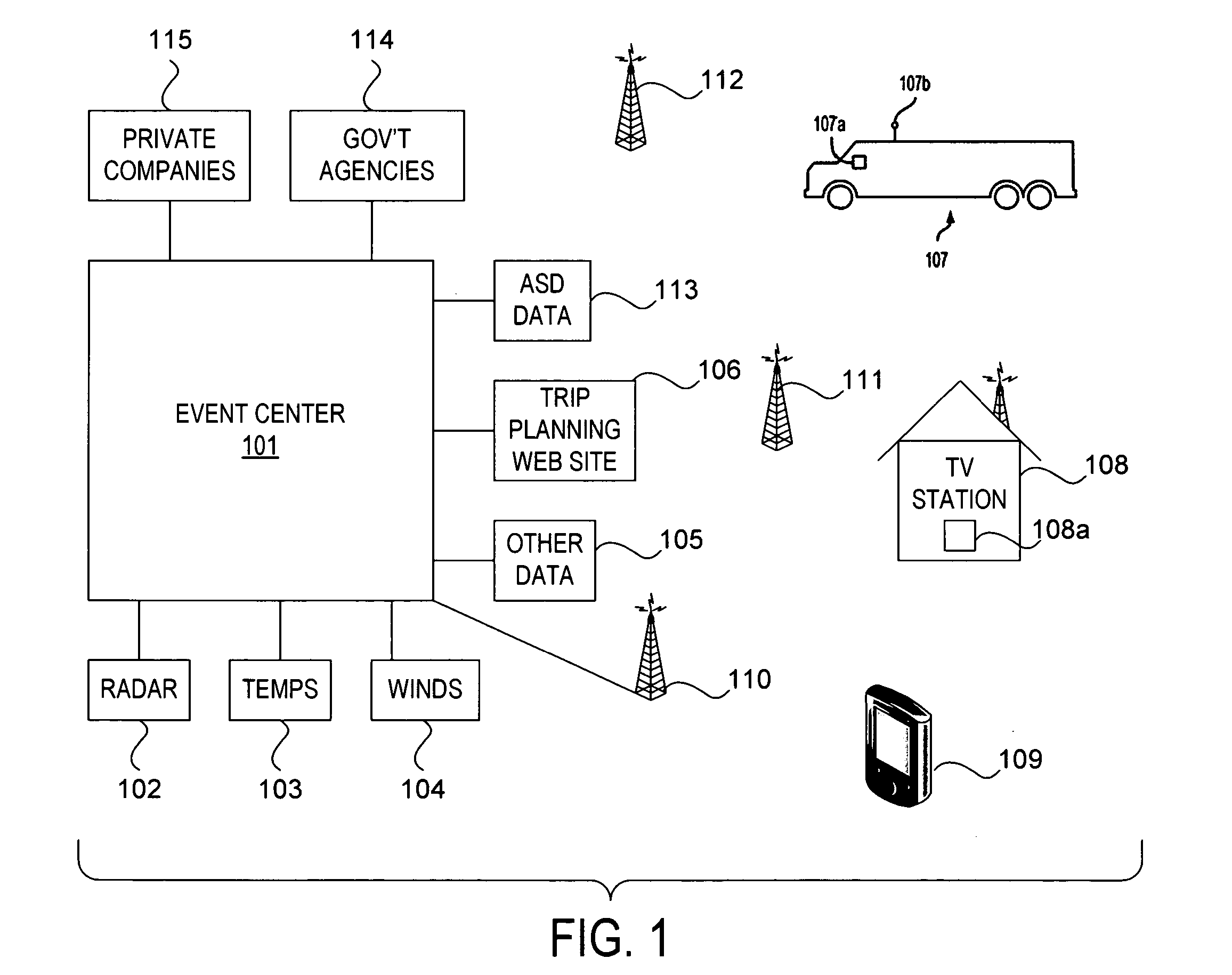
[0045]FIG. 1 shows a system employing various principles of the present invention. As shown in FIG. 1, an event center 101 receives event-related information from various sources, such as weather-related information from one or more radar sources 102, temperature data sources 103, wind data sources 104, and other data sources 105 (including, but not limited to, regional weather stations that provide air and pavement temperature, humidity, and other measurements). One or more antennas 110 coupled to weather center 101 may receive information regarding the location of mobile devices that use the system. In addition to or instead of radio frequency communication, this information can be received over the Internet, wireless network, or other computer network, or via dedicated dial-up telephone lines. Additionally, Aircraft Situation Display (ASD) data 113 can be received from various sources, such as the FAA, which distributes information regarding the current location and identity of a...


PUM


Abstract

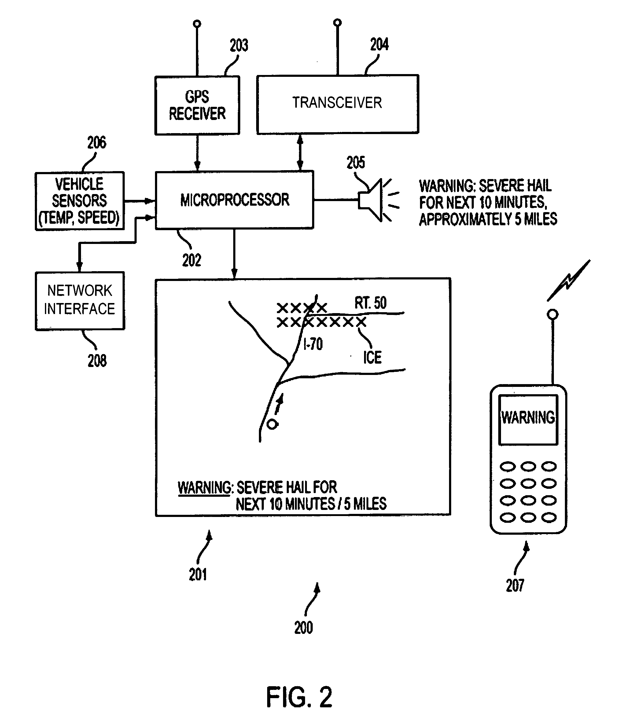
The invention provides a system and method for receiving hazard and event information in a mobile unit and using that information to warn a user of an event or future hazard with reference to the mobile unit's location and / or intended direction of travel. A hazard location algorithm compares a forecast location of each mobile unit with a forecast hazard and transmits a warning to each mobile unit that is predicted to encounter the hazard. As the mobile unit moves, its actual position is updated in an event center, and a revised warning is transmitted to the mobile unit as applicable. Warnings include audio warnings for playback and / or visual warnings for display on the mobile device. Users may also wirelessly report events or hazards to a central server in an event center by sending data to the event center via a wireless communications network. Secondary information may be included, based on the selected event type.

Description

CROSS-REFERENCE TO RELATED CASES [0001] The present application is a continuation of co-pending application Ser. No. 11 / 024,979, titled User-Centric Event Reporting, and filed Dec. 30, 2004, which is a continuation-in-part of application Ser. No. 10 / 969,915, filed Oct. 22, 2004, entitled User-Centric Event Reporting, which is a continuation of application Ser. No. 10 / 386,437, filed Mar. 13, 2003, entitled Rotating Map And User-Centric Weather Prediction.FIELD OF THE INVENTION [0002] The present invention relates generally to hazard and event warning systems. More particularly, the invention provides a method and apparatus for receiving event and / or hazard information by a portable electronic device and using that information to warn a device operator of a future event or hazard with respect to the specific device's location, and also provide the device operator with the ability to report event or hazard information to a server for further distribution. BACKGROUND OF THE INVENTION [0...

Claims


Application Information

Patent Timeline
Patent Type & Authority Applications(United States)
IPC IPC(8): G06F15/00G08B21/10G08B27/00
CPCG08B21/10G08B27/006G08G1/0962G08G1/096811Y10S128/903G08G1/20H04W4/02H04W64/00G08G1/096844H04W4/024H04W4/029
Inventor SMITH, MICHAEL R.O'NEIL, PERRY JAY
Owner USER CENTRIC IP LP
Learn More