
Analogue technology for imaging spectrograph remote-sensing image in satellite

An imaging spectrometer and remote sensing image technology, applied in the direction of instruments, re-radiation of electromagnetic waves, utilization of re-radiation, etc., can solve problems such as the impact of simulation accuracy, and achieve the effect of increasing perceptual knowledge, increasing perceptual knowledge, and avoiding the amount of calculation.

Inactive Publication Date: 2006-05-24
牛铮 +1
View PDF0 Cites 11 Cited by
  • Summary
  • Abstract
  • Description
  • Claims
  • Application Information

AI Technical Summary

Problems solved by technology

However, the data provided by various data sources are approximate descriptions of the natural surface, and there are inevitable differences with the actual natural conditions. Therefore, how to select an appropriate data source has an important impact on the simulation accuracy.

Method used


Image

  • Analogue technology for imaging spectrograph remote-sensing image in satellite
  • Analogue technology for imaging spectrograph remote-sensing image in satellite
  • Analogue technology for imaging spectrograph remote-sensing image in satellite

Examples


Embodiment Construction

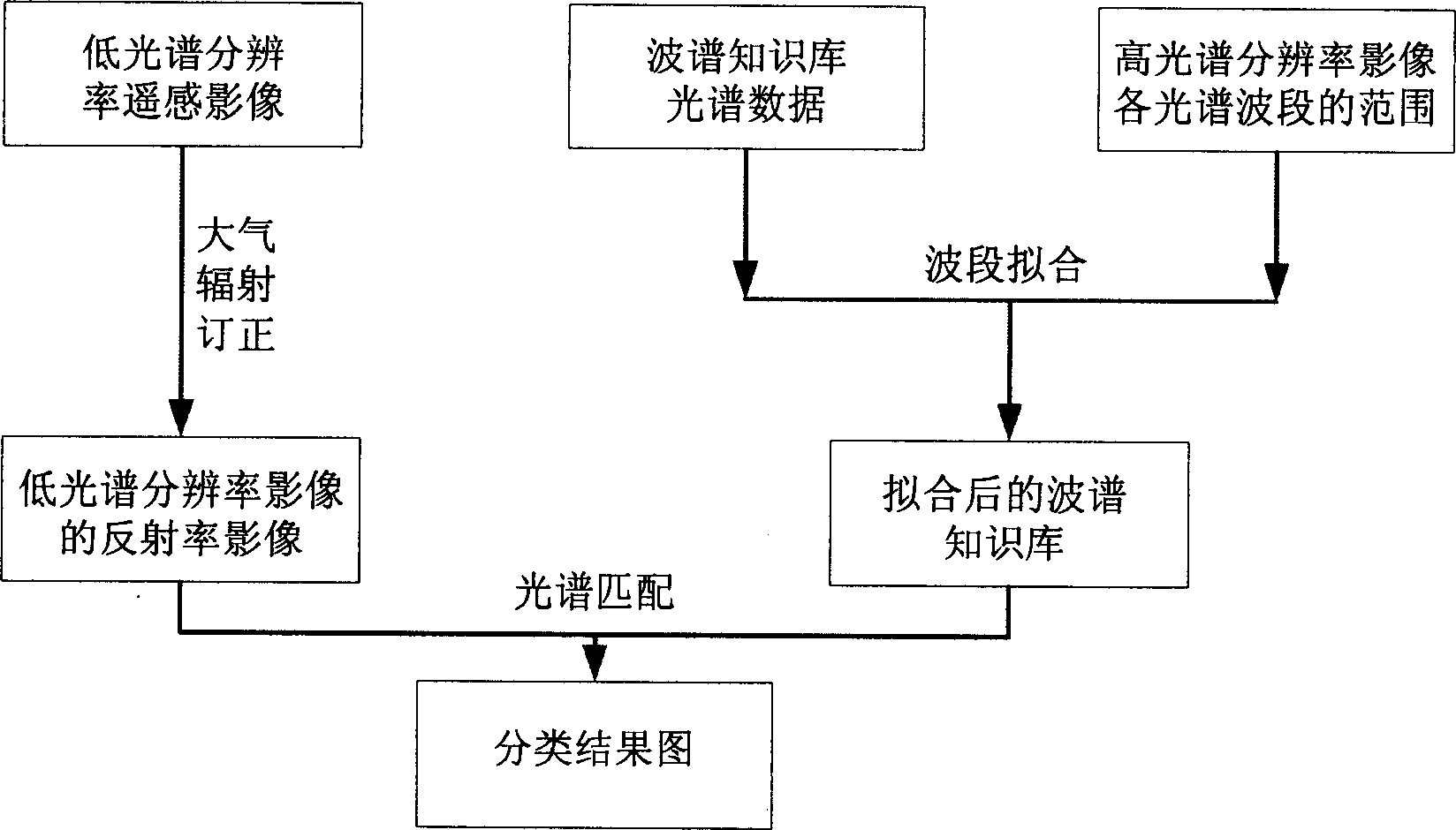
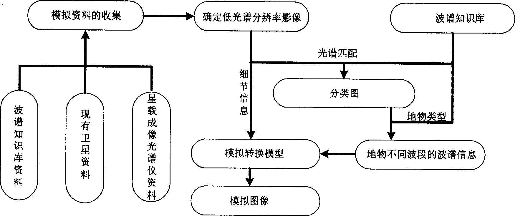
[0009] Such as figure 2 As shown, the present invention proposes a simulation technology for remote sensing images of spaceborne imaging spectrometers, including: collection of simulation data; determination of low spectral resolution remote sensing images as templates; data processing of spectral knowledge base; classification of low spectral resolution remote sensing images Acquisition of maps; acquisition of multi-band reflectance of each pixel point; construction of conversion model to obtain reflectance images of each spectral band of hyperspectral resolution images.

[0010] The complete technical process is as follows:

[0011] ●Collection of simulation data.

[0012] It consists of three parts: the spectral knowledge base that can provide detailed reflectance information of each spectral band range of high spectral resolution images, the data information of each spectral band of low spectral resolution images obtained from existing remote sensing images, and the spac...


PUM


Abstract

Based on support of prior knowledge such as spectra database, using calculation for simulating radioactive transfer in time of remote sensing imaging, the invention obtains simulated remote sensing images in each range of spectral band of remote sensing images in high spectral resolution on basis of image texture information and field information provided remote sensing data in low spectral resolution. Moreover, the invention avoids difficult acceptant amount of calculation. Before satellite emission or on-board examination, the simulated images can be viewed so that it is useful for decision maker to select proper operating mode and parameter. The invention can also be used for researching mechanism of electromagnetic transmission in procedure for capturing remote sensing image.

Description

technical field [0001] The invention is a practical technology in the field of earth observation and a new optical remote sensing image simulation technology. The invention can provide required simulated images before satellite launch or airborne test, guide the selection of the working mode and parameters of remote sensing sensors; increase the perceptual knowledge of decision makers before sensor development and satellite launch; help to make up for the lack of remote sensing databases. In general, the present invention is a practical information support technology. Background technique [0002] Remote sensing has the ability of global observation, which enables scientists to obtain multi-spatial resolution and multi-spectral resolution earth observation images, so as to better carry out the research work of earth science. In order to meet the needs of different researches, it is often hoped to obtain remote sensing images reflecting different spatial, spectral and tempor...

Claims


Application Information

Patent Timeline
IPC IPC(8): G01S17/89
Inventor 牛铮陈方
Owner 牛铮
Learn More