Method of describing and querying geographical position

A technology of geographic location and map, applied in electrical digital data processing, special data processing applications, instruments, etc., can solve the problems of computing power and wireless transmission rate that are difficult to achieve practical results, and cannot realize real-time information description and query use.

Inactive Publication Date: 2005-11-16
肖宁
View PDF0 Cites 4 Cited by
  • Summary
  • Abstract
  • Description
  • Claims
  • Application Information

AI Technical Summary

Problems solved by technology

[0010] 1. When querying geographic information, it is often necessary to transmit a large amount of data that has nothing to do with the purpose of use;
[0011] 2. Real-time description and query of information at a specific location cannot be realized
[0012] For the geographical location description and query of spatial entities executed by handheld mobile devices, it is difficult to achieve practical results due to the limitation of computing power and wireless transmission rate

Method used


Image

  • Method of describing and querying geographical position
  • Method of describing and querying geographical position
  • Method of describing and querying geographical position

Examples


specific Embodiment approach

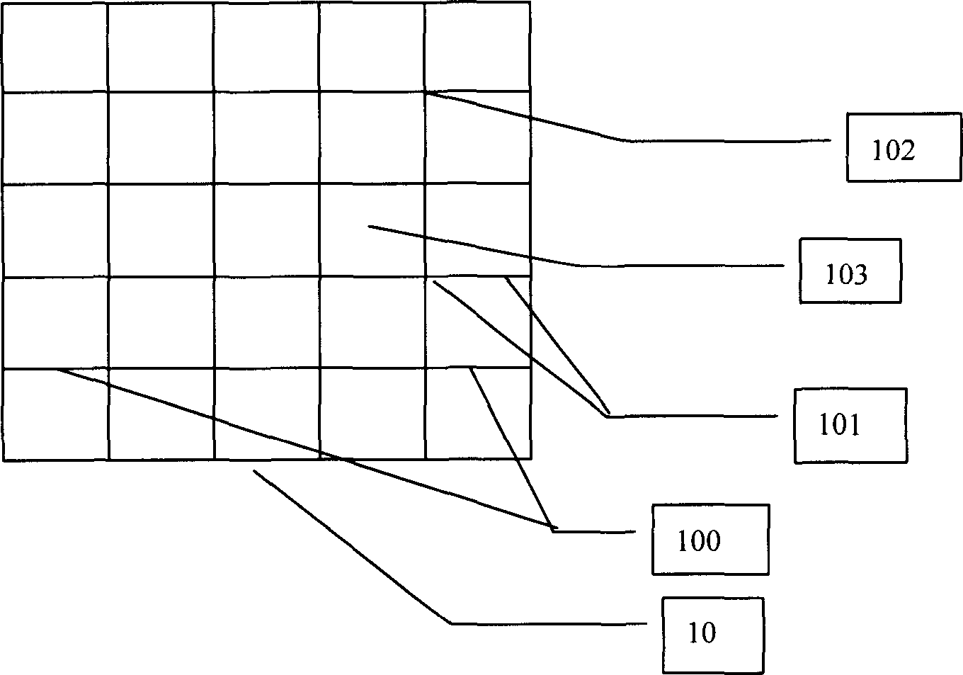
[0042] Figure 7 The network topology structure of this kind of implementation is described, and the mobile phone 301 / 302, portable computer 303, and personal digital assistant device PDA304 in the wireless communication network can use short messages to transmit point-to-point similar maps describing the geographic location of spatial entities; Figure 8 is a flowchart of this implementation. Take the geographic location of the State Intellectual Property Office as an example:

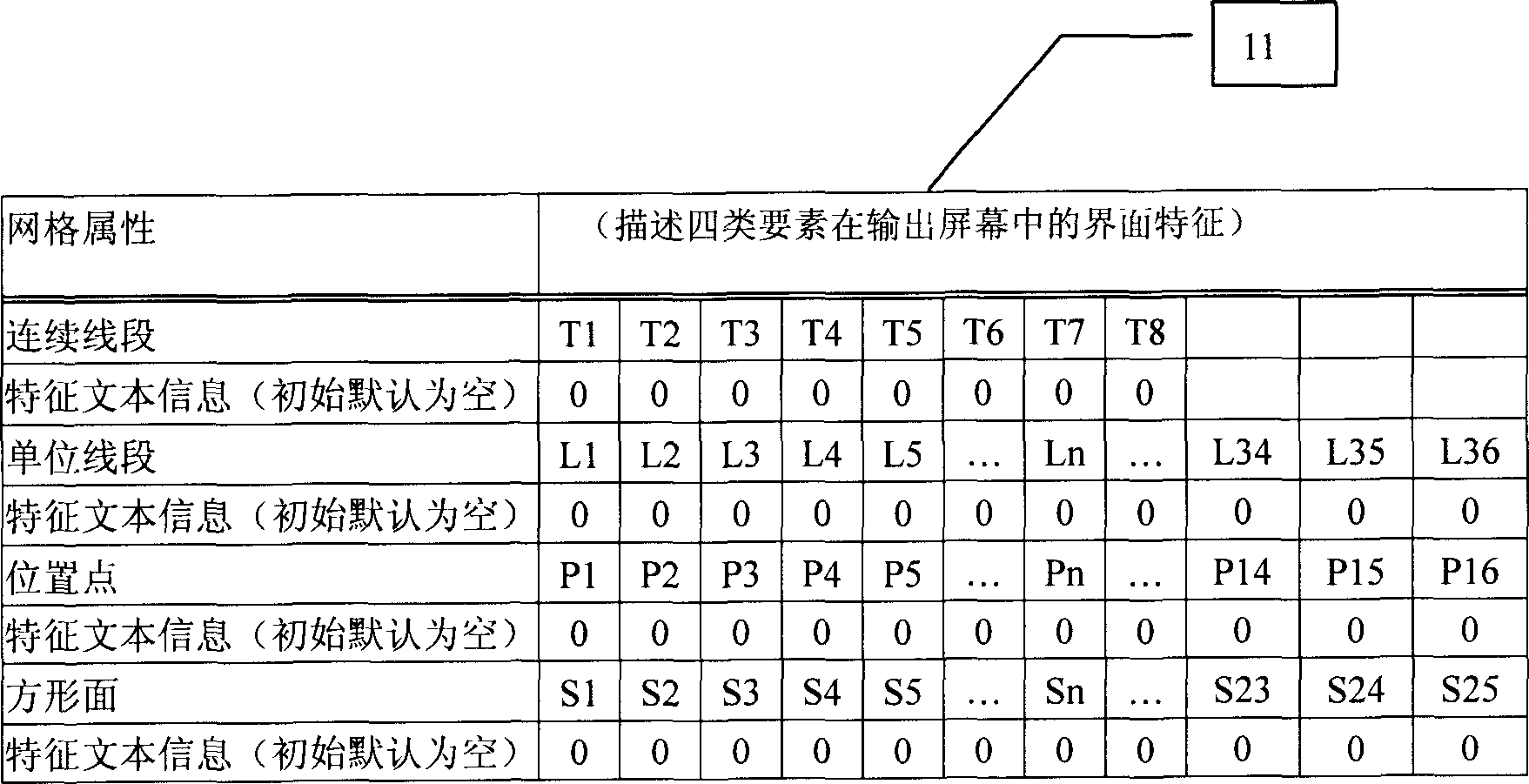
[0043] Step 1: The information provider sequentially inputs geographic feature text information on the computing device. Select two continuous line segments, two unit line segments, one location point, and one square surface as the geographic location description object and input the associated feature text information in sequence.

[0044] Continuous line segment 200: Xueyuan Road; continuous line segment 201: North Third Ring Road

[0045] Unit line segment 201(1): Lenovo Bridge; unit line segmen...


PUM


Abstract

A method for describing and inquiring geographical position includes utilizing mesh output boundary of computer to form similar map for reflecting geographical position of entity space by feature text information integrated with element of line section, unit line, dot, square face, etc; using computer to make access of map data processing centre on network for achieving inquiry and storage of similar map information and using mobile computer to transmit similar map by short message SMS or EMS or MMS.

Description

technical field [0001] The present invention relates to a method for describing and querying the geographic location of a spatial entity realized by a computing device. It utilizes the grid graphics output by the database in the computing device, and is composed of continuous line segments, unit line segments, points, square surfaces, etc. in the grid. Similar map graphics composed of elements and characteristic text information associated with each element reflect the geographic location information of spatial entities; real-time transmission of similar maps through mobile computing devices in the form of short message SMS or EMS or MMS; access to map information data in the network through computing devices The processing center realizes the query and use of similar map information. Background technique [0002] The widely used geographic information description method for spatial entities is Geographic Information System (GIS), which uses the binary data inside the comput...

Claims


Application Information

Patent Timeline
Patent Type & Authority Applications(China)
IPC IPC(8): G06F17/30
Inventor 肖宁
Owner 肖宁
Why Eureka
Try Eureka