Geographic information analysis method and system supporting multiple data sources

A geographic information and multi-data source technology, applied in the field of geographic information analysis, can solve problems such as few data sources and does not support custom data sources, etc., and achieve the effect of efficiently querying data

Active Publication Date: 2022-05-13
国家电投集团雄安能源有限公司 +1
View PDF12 Cites 0 Cited by
  • Summary
  • Abstract
  • Description
  • Claims
  • Application Information

AI Technical Summary

Problems solved by technology

At present, the geographic information analysis system on the market is mainly based on geoserver, but geoserver has a lot of shortcomings: firstly, geoserver supports fewer data sources, and secondly, when publishing raster data through the system, it can only read data from the local; publishing vector data Only a few data sources such as cassandra / greenplum are supported, and custom data sources are not supported

Method used


Image

  • Geographic information analysis method and system supporting multiple data sources
  • Geographic information analysis method and system supporting multiple data sources
  • Geographic information analysis method and system supporting multiple data sources

Examples


Embodiment

[0042] refer to Figure 1-2 As shown, the present embodiment provides a geographic information analysis method and system supporting multiple data sources, and the method includes the following steps:

[0043] Step S1-1 is, Geoserver receives the ogc service request, stores the meta information of the ogc request, and uses the meta information to perform ogc service preview;

[0044] Step S1-2 is to obtain the spatio-temporal geographic information data required for the service from the data source according to the ogc service request;

[0045] Step S1-3 is to perform information analysis according to the spatiotemporal geographic information data.

[0046] Preferably, the meta information includes: service type, data type and data information.

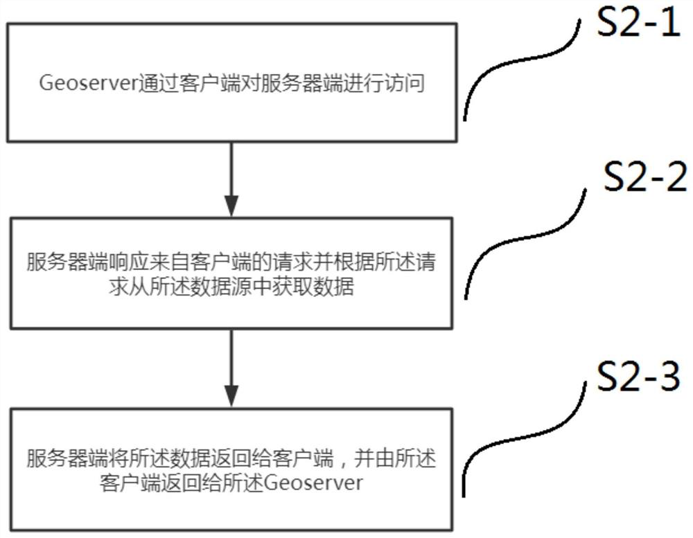
[0047] Preferably, obtaining the spatio-temporal geographic information data required by the service includes the following steps:

[0048] Step S2-1 is, the Geoserver accesses the server through the client;

[0049] Step S2-2 is, t...


PUM


Abstract

The invention discloses a geographic information analysis method and system supporting multiple data sources, and the method comprises the following steps: a Geoserver receives an ogc service request, stores the meta-information of the ogc request, and carries out the ogc service preview through the meta-information; according to the ogc service request, obtaining space-time geographic information data required by the service from a data source; and performing information analysis according to the space-time geographic information data. The method and the system provided by the invention can support more common data sources on the market, and can support release of vector data and remote release of raster data.

Description

technical field [0001] The invention belongs to the field of geographic information analysis, and in particular to a geographic information analysis method and system supporting multiple data sources. Background technique [0002] Geographic information analysis system is based on geospatial data, adopts geographic model analysis method, timely provides a variety of spatial and dynamic geographic information, and collects, stores, analyzes and visualizes various geospatial information. Computer technology systems for geographic research and geographic decision-making. [0003] The main function of the geographic information analysis system is to be able to read different types of data from various data sources (local and remote), and then publish them into layer services for visual display. At present, the geographic information analysis system on the market is mainly based on geoserver, but geoserver has a lot of shortcomings: firstly, geoserver supports fewer data sources...

Claims


Application Information

Patent Timeline
Patent Type & Authority Applications(China)
IPC IPC(8): G06F16/9537H04L67/01H04L67/51
CPCG06F16/9537
Inventor 王志洁马骁马志军何子峰朱军张荣达冯博羽李亚鑫
Owner 国家电投集团雄安能源有限公司
Why Eureka
Try Eureka