Terrain pyramid celestial body surface illumination simulation method and system

A simulation method and pyramid technology, applied in the field of image simulation, can solve problems such as high-resolution terrain data processing, waste, and the impact of human lunar exploration site selection, and achieve high temporal and spatial resolution and long-term effects.

Pending Publication Date: 2022-04-19
TONGJI UNIV
View PDF0 Cites 0 Cited by
  • Summary
  • Abstract
  • Description
  • Claims
  • Application Information

AI Technical Summary

Problems solved by technology

However, the traditional horizon method model is difficult to process high-resolution terrain data, the main reason is that the calculation density of the horizon database generation link will increase sharply with the increase of terrain resolution
Therefore, the current international highest resolution for simulating the long-term illumination conditions on the lunar surface stays at 20 meters for a long time, and it is difficult to continue to improve (even if ESA uses a large computer cluster network)
This is a great waste for the current LOLA data with a terrain resolution of 5 meters, the LRO data with an image resolution of 0.5 meters, and the higher-precision terrain data that humans may obtain in the future. siting can have a considerable impact on
[0003] To sum up, predecessors have done a lot of research on illumination simulation and analysis methods with high temporal and spatial resolution on the lunar surface, but they have not been able to achieve the highest level of accuracy in the application scenarios with long time span and high temporal resolution. High-precision illumination simulation and analysis with the same resolution of terrain data

Method used


Image

  • Terrain pyramid celestial body surface illumination simulation method and system
  • Terrain pyramid celestial body surface illumination simulation method and system
  • Terrain pyramid celestial body surface illumination simulation method and system

Examples


Embodiment Construction

[0050] The present invention will be described in detail below in conjunction with the accompanying drawings and specific embodiments. This embodiment is carried out on the premise of the technical solution of the present invention, and detailed implementation and specific operation process are given, but the protection scope of the present invention is not limited to the following embodiments.

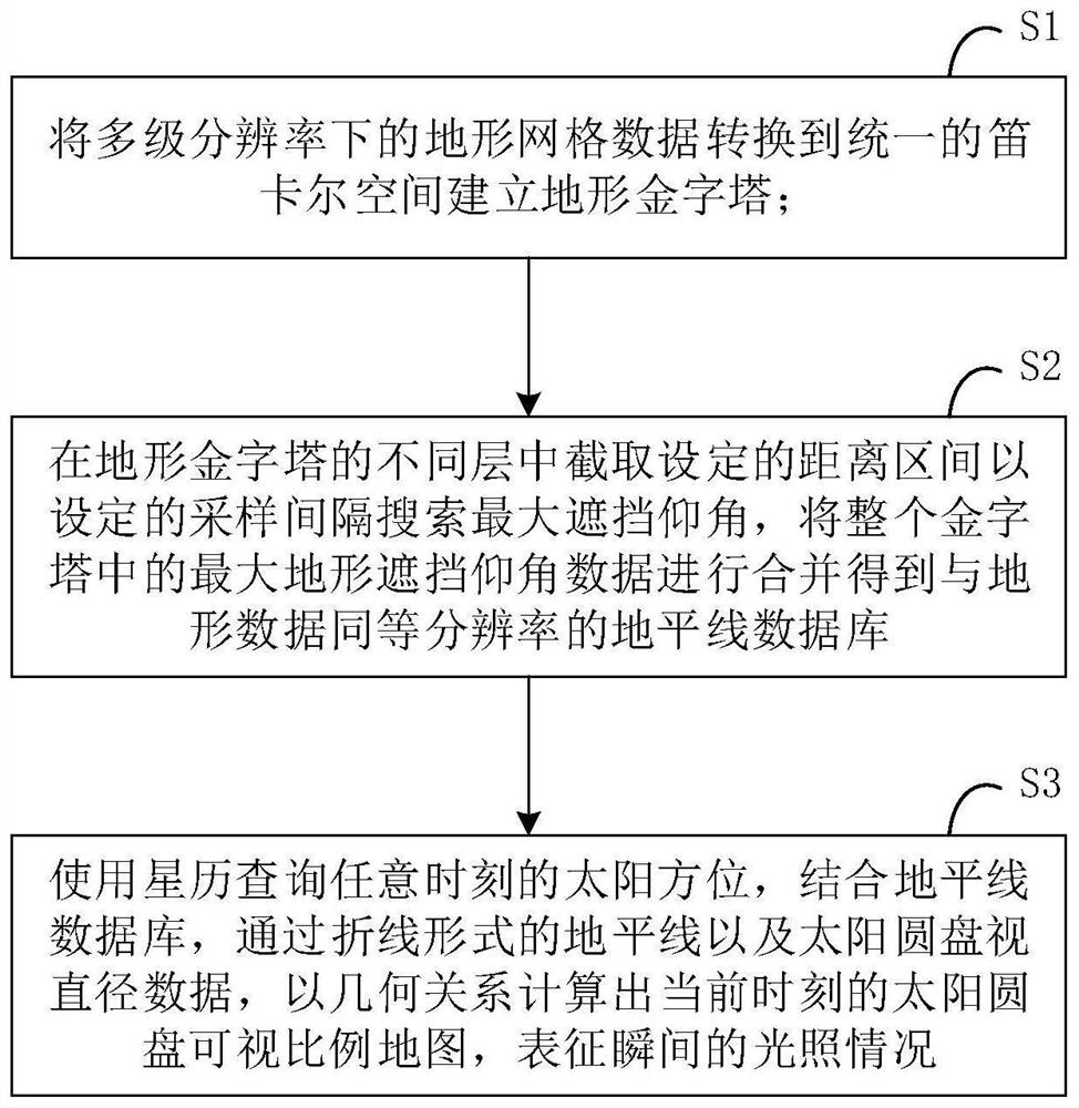
[0051] This embodiment provides a topographic pyramid celestial body surface illumination simulation method with a spatial resolution of 5 meters, which mainly includes the following aspects:

[0052] (1) Establishment of terrain pyramids in Cartesian space

[0053] Define the origin and axis of the space, redefine the elevation direction, back-project the multi-resolution terrain raster data into a three-grid vector in Cartesian space, and perform topology reconstruction.

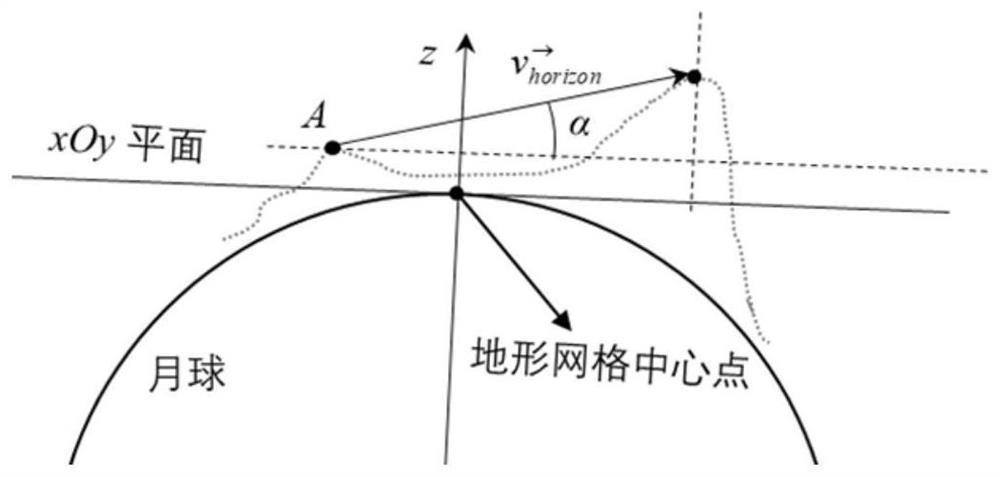
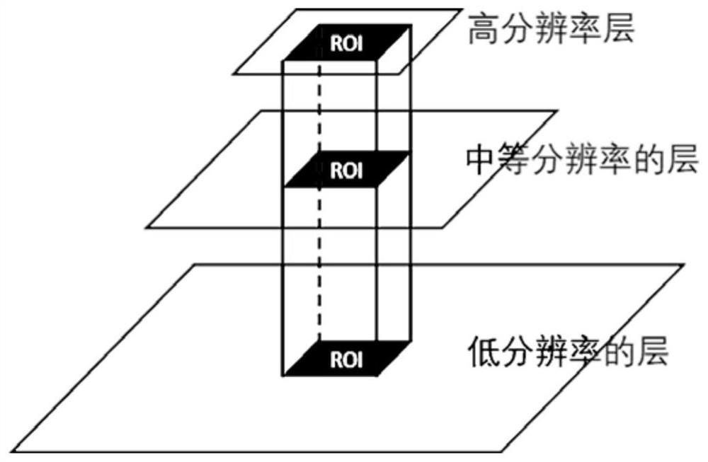
[0054] (2) Calculation of horizon database

[0055] Set a reasonable sampling frequency according to the dist...


PUM


Abstract

The invention relates to a terrain pyramid celestial body surface illumination simulation method and a terrain pyramid celestial body surface illumination simulation system. The terrain pyramid celestial body surface illumination simulation method comprises the following steps: converting terrain grid data under multi-level resolutions into a unified Cartesian space to establish a terrain pyramid; set distance intervals are intercepted in different layers of the terrain pyramid, maximum shielding elevation angles are searched at set sampling intervals, and maximum terrain shielding elevation angle data in the whole pyramid are combined to obtain a horizon line database with the same resolution as terrain data; the solar azimuth at any moment is inquired by using an ephemeris, and a solar disc visual proportion map at the current moment is calculated by combining a horizon line database and through a broken line type horizon line and solar disc visual diameter data according to a geometrical relationship, so that the instantaneous illumination condition is represented. Compared with the prior art, the method has the advantages that higher-precision, higher-temporal-spatial-resolution and long-time-span illumination simulation on the surface of the moon can be realized more quickly with less computing resources consumed.

Description

technical field [0001] The invention relates to the field of image simulation, in particular to a surface illumination simulation method of a topographic pyramid celestial body. Background technique [0002] Sunlight is the main energy source for landers and rovers in lunar exploration activities, and it also affects the thermal state and geological processes of the moon. Accurate illumination prediction and analysis is a necessary preparation for lunar surface exploration activities, and its accuracy and resolution are extremely important for lunar landing and scientific research station site selection. Traditional lighting simulation methods include ray tracing and horizon methods. Among them, the ray tracing method is to directly calculate the Boolean visibility of each transient state between the star surface point and the light source point on the basis of establishing the solar system celestial body orbit model. The representative product is NASA's IllumNG system. Al...

Claims


Application Information

Patent Timeline
Patent Type & Authority Applications(China)
IPC IPC(8): G06T15/06G06T17/05G06T17/20
CPCG06T17/05G06T17/20G06T15/06
Inventor 童小华黄潜刘世杰叶真金雁敏谢欢许雄冯永玖
Owner TONGJI UNIV
Why Eureka
Try Eureka