Point distribution method for observing geogas interaction process of alpine lake

A lake and earth-atmosphere technology, which is applied in the field of observing the interaction process of alpine lakes and earth-atmosphere, can solve the problems of poor representativeness of observation results, lack of scientific planning, strong randomness of observation points, etc., and achieves high correlation and good Applicability and scalability, capital cost and labor cost savings

Pending Publication Date: 2022-04-05
NORTHWEST INST OF ECO-ENVIRONMENT & RESOURCES CAS
View PDF3 Cites 0 Cited by
  • Summary
  • Abstract
  • Description
  • Claims
  • Application Information

AI Technical Summary

Problems solved by technology

With the rapid development of satellite remote sensing technology, satellite remote sensing technology has been used to observe the evolution of plateau lake area, evaporation and water balance in recent years. However, due to the lack of ground verification data, the causes of some lake changes are still not clear. Regional water cycle and climate impacts are still poorly understood (see figure 2 )
At present, although some observation facilities for the interaction between the lake and the atmosphere on the Qinghai-Tibet Plateau have been established, most of these facilities are limited to a single site, lacking global multi-scale observations of the lake and its surroundings, and the setting of observation points is relatively random, and lacks rigorous and careful planning beforehand. scientific planning, making the observations less representative

Method used


Image

  • Point distribution method for observing geogas interaction process of alpine lake
  • Point distribution method for observing geogas interaction process of alpine lake
  • Point distribution method for observing geogas interaction process of alpine lake

Examples


Embodiment Construction

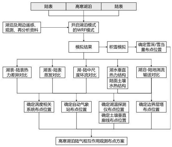
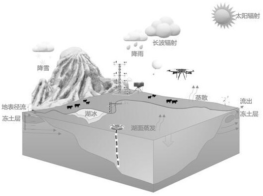
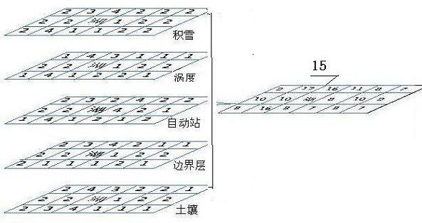
[0029] The present invention uses the reanalysis data to drive the mesoscale weather forecast model (WRF) with lake model, carries out the simulation of the interaction process of the alpine lake and the earth atmosphere, and uses the model simulation results combined with satellite remote sensing products to analyze the regional snow cover, lake surface-land surface heat The difference in evaporation between the lake surface and the land surface, the mesoscale circulation of the lake surface and the surrounding land, the vertical thermal structure of the lake, the hydrothermal process of the soil on the lakeside land surface, and the comparison of turbulent transport processes were analyzed to obtain highly sensitive areas of different variables. Using the spatial overlay analysis technology of geographic information system, superimpose to obtain the optimal site combination of various observation points in the lake area, combined with field survey, traffic accessibility, wirel...


PUM


Abstract

The invention relates to a point distribution method for observing a geogas interaction process of a high and cold lake. According to the method, based on a mode simulation result and a remote sensing product, regional accumulated snow thickness and spatial distribution, lake surface and land surface thermal difference, lake surface and land surface evaporation difference, a lake and land wind mesoscale circulation system, a lake water vertical thermal structure, surrounding land soil hydrothermal characteristics, lake and land turbulence conveying difference and the like are analyzed and determined; the method comprises the following steps of: determining sensitive areas influencing the atmospheric interaction of the high and cold lake, and carrying out observation station layout in the geogas interaction process of the lake basin by combining the sensitive areas with a geographic information system spatial analysis method, so as to form a whole set of monitoring station layout combining numerical mode simulation analysis, satellite remote sensing observation and field reconnaissance. The technical scheme is novel, the selected point representativeness is high, technical support can be provided for geogas interaction observation of lakes in other areas, and the method is easy to popularize.

Description

technical field [0001] The invention relates to the field of observation of the earth-atmosphere interaction process. Specifically, it refers to a point layout method for observing the process of earth-atmosphere interaction in alpine lakes. This method proposes a method based on the model simulation results to obtain the spatial sensitivity zoning of different feature quantities and perform spatial superposition, which can quickly realize the selection of the most representative area in the lake and its surrounding areas as a way to understand and understand the lake-earth-atmosphere interaction The monitoring points are convenient for installing various observation instruments, and the observation results will provide original data support for understanding the lake-earth-atmosphere interaction process. Background technique [0002] The total area of ​​lakes on the Qinghai-Tibet Plateau exceeds 50,000 square kilometers, accounting for more than 50% of the total lake area ...

Claims


Application Information

Patent Timeline
IPC IPC(8): G06F30/20G06F111/10G06F113/08
Inventor 陈昊孟宪红李照国吕世华奥银焕赵林尚伦宇王少影文莉娟舒乐乐王婵杨文
Owner NORTHWEST INST OF ECO-ENVIRONMENT & RESOURCES CAS
Why Eureka
Try Eureka