High-precision positioning Beidou ground-based augmentation system
A ground-based augmentation system and high-precision technology, which is applied in the field of Beidou ground-based augmentation system for high-precision positioning, can solve problems such as inability to complete multi-coordinate systems, broadcast signal positioning accuracy needs to be improved, and coverage is not comprehensive, so as to improve broadcasting capabilities, Improving the level of modernization and the effect of fast service speed
- Summary
- Abstract
- Description
- Claims
- Application Information
AI Technical Summary
Problems solved by technology
Method used
Image
Examples
Embodiment 1
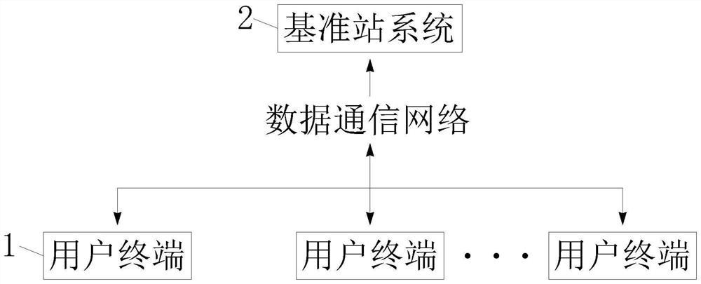
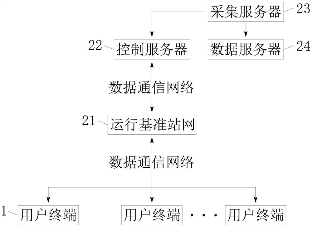
[0039] see Figure 1-3 , the present invention provides the following technical solutions: a Beidou ground-based augmentation system for high-precision positioning, including a user terminal 1 and a reference station system 2;
[0040] The user terminal 1 is a user's handheld terminal, and the user can send information through the handheld terminal to obtain the spatial information required by the user;
[0041] The user terminal 1 is connected to the reference station system 2 through the data communication network, providing users with comprehensive spatial information services;
[0042] The reference station system 2 includes an operation reference station network 21, a control server 22, an acquisition server 23 and a data server 24;
[0043] The operation reference station network 21 is connected with the user terminal 1 through the data communication network, receives the information sent by the user, and broadcasts the spatial information required by the user at the same...
Embodiment 2
[0059] The difference of this embodiment compared with embodiment 1 is:
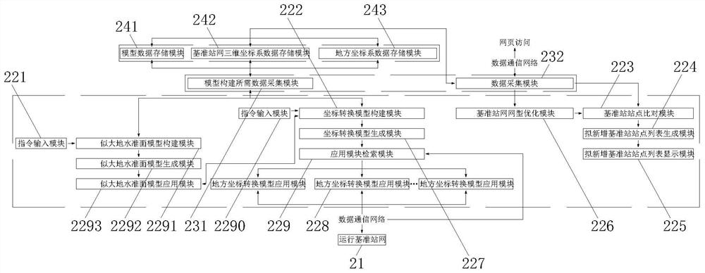
[0060] Specifically, the control server 22 also includes a first instruction input module 221, which is used to input instructions for constructing a quasi-geoid model. The first instruction input module 221 is connected with a quasi-geoid model construction module 2291, which is used to The construction of the model, the quasi-geoid model building module 2291 is connected with the quasi-geoid model generation module 2292, which is used for the generation of the quasi-geoid model, and the quasi-geoid model generation module 2292 is connected with the quasi-geoid model application module 2293, for the application of the quasi-geoid model, the quasi-geoid model application module 2293 is connected with the coordinate transformation module construction module 222, and is used to provide elevation anomalies for the construction of the local coordinate transformation model;
[0061] The quasi-geoid model cons...
Embodiment 3
[0066] The difference of this embodiment compared with embodiment 2 is:
[0067] Specifically, the control server 22 also includes a reference station network type optimization module 226, and the reference station network type optimization module 226 is connected with the data acquisition module 232 for optimizing the existing reference station network type in real time. Optimization module 226 is connected with reference station site comparison module 223, and reference station site comparison module 223 is connected with data collection module 232, is used for comparing the reference station site to be added, and reference station site comparison module 223 is connected with proposed new Increase base station site list generation module 224, be used for the list generation that plans to add base station site, plan to add base station site list generation module 224 to be connected with plan to add base station site list display module 225, be used to plan to add Display of ...
PUM
 Abstract
Description
Claims
Application Information
 - Generate Ideas
- Intellectual Property
- Life Sciences
- Materials
- Tech Scout
- Unparalleled Data Quality
- Higher Quality Content
- 60% Fewer Hallucinations
Browse by: Latest US Patents, China's latest patents, Technical Efficacy Thesaurus, Application Domain, Technology Topic, Popular Technical Reports.
© 2025 PatSnap. All rights reserved.Legal|Privacy policy|Modern Slavery Act Transparency Statement|Sitemap|About US| Contact US: help@patsnap.com


