
Space inversion method and system for space-borne remote sensing water vapor based on neural network

A neural network and water vapor technology, which is applied in the field of space inversion methods and systems for spaceborne remote sensing water vapor, can solve the problems of not expanding the space domain, unable to use the neural network algorithm PWV inversion, reducing the spatial versatility of the algorithm, etc., to improve the accuracy. Effect

Active Publication Date: 2022-04-22
SHANDONG UNIV
View PDF5 Cites 0 Cited by
  • Summary
  • Abstract
  • Description
  • Claims
  • Application Information

AI Technical Summary

Problems solved by technology

However, the inventors found that the scattered distribution of GNSS stations reduces the spatial versatility of the algorithm. The existing joint spaceborne remote sensing data and ground-based GNSS data, and the neural network algorithm based on ground-based GNSS stations are usually only in fixed GNSS stations. However, for areas without GNSS stations, the neural network algorithm cannot be used to perform accurate PWV inversion due to the lack of historical data of GNSS stations; at the same time, due to the complex land cover in space Types, especially in microwave inversion, the complexity of land cover types leads to the variability of microwave emissivity parameters, which in turn leads to the establishment of algorithms based on fixed stations are still point-domain algorithms, not extended to the space domain

Method used


Image

  • Space inversion method and system for space-borne remote sensing water vapor based on neural network
  • Space inversion method and system for space-borne remote sensing water vapor based on neural network
  • Space inversion method and system for space-borne remote sensing water vapor based on neural network

Examples


Embodiment 1

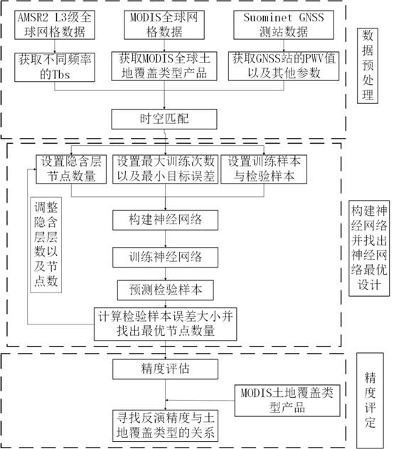
[0046]The purpose of this embodiment is to provide a neural network-based space-based remote sensing water vapor space inversion method.

[0047] A neural network-based space-borne remote sensing water vapor space retrieval method, comprising:

[0048] Obtain space-based remote sensing observation data, land cover type data and ground-based GNSS water vapor observation data;

[0049] Based on the linear interpolation algorithm, the three types of data obtained are matched in time and space globally to obtain matching data on a global scale;

[0050] Based on the location information of the area to be retrieved by water vapor and the matching data in the global scope, determine the matching data corresponding to the current location information;

[0051] The location information and its corresponding matching data are input into the pre-trained deep learning model, and the water vapor inversion result of the area to be inversed by water vapor is output.

[0052] Further, the ...

Embodiment 2

[0086] The purpose of this embodiment is to provide a neural network-based space-borne remote sensing water vapor space inversion system.

[0087] A neural network-based space-borne remote sensing water vapor space inversion system, including:

[0088] A data acquisition unit, which is used to acquire space-based remote sensing observation data, land cover type data and ground-based GNSS water vapor observation data;

[0089] A space-time matching unit, which is used to perform space-time matching on the three types of data obtained globally based on a linear interpolation algorithm to obtain matching data on a global scale;

[0090] A water vapor inversion unit, which is used to determine the matching data corresponding to the current position information based on the position information of the area to be water vapor inversion and the matching data in the global range; input the position information and the corresponding matching data into the pre-training The deep learning...


PUM


Abstract

The invention provides a neural network-based space-borne remote sensing water vapor space inversion method and system, which belongs to the technical field of water vapor inversion prediction, and the scheme includes: obtaining space-based remote sensing observation data, land cover type data, and ground-based GNSS water vapor Observational data; based on the linear interpolation algorithm, the three types of data obtained are matched globally in time and space to obtain matching data on a global scale; based on the location information of the area to be retrieved by water vapor and the matching data on a global scale, determine the current Matching data corresponding to the location information; input the location information and the corresponding matching data into the pre-trained deep learning model, and output the water vapor inversion result of the area to be water vapor inversion.

Description

technical field [0001] The invention belongs to the technical field of water vapor space inversion prediction, and in particular relates to a space-borne remote sensing water vapor space inversion method and system based on a neural network. Background technique [0002] The statements in this section merely provide background information related to the present invention and do not necessarily constitute prior art. [0003] Although a large number of neural network algorithms for PWV (Precipitable Water Vapor) inversion have been proposed and have achieved good results, most of these algorithms are obtained through such as NCEP (National Center for Environmental Prediction) and ECMEF (European Central Scale Weather Forecast Center) reanalysis data established. [0004] Ground-based GNSS (Global Navigation Satellite System) observations can provide higher accuracy and time resolution PWV values ​​at fixed stations than reanalyzed data. However, the inventors found that the ...

Claims


Application Information

Patent Timeline
Patent Type & Authority Patents(China)
IPC IPC(8): G06V20/13G06V10/774G06V10/82G06K9/62G06N3/04
CPCG06N3/045G06F18/214
Inventor 许艳高兆瑞江楠徐天河
Owner SHANDONG UNIV
Learn More