Large-scale remote sensing image-based hangar recognition method
A remote sensing image and recognition method technology, applied in the field of image processing, can solve the problems of reducing cost and low accuracy, and achieve the effects of reducing cost, improving versatility, and improving detection timeliness
- Summary
- Abstract
- Description
- Claims
- Application Information
AI Technical Summary
Problems solved by technology
Method used
Image
Examples
Embodiment Construction
[0051] The present invention will be further described below in conjunction with the accompanying drawings and embodiments. This figure is a simplified schematic diagram, which only schematically illustrates the basic structure of the present invention, so it only shows the structures related to the present invention.
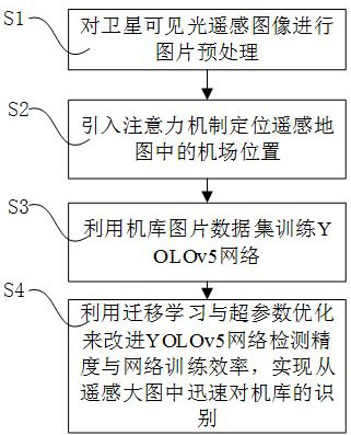
[0052] Such as figure 1 As shown, a hangar recognition method based on large-scale remote sensing images includes the following steps:
[0053] S1. Perform image preprocessing on satellite visible light remote sensing images;
[0054] In this embodiment, the large-scale satellite visible light remote sensing original image of a certain ground image is obtained, and the large-scale points in the image are selected by the nearest neighbor point method, and then down-sampled and binarized, and the above-mentioned two-step processing is performed The image is divided into multiple small-scale images and labeled, and the image labels of the corresponding positions ...
PUM
 Abstract
Description
Claims
Application Information
 - R&D
- Intellectual Property
- Life Sciences
- Materials
- Tech Scout
- Unparalleled Data Quality
- Higher Quality Content
- 60% Fewer Hallucinations
Browse by: Latest US Patents, China's latest patents, Technical Efficacy Thesaurus, Application Domain, Technology Topic, Popular Technical Reports.
© 2025 PatSnap. All rights reserved.Legal|Privacy policy|Modern Slavery Act Transparency Statement|Sitemap|About US| Contact US: help@patsnap.com


