


Quick Research
Generate reliable direction feasibility study reports for your R&D in just a few steps.

Technical Q&A
Discover and master advanced knowledge NOW. Basics, ideas, possibilities, all at once.

Find Solutions
As an expert in R&D theories, this can generate solutions to your technical problems instantly.

Evaluate Feasibility
Analyze your overall solution with one click, know your potential R&D risks in advance.

Monitor Landscape
Get weekly tech updates, stay abreast of the latest tech innovations and key insights.
Method, system and device for organizing, storing and retrieving multi-source satellite split-view image data
An image data and satellite technology, applied in the field of satellite remote sensing image information system, can solve the problems of large amount of calculation, low efficiency of data organization storage and retrieval, huge amount of metadata in the image metadata table, etc., to achieve small amount of data calculation, High efficiency of data organization and storage, and the effect of narrowing the scope of retrieval
- Summary
- Abstract
- Description
- Claims
- Application Information
AI Technical Summary
Problems solved by technology
Method used
Image

Examples
Embodiment 1
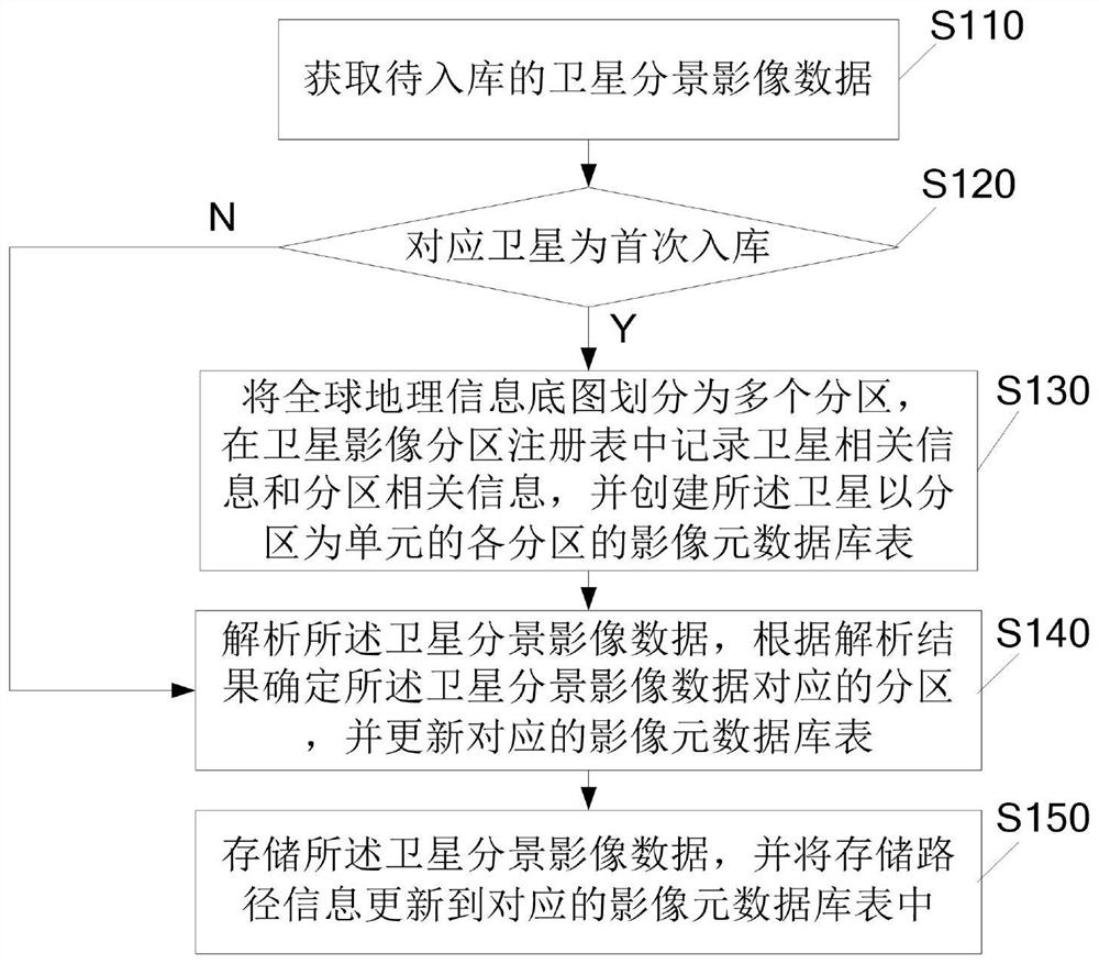
[0021] figure 1 It is a flowchart of a method for organizing and storing multi-source satellite scene image data according to Embodiment 1 of the present invention. Such as figure 1 As shown, the method includes:
[0022] S110, acquiring the satellite sub-view image data to be put into storage.
[0023] A scene image entity file of satellite split-view image data is usually combined with corresponding auxiliary image files. The auxiliary image file can include spatial information (that is, image coverage spatial graphics) and attribute information of satellite split-view image data, image entity file and spatial information One-to-one correspondence with attribute information.
[0024] S120, judging whether the satellite corresponding to the satellite sub-view image data is stored for the first time, if so, execute S130, otherwise execute S140;
[0025] Specifically, the judgment can be made according to the attribute information in the image auxiliary file of the satellit...
Embodiment 2
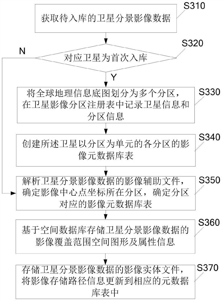
[0038] image 3 It is a flowchart of a method for organizing and storing multi-source satellite scene image data according to Embodiment 2 of the present invention. Such as image 3 As shown, the method includes:
[0039] S310, acquiring satellite sub-view image data to be put into storage;
[0040] S320, judging whether the satellite corresponding to the satellite sub-view image data is put into storage for the first time, if yes, execute S330, otherwise execute S350;
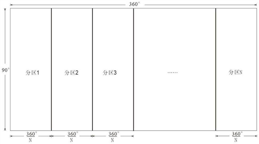
[0041] S330, using the global satellite image data partition model to divide the global geographic information base map into multiple partitions, and recording satellite information and partition information in the satellite image partition registry;
[0042] S340, based on the spatial database, create an image metadata database table for each partition of the satellite in a partition unit;
[0043] S350, analyzing the image auxiliary file of the satellite sub-view image data, determining the partition whe...
Embodiment 3
[0048] Such as Figure 4 As shown, the multi-source satellite image data organization and storage system 400 includes a data acquisition module 410 , a database table management module 420 , a metadata storage module 430 and an image data storage module 440 . The data acquisition module 410 is used to obtain the satellite split-view image data to be stored in the warehouse; the database table management module 420 is used to use the global satellite image data partition model to divide the global The geographic information base map is divided into multiple partitions, the satellite information and partition information are recorded in the satellite image partition registry, and the image metadata table of each partition of the satellite is created based on the spatial database, and the image database table Store the metadata of the satellite split-view image data in the satellite corresponding partition; the metadata storage module 430 is used to analyze the satellite split-vi...
PUM
 Abstract
Description
Claims
Application Information
 - R&D Engineer
- R&D Manager
- IP Professional
- Industry Leading Data Capabilities
- Powerful AI technology
- Patent DNA Extraction
Browse by: Latest US Patents, China's latest patents, Technical Efficacy Thesaurus, Application Domain, Technology Topic, Popular Technical Reports.
© 2024 PatSnap. All rights reserved.Legal|Privacy policy|Modern Slavery Act Transparency Statement|Sitemap|About US| Contact US: help@patsnap.com