
Target detection method for large-size aerial remote sensing image

A technology for aerial remote sensing and target detection, applied in the field of target detection, can solve problems such as lack of context information, and achieve the effect of alleviating the lack of context information, widening the scope of application, and ensuring reliability.

Pending Publication Date: 2022-01-28
EAST CHINA NORMAL UNIV
View PDF0 Cites 2 Cited by
  • Summary
  • Abstract
  • Description
  • Claims
  • Application Information

AI Technical Summary

Problems solved by technology

[0006] Aiming at the problem of missing context information in large-scale aerial remote sensing images due to image segmentation, the present invention provides a target detection method for large-scale aerial remote sensing images

Method used


Image

  • Target detection method for large-size aerial remote sensing image
  • Target detection method for large-size aerial remote sensing image
  • Target detection method for large-size aerial remote sensing image

Examples


specific Embodiment approach 1

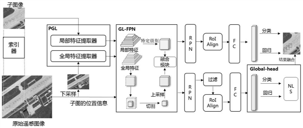
[0073] Specific implementation mode 1. Combination Figure 1 to Figure 3 As shown, the present invention provides a method for target detection of large-scale aerial remote sensing images, which is characterized in that it includes,

[0074] The original remote sensing image set is composed of original remote sensing images, and each original remote sensing image is configured with an original image name;

[0075] Divide each original remote sensing image into subimages of a preset size according to a predetermined overlapping ratio, and configure a subimage name for each subimage, and the subimage name includes the original image name, subimage serial number, and subimage on the original remote sensing image The starting position information of ;

[0076] Obtaining the corresponding current original remote sensing image by retrieving the original remote sensing image set according to the sub-image name of the current sub-image to be detected;

[0077] Use a local feature ex...

specific Embodiment

[0134] mAP is used as the evaluation index.

[0135] In order to verify the performance of the present invention on large-scale aerial images, the DOTA [17] dataset is used, which is a large-scale dataset containing aerial images for object detection, which contains many large-scale images, mainly from Google Earth , satellite and aerial imagery. There are three versions of DOTA dataset: DOTA-v1.0, DOTA-v1.5 and DOTA-v2.0. Use the label box of HBB.

[0136] DOTA-v1.0 has a total of 2806 images ranging in size from 800 to 4000 pixels, including 15 categories and 188282 objects. DOTA-v1.5 annotates many small objects that are difficult to detect, and also adds a new category called "Container Cranes". DOTA-v2.0 version contains 402089 instances. DOTA-v2.0 is quite different from previous versions, with a total of 18 categories ("Airport" and "Helipad" were added), 11,286 images, and 1,793,658 objects. The results in the experiments are the test set accuracy.

[0137] For c...


PUM


Abstract

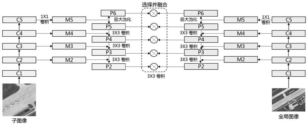
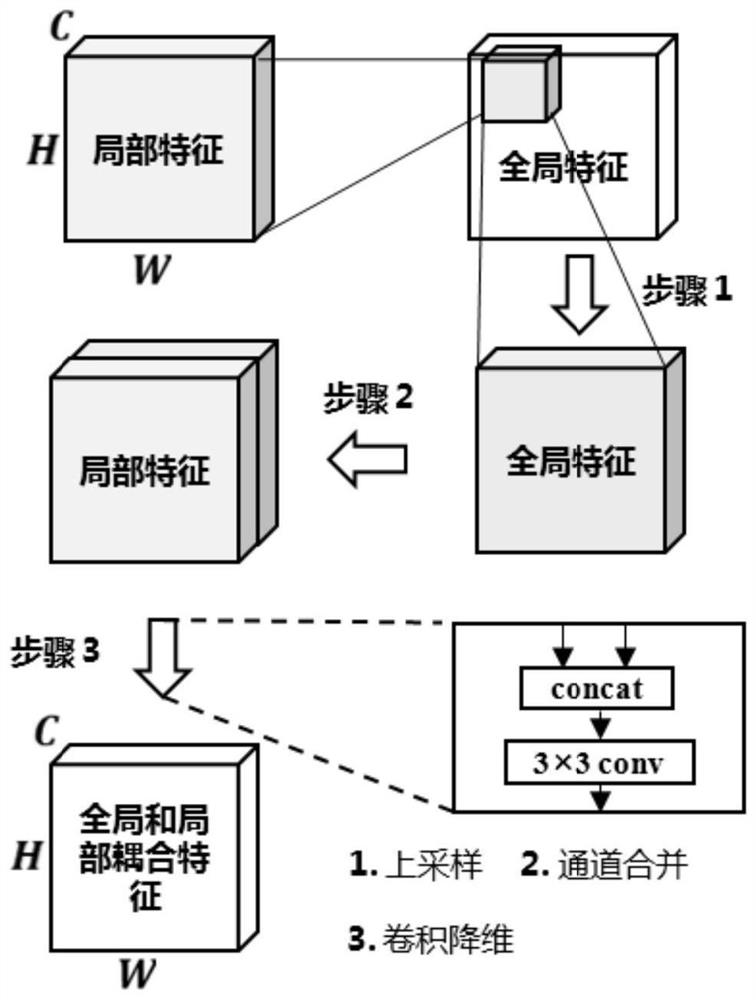
The invention discloses a target detection method for a large-size aerial remote sensing image, and belongs to the technical field of target detection. The invention aims at solving the problem that contextual information of a large-size aerial remote sensing image is lost due to image segmentation. The method comprises the following steps: determining an original image name; configuring a subgraph name for a subgraph; retrieving in an original remote sensing image set according to the subgraph name to obtain a corresponding current original remote sensing image; performing feature extraction on a current to-be-detected sub-graph by adopting a local feature extractor to obtain a group of multi-scale sub-graph feature graphs; performing down-sampling on the current original remote sensing image, and performing feature extraction by using a global feature extractor to obtain a group of multi-scale original image feature graphs; adopting a feature pyramid network of a global and local coupling mechanism to obtain a fused feature graph; respectively obtaining a target prediction result and a filtered global prediction result; re-fusing the fusion target prediction result and the filtered global prediction result to obtain a detection target. The invention is used for target detection.

Description

technical field [0001] The invention relates to a target detection method for large-scale aerial remote sensing images, and belongs to the technical field of target detection. Background technique [0002] With the development of image sensors and aviation technology, the resolution of aerial remote sensing optical images has gradually increased, and the amount of data contained in images has also increased significantly. Object detection is one of the commonly used techniques in computer vision, which is used to infer the position and category of each target object in an image. In the application field of high-resolution aerial remote sensing images, object detection technology can play an important role in building recognition, natural disaster management, change detection, traffic planning, agricultural survey, military, etc. [0003] Compared with natural images in computer vision, aerial remote sensing images have larger resolution and size. The large-scale images pro...

Claims


Application Information

Patent Timeline
IPC IPC(8): G06V20/10G06V10/25G06V10/80G06K9/62G06N3/04
CPCG06N3/045G06F18/253
Inventor 王超杰陈曦李治洪刘敏郑来文方涛李庆利刘小平
Owner EAST CHINA NORMAL UNIV
Learn More