Coordinate joint surveying and mapping calibration method based on total station and RTK

A calibration method and technology of total station, applied in surveying and mapping and navigation, satellite radio beacon positioning system, instruments, etc., can solve the problems of high positioning accuracy, signal occlusion, insufficient stability and reliability, etc., and achieve low laying cost and low cost , Stable and reliable high-precision positioning effect

Pending Publication Date: 2022-01-18
上智联检测技术(上海)有限公司
View PDF0 Cites 0 Cited by
  • Summary
  • Abstract
  • Description
  • Claims
  • Application Information

AI Technical Summary

Problems solved by technology

[0002] The global satellite navigation system represented by GPS and Beidou has been widely used in various fields, especially in the field of automatic driving and vehicle-road coordination. In open outdoor scenes, the GPS-based integrated navigation system can provide high-level automatic driving requirements. However, due to the problem of signal occlusion indoors, GPS cannot provide reliable positioning information under indoor conditions. In the construction of the first phase of the project, the underground garage adopts UWB indoor positioning, which is currently the mainstream indoor positioning. Positioning technology, UWB has strong penetrating ability, good anti-multipath effect, high security, low system complexity, and high positioning accuracy, but at the same time, there are many shortcomings. For example, the laying cost of UWB communication base stations is high, and it cannot be widely used in a wide range. , it is difficult to promote in the short term
[0003] At present, the methods used for indoor positioning basically include UWB or lidar SLAM. In academic research, there is indoor positioning based on camera vision. At present, the global satellite navigation system represented by GPS and Beidou is only suitable for indoor open spaces, and indoor UWB communication The cost of base station laying is high, it cannot be widely used in a wide range, and it is difficult to promote in the short term. Lidar SLAM has high environmental requirements and is not stable and reliable. At present, there is no detailed and complete method based on the joint calibration of two-dimensional code coordinates based on total stations and RTK

Method used


Image

  • Coordinate joint surveying and mapping calibration method based on total station and RTK
  • Coordinate joint surveying and mapping calibration method based on total station and RTK

Examples


Embodiment

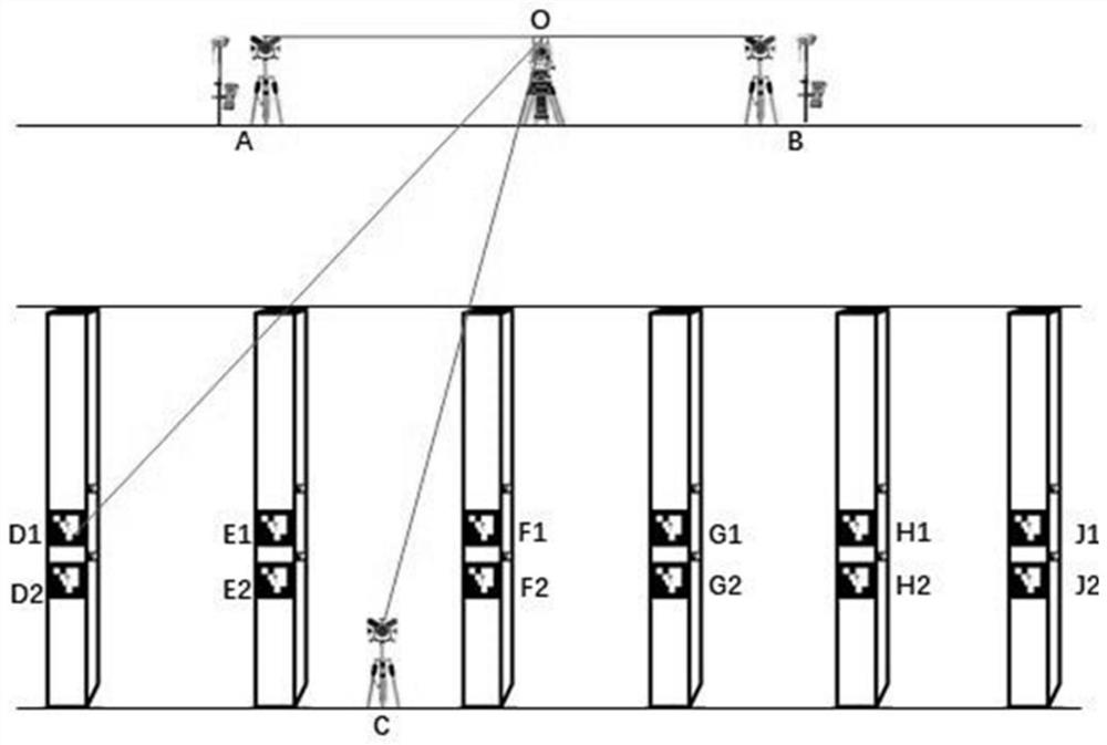
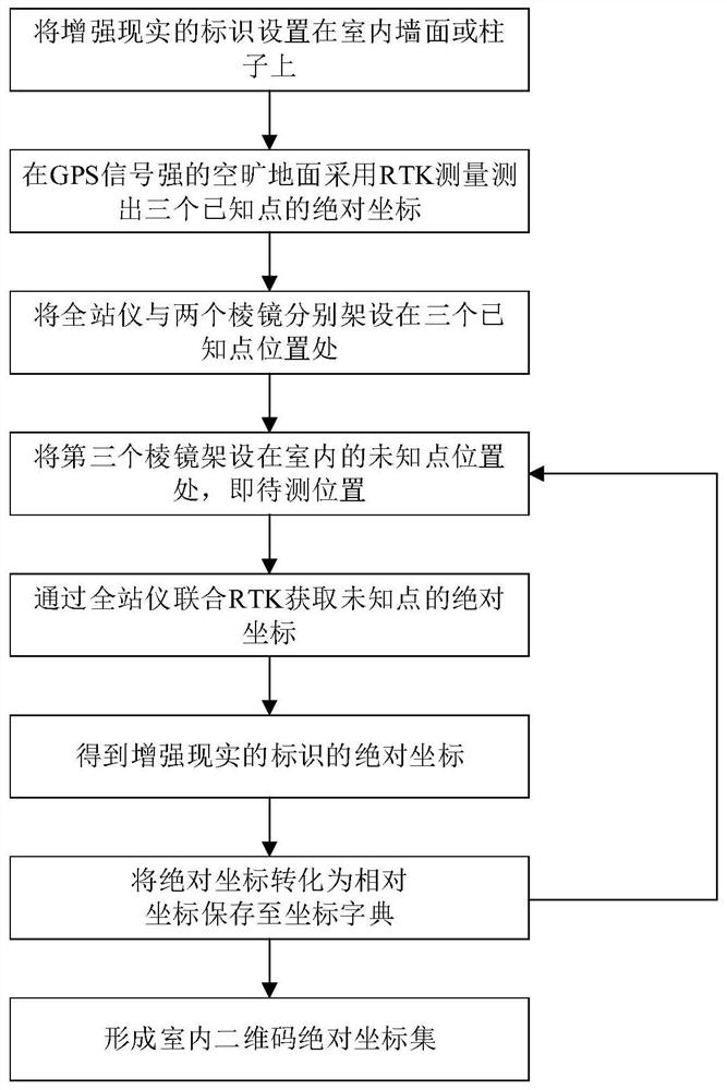
[0035] The present invention provides a system for realizing the coordinate surveying and mapping calibration method based on total station and RTK, including RTK, total station, augmented reality logo and three prisms arranged on walls or columns, augmented reality logo It is a flat structure with features, including ArUco code and AirTag, etc. The augmented reality logo is composed of two boards. Two-dimensional code, the side length of the two-dimensional code is 45cm, and the coordinates of the center of the two-dimensional code are used as the point to be measured during calibration.

[0036] When arranging augmented reality signs, the angle between the inner side of the two boards and the wall is 45° is the best. In a specially arranged venue, if all the augmented reality signs are attached to the same height and the same wall, erect 2 panels. -4 QR codes are the best.

[0037] Such as figure 1 As shown, there are two augmented reality logos on the 6 pillars, and there...


PUM


Abstract

The invention relates to a coordinate joint surveying and mapping calibration method based on a total station and RTK. The method comprises the steps: S1, arranging an augmented reality identifier on an indoor wall surface or a column; s2, measuring absolute coordinates of the three known points by adopting RTK measurement; s3, erecting the total station and the two prisms at the three known points respectively; s4, erecting a third prism at an indoor unknown point; s5, obtaining the absolute coordinates of the unknown point through the total station in combination with RTK; s6, marking the absolute coordinate of the augmented reality identifier according to the absolute coordinate of the unknown point and the vector relationship between the unknown point and the augmented reality identifier; s7, converting the absolute coordinates, generating indoor relative coordinates, and storing the indoor relative coordinates in a coordinate dictionary; and S8, transforming unknown points, repeating the steps S4-S6, forming an indoor two-dimensional code relative coordinate set, and identifying the indoor two-dimensional code to realize indoor high-precision positioning. Compared with the prior art, the method has the advantages of solving the problem of indoor high-precision positioning in automatic driving, and being low in cost, stable, reliable and the like.

Description

technical field [0001] The invention relates to the technical field of coordinate calibration, in particular to a coordinate joint surveying and mapping calibration method based on a total station and RTK. Background technique [0002] The global satellite navigation system represented by GPS and Beidou has been widely used in various fields, especially in the field of automatic driving and vehicle-road coordination. In open outdoor scenes, the GPS-based integrated navigation system can provide high-level automatic driving requirements. However, due to the problem of signal occlusion indoors, GPS cannot provide reliable positioning information under indoor conditions. In the construction of the first phase of the project, the underground garage adopts UWB indoor positioning, which is currently the mainstream indoor positioning. Positioning technology, UWB has strong penetrating ability, good anti-multipath effect, high security, low system complexity, and high positioning ac...

Claims


Application Information

Patent Timeline
Patent Type & Authority Applications(China)
IPC IPC(8): G01C21/20G01C25/00G01S19/44G01S19/41G01C15/00
CPCG01C21/206G01C25/005G01S19/44G01S19/41G01C15/00
Inventor 姜乐刘续博林新雨
Owner 上智联检测技术(上海)有限公司
Why Eureka
Try Eureka