
Method for correcting spectral position of infrared hyperspectral data of meteorological satellite

A technology of meteorological satellites and correction methods, applied in the field of hyperspectral data, can solve problems such as huge computational load, and achieve the effect of meeting the needs of real-time applications

Active Publication Date: 2022-01-14
郭强
View PDF4 Cites 0 Cited by
  • Summary
  • Abstract
  • Description
  • Claims
  • Application Information

AI Technical Summary

Problems solved by technology

For hyperspectral detectors of polar-orbiting meteorological satellites with 4 or 9 detectors, the calculation amount required for correction processing is acceptable; but for similar remote sensors like GIIRS working in geostationary orbit, due to its The number of probes will reach 10 2 -10 3 magnitude, such a huge amount of computation is unacceptable

Method used


Image

  • Method for correcting spectral position of infrared hyperspectral data of meteorological satellite
  • Method for correcting spectral position of infrared hyperspectral data of meteorological satellite
  • Method for correcting spectral position of infrared hyperspectral data of meteorological satellite

Examples


Embodiment Construction

[0033] In order to facilitate the understanding of the present invention, the present invention will be described in more detail below in conjunction with the accompanying drawings and specific embodiments. Unless otherwise defined, all technical and scientific terms used in this specification have the same meaning as commonly understood by one of ordinary skill in the technical field of the invention. The terms used in the description of the present invention in this specification are only for the purpose of describing specific embodiments, and are not used to limit the present invention. The term "and / or" used in this specification includes any and all combinations of one or more of the associated listed items.

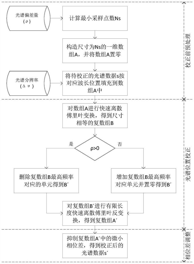
[0034]The present invention starts from the physical principle of spectral resampling, utilizes the frequency-domain sampling and time-domain restoration characteristics of discrete Fourier transform, and realizes spectral deviation correction by adjusting the numbe...


PUM


Abstract

The invention discloses a method for correcting the spectral position of infrared hyperspectral data of a meteorological satellite, which comprises the following steps of: pre-correction treatment: constructing a new spectral data sequence A with the length of Ns for correction according to an input to-be-corrected spectral deviation value; spectral position correction: for an array A, adopting a newly designed fast discrete Fourier transform (FDFT) method, and utilizing a pair of FDFTs to obtain a composite array A' after spectral position correction; and phase difference adjustment: correcting a tiny phase change caused by spectral position correction for A'. By adopting the technical scheme of the invention, the position precision of the corrected long-wave and medium-wave infrared spectra is superior to 10ppm, and compared with a reference instrument or a numerical weather forecast field result, the position precision is not absolute position precision and is accepted by international authoritative institutions, the numerical weather forecast application is met, and the processing time efficiency meets the real-time application requirement.

Description

technical field [0001] The invention relates to the field of hyperspectral data, in particular to a method for correcting spectral positions of meteorological satellite infrared hyperspectral data. Background technique [0002] Space-borne infrared atmospheric remote sensing with high spectral resolution provides unprecedented observation methods for modern numerical weather prediction, atmospheric environment monitoring, and climate change research. The interferometric atmospheric vertical sounder based on Fourier transform (or Michelson interferometric) spectroscopy technology is the main development direction of the current international three-dimensional vertical atmospheric detection. At present, there are 6 Michelson interferometers in the infrared band in orbit around the world, 2 in the United States and 2 in Europe, both mounted on polar-orbiting weather satellites; 2 in China, and 1 in polar-orbiting and geostationary weather satellites. Among them, the GIIRS (Geo...

Claims


Application Information

Patent Timeline
Patent Type & Authority Applications(China)
IPC IPC(8): G01J3/02G01J3/45
CPCG01J3/0297G01J3/0275G01J3/45Y02A90/10
Inventor 郭强王新
Owner 郭强
Learn More