
Earthwork calculation method and system based on unmanned aerial vehicle oblique photography and storage medium

A technology of oblique photography and calculation method, applied in the field of unmanned aerial vehicle surveying and mapping, which can solve the problems of deviation and inconsistency of earth and rock volume, and achieve the effect of accurate earth and rock volume.

Pending Publication Date: 2022-01-14
中煤浙江测绘地理信息有限公司
View PDF0 Cites 3 Cited by
  • Summary
  • Abstract
  • Description
  • Claims
  • Application Information

AI Technical Summary

Problems solved by technology

[0004] In view of the related technologies mentioned above, the inventor believes that when the vegetation area is large, there may be a large difference between the terrain inside the area and its surroundings. If the vegetation is directly deleted and then repaired through the surrounding ground, it is likely to be inconsistent with the actual ground conditions, resulting in There is a large deviation in the calculated earth and stone volume

Method used


Image

  • Earthwork calculation method and system based on unmanned aerial vehicle oblique photography and storage medium
  • Earthwork calculation method and system based on unmanned aerial vehicle oblique photography and storage medium
  • Earthwork calculation method and system based on unmanned aerial vehicle oblique photography and storage medium

Examples


Embodiment Construction

[0056] The following is attached Figure 1 to Figure 4 The application is described in further detail.

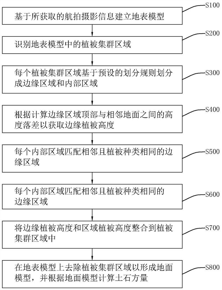
[0057] Before road construction, platform construction and other projects officially start, it is necessary to survey and map the construction site, and establish a three-dimensional map model based on the survey and mapping data, so as to evaluate whether the amount of earth and stone to be excavated after construction is reasonable. When the evaluation results exceed expectations, timely Change the construction plan. However, the vegetation in the construction site will affect the surveying and mapping work, and the vegetation should be cleared before surveying and mapping. Once the construction plan changes, the work of clearing the vegetation will be in vain. Therefore, it is necessary to reduce the impact of vegetation on the map model without clearing the vegetation. To this end, the embodiment of the present application discloses an earthwork calculation method bas...


PUM


Abstract

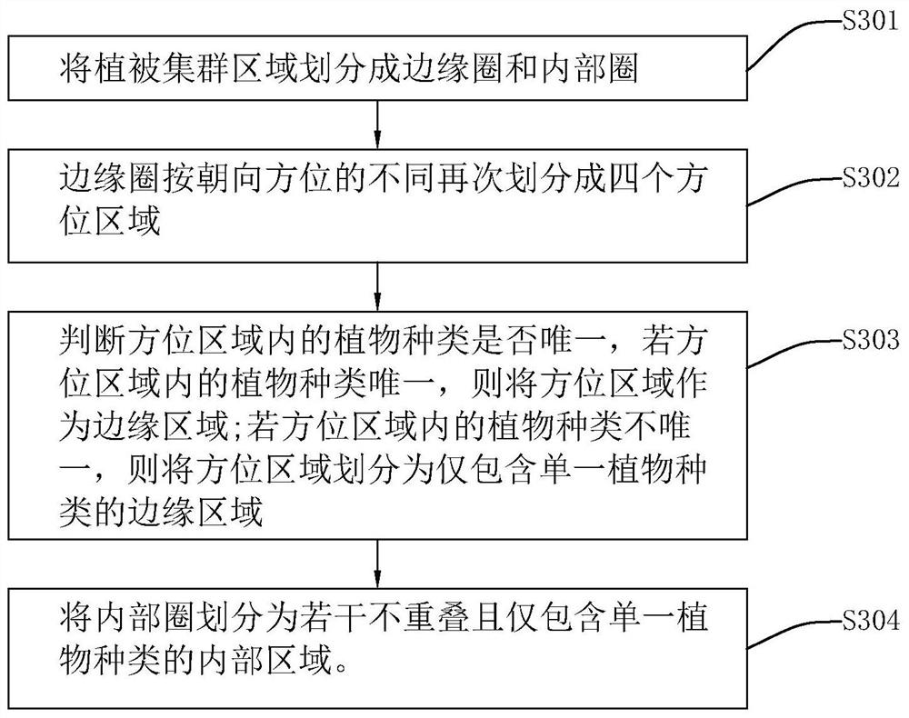
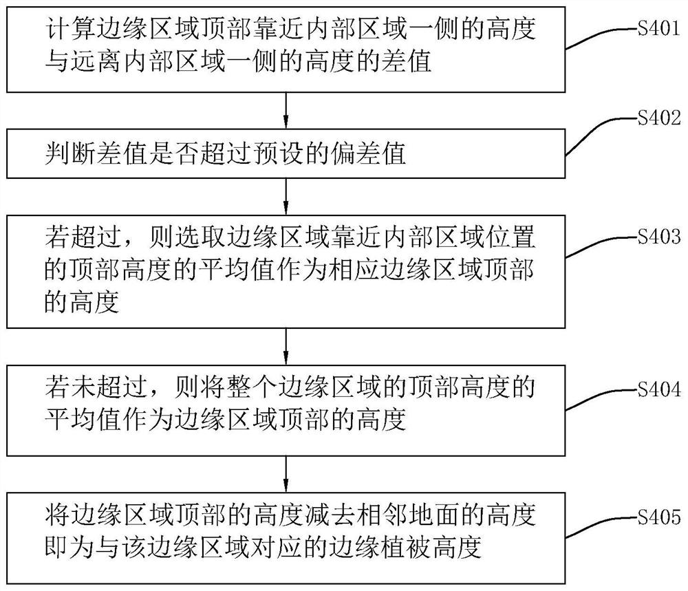
The invention discloses an earthwork calculation method and system based on unmanned aerial vehicle oblique photography and a storage medium, and relates to the technical field of unmanned aerial vehicle surveying and mapping, and the method comprises the following steps: building a ground surface model based on obtained aerial photography information; identifying a vegetation cluster area in the earth surface model; dividing each vegetation cluster area into an edge area and an internal area based on a preset division rule, and obtaining an edge vegetation height; matching each internal area with an adjacent edge area with the same vegetation type; executing different preset methods to obtain the regional vegetation height of the corresponding internal region; removing a vegetation cluster area on the ground surface model to form a ground surface model; and calculating the earthwork volume according to the ground model. The vegetation height of the internal area can be calculated according to the rule by calculating the vegetation height of the edge area, the vegetation interference of the vegetation cluster area is removed by the obtained vegetation height, the real landform can be restored more completely, and the finally calculated earth-rock volume is more accurate.

Description

technical field [0001] The present application relates to the field of UAV surveying and mapping, in particular to an earthwork calculation method, system and storage medium based on UAV oblique photography. Background technique [0002] In the traditional earthwork construction process, the construction progress of a certain area is controlled by the elevation, and the total earthwork construction progress is reflected by the total number of unearthed vehicles. Due to the limitations of the measurement methods, rapid multiple measurements cannot be performed. UAV oblique photogrammetry technology is a new technology developed in recent years. It collects image data with elevation and position information through UAV, and reconstructs the real scene by computer in the later stage, which can truly reflect the appearance, position and height of ground objects. At the same time, it can output results such as orthophoto maps, digital elevation models and point clouds. [0003] ...

Claims


Application Information

Patent Timeline
Patent Type & Authority Applications(China)
IPC IPC(8): G01C11/00G01C11/36B64C39/02
CPCG01C11/00B64C39/028B64U2101/30
Inventor 段月辉倪荣雷贺飞越包赛赛韩月汪菲胡东度毛吉伟王建国李君吴相辉胡奥琪贾魁
Owner 中煤浙江测绘地理信息有限公司
Learn More