
Landslide risk evaluation method and system based on slope features, and storage medium

A landslide risk and evaluation method technology, applied in resources, instruments, climate change adaptation, etc., can solve problems such as poor operability and reliability, low accuracy rate, narrow application range, etc., to ensure reliability, improve reliability, The effect of improving computational efficiency

Pending Publication Date: 2021-12-10
WUHAN CENT CHINA GEOLOGICAL SURVEY CENT SOUTH CHINA INNOVATION CENT FOR GEOSCIENCES
View PDF0 Cites 1 Cited by
  • Summary
  • Abstract
  • Description
  • Claims
  • Application Information

AI Technical Summary

Problems solved by technology

However, limited by the spatial differences of parameters in the historical process of rock and soil formation and the efficiency of regional landslide probability calculations, the above-mentioned method fails to take into account the slope characteristics reflected by the spatial differences of parameters, and cannot be very accurate. Well integrated into the risk assessment of regional landslide disasters, the accuracy of prediction and evaluation is low, and the efficiency of calculating the probability of regional landslides is also low. It can only be applied to the risk assessment of some soil landslides. and less reliable

Method used


Image

  • Landslide risk evaluation method and system based on slope features, and storage medium
  • Landslide risk evaluation method and system based on slope features, and storage medium
  • Landslide risk evaluation method and system based on slope features, and storage medium

Examples


Embodiment 1

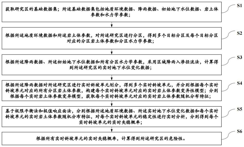
[0030] Embodiment one, as figure 1 As shown, a landslide risk assessment method based on slope characteristics includes the following steps:

[0031] S1: Obtain the basic data set of the research area; the basic data set includes geological environment data, rainfall data, initial groundwater level data, rock and soil mass parameters and hydraulic parameters;

[0032] S2: According to the geological environment data and the rock and soil mass parameters, divide the research area to obtain a plurality of target zones and zone rock and soil parameters and zone hydraulic parameters corresponding to each target zone;

[0033] S3: According to the rainfall data, the initial groundwater level data and hydraulic parameters of all zones, the real-time groundwater level change data of the research area is calculated by using the regional rainfall infiltration runoff method;

[0034] S4: Divide the study area into real-time slope units according to the rainfall data to obtain a plurali...

Embodiment 2

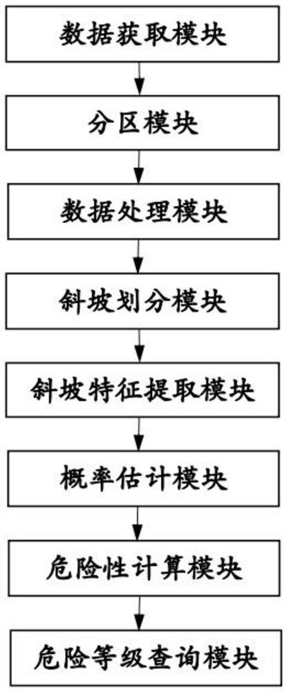
[0100] Embodiment two, such as figure 2 As shown, a landslide risk assessment system based on slope features is applied to the landslide risk assessment method based on slope features in Embodiment 1, including a data acquisition module, a partition module, a data processing module, a slope division module, and a slope feature extraction module , probability estimation module and risk calculation module;

[0101] The data acquisition module is used to obtain the basic data set of the research area; the basic data set includes geological environment data, rainfall data, initial groundwater level data, rock and soil mass parameters and hydraulic parameters;

[0102] The partitioning module is used to partition the research area according to the geological environment data and the rock and soil mass parameters, and obtain multiple target partitions and the partition rock and soil mass parameters and partition hydraulics corresponding to each target partition parameter;

[0103...

Embodiment 3

[0150] Embodiment 3, based on Embodiment 1 and Embodiment 2, this embodiment also discloses a landslide risk assessment system based on slope characteristics, including a processor, a memory, and stored in the memory and operable on the processor. A computer program on the computer program, when the computer program runs, it realizes as figure 1 The specific steps from S1 to S6 are shown.

[0151] Through the computer program stored in the memory and run on the processor, the landslide disaster risk assessment is realized, and the instability probability is calculated based on the random distribution characteristics of the real-time rock and soil parameters corresponding to each real-time slope unit, which can take into account Parameter space differences, while using the ideas of partition and slope unit division, effectively improve the accuracy and efficiency of evaluation, broaden the scope of application, and have strong operability and reliability.

[0152] This embodim...


PUM


Abstract

The invention relates to a landslide risk evaluation method and system based on slope features, and a storage medium. The method comprises: obtaining a basic data set of a research area; partitioning the research area to obtain a plurality of target partitions and partition rock-soil body parameters and partition hydraulic parameters of each target partition; obtaining real-time underground water level change data through calculation by adopting a regional rainfall infiltration runoff method; performing real-time slope unit division on the research area, and respectively constructing a real-time rock-soil body parameter variability model corresponding to each real-time slope unit; obtaining real-time rock-soil body parameter random distribution characteristics of each real-time slope unit; based on a limit equilibrium method and an extreme value response surface method, performing real-time analysis on the stability of each real-time slope unit to obtain a real-time instability probability of each real-time slope unit; and calculating the danger of the research area according to all the real-time instability probabilities. Based on slope features, parameter space difference can be considered, accuracy and efficiency are improved, and operability and reliability are high.

Description

technical field [0001] The invention relates to the field of landslide risk assessment, in particular to a landslide risk assessment method, system and storage medium based on slope characteristics. Background technique [0002] In recent years, the country has actively carried out the prevention and control of geological disasters and achieved gratifying results. However, due to the existence of various uncertain factors, it is difficult to completely avoid the occurrence of landslides. As long as there is the possibility of landslides, there will inevitably be landslide risks. Among them, landslide disaster risk assessment is the basis of landslide risk research, and it is also an important means to realize landslide disaster prediction and forecast, and then formulate prevention and control plans. [0003] With the development of computers, the physical-mechanical model based on the mechanical mechanism of individual landslides has been gradually applied to the risk asse...

Claims


Application Information

Patent Timeline
Patent Type & Authority Applications(China)
IPC IPC(8): G06Q10/06G06Q50/26G06F30/28G06F111/08G06F113/08G06F119/14
CPCG06Q10/0635G06Q50/265G06F30/28G06F2111/08G06F2113/08G06F2119/14Y02A50/00
Inventor 刘磊谭建民连志鹏徐勇王宁涛周丹坤
Owner WUHAN CENT CHINA GEOLOGICAL SURVEY CENT SOUTH CHINA INNOVATION CENT FOR GEOSCIENCES
Learn More