Remote sensing and monitoring global target space coverage optimization method

A coverage optimization and global target technology, which is applied in the field of long-distance perception and coverage of three-dimensional space on the earth's surface by three-dimensional directional sensors. The effect of good optimization speed and convergence

Active Publication Date: 2021-09-28
10TH RES INST OF CETC
View PDF10 Cites 0 Cited by
  • Summary
  • Abstract
  • Description
  • Claims
  • Application Information

AI Technical Summary

Problems solved by technology

[0010] The purpose of the present invention is to solve the defect that the existing perception model cannot effectively describe the real perception ability of the wireless multimedia sensor and the optimization problem of the three-dimensional directional sensor for the long-distance perception coverage of the three-dimensional space on the earth's surface and the deficiency of the existing

Method used


Image

  • Remote sensing and monitoring global target space coverage optimization method
  • Remote sensing and monitoring global target space coverage optimization method
  • Remote sensing and monitoring global target space coverage optimization method

Examples


Embodiment Construction

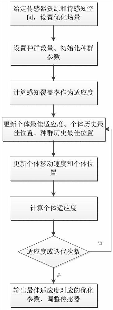
[0019] refer to figure 1 , figure 2. According to the present invention, first screen out the sensors that can perceive the space to be sensed, and combine the azimuth and elevation angles of these sensor perception directions as individuals and as optimization parameters; given the sensor resources and the space to be sensed, set the perception coverage optimization scene, The number of populations, initializing the population and the parameters required by the particle swarm algorithm; forming a number of directional three-dimensional sensors with fixed positions to form a three-dimensional space directional sensor network that senses and covers the three-dimensional space to be sensed above the earth's surface, with any shape and a certain thickness; Adjust the azimuth and elevation angles of the sensing direction of each sensor center in the directed sensor network, and establish a set coverage model that can effectively track and identify moving targets in the monitorin...


PUM


Abstract

According to the remote sensing and monitoring global target space coverage optimization method disclosed by the invention, aerial targets in a certain height range can be effectively sensed. The method can be realized through the following scheme: firstly, screening out sensors capable of sensing a to-be-sensed target space, forming a three-dimensional space directed sensor network of sensing coverage, and establishing a set coverage model; counting the coverage range of discrete points of the three-dimensional to-be-sensed space, calculating the sensing coverage rate, and iteratively optimizing the fitness function. The directional sensors are adjusted to solve the sensing coverage rate of the whole directional sensor network to the space to be sensed, the pitch angle and the azimuth angle of each sensor are iteratively optimized by using a random search algorithm, and the specified three-dimensional aerial target on the earth surface is sensed and covered until the coverage rate requirement or the iteration frequency requirement is met. Optimizing parameters are output through the intelligent optimization algorithm to adjust the azimuth angle and the pitch angle of the sensor, and global optimal space coverage is obtained by optimizing the main sensing direction.

Description

technical field [0001] The invention relates to the field of sensor network coverage perception widely used in the fields of environment monitoring and traffic monitoring, in particular to an optimization method for three-dimensional directional sensors on the three-dimensional long-distance perception coverage of the earth's surface. [0002] technical background [0003] Today, the ternary objects of "human, machine and object" widely exist in cyberspace, among which, wireless multimedia sensors realize the compression of multimedia content and data transmission with low traffic, and the generated data becomes one of the objects in cyberspace. It is an important component, and provides a theoretical basis and strong guarantee for the practical application of wireless multimedia sensor networks. Coverage, as an important index to measure the monitoring capability of sensor networks, is directly related to the service quality of the network. The effective space coverage rate ...

Claims


Application Information

Patent Timeline
IPC IPC(8): H04W4/38H04W16/18H04W16/22
CPCH04W4/38H04W16/18H04W16/22Y02D30/70
Inventor 李奇真龙慧敏张希会张萌刘勇董海
Owner 10TH RES INST OF CETC
Why Eureka
Try Eureka