
Pixel scale winter wheat per unit yield remote sensing estimation method based on multi-scenario simulation

A winter wheat and multi-scenario technology, applied in the field of remote sensing estimation, can solve problems such as uncertainty differences in different regions and wide-scale applicability problems, and achieve the effects of reducing manpower and time costs, improving feasibility, and reducing dependence

Active Publication Date: 2021-09-07
AEROSPACE INFORMATION RES INST CAS
View PDF4 Cites 6 Cited by
  • Summary
  • Abstract
  • Description
  • Claims
  • Application Information

AI Technical Summary

Problems solved by technology

Existing models mainly focus on the research of remote sensing data and crop growth model assimilation algorithms, but limited by the complicated localization process of crop growth models, the method of remote sensing and crop growth model assimilation has encountered a wide range of applicability problems. There is a large difference in uncertainty

Method used


Image

  • Pixel scale winter wheat per unit yield remote sensing estimation method based on multi-scenario simulation
  • Pixel scale winter wheat per unit yield remote sensing estimation method based on multi-scenario simulation
  • Pixel scale winter wheat per unit yield remote sensing estimation method based on multi-scenario simulation

Examples


Embodiment Construction

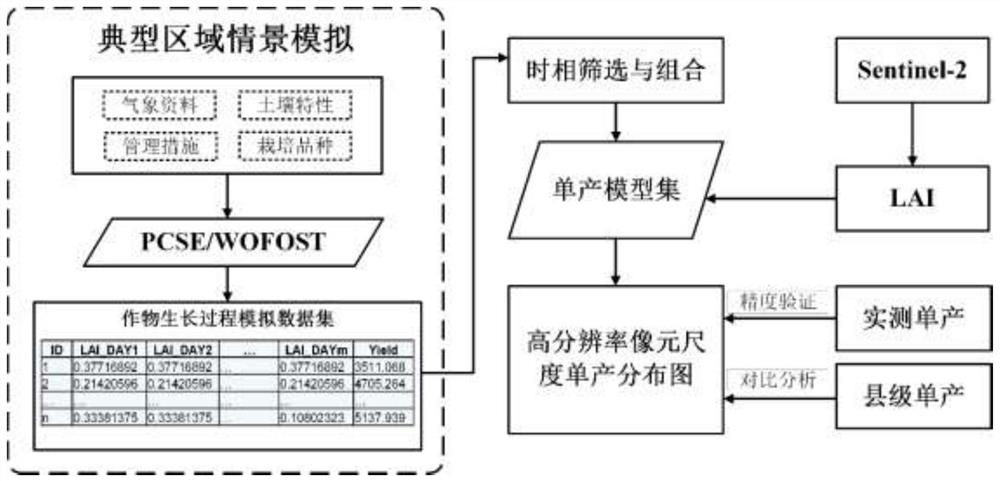
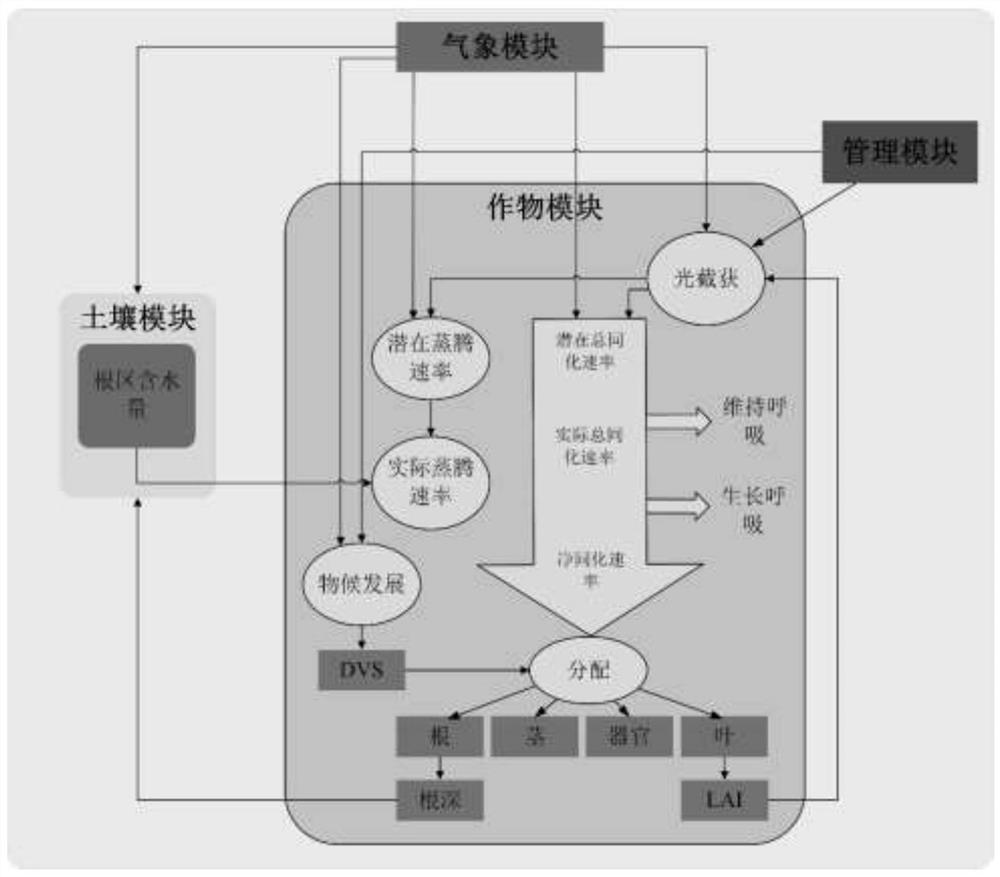
[0056] Based on the formation mechanism of crop yield, firstly, by collecting various factors that have occurred or may occur in the area that affect the yield of winter wheat (meteorology, soil, variety, management), use the crop growth model to perform dynamic simulation of the formation process of winter wheat yield, and obtain complete samples dataset to address the lack of ground-based observation data. Secondly, based on the complete sample data set obtained by simulation, the key index factors that can be monitored and obtained by remote sensing at different growth stages of winter wheat are screened and determined, and the evolution law of key index factors that affect the yield formation during the growth process of winter wheat is explored and analyzed. On this basis, the research realizes the quantitative mathematical description of the key index factors of each growth stage on the formation of winter wheat yield, and finally builds a set of yield estimation models b...


PUM


Abstract

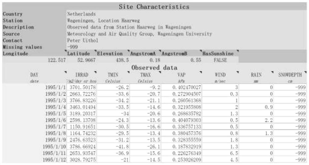
The invention discloses a pixel scale winter wheat per unit yield remote sensing estimation method based on multi-scenario simulation. The method comprises the steps of forming a process simulation data set in a multi-scenario region winter wheat per unit yield based on a crop growth model, constructing a region winter wheat per unit yield model set, and performing region winter wheat per unit yield estimation demonstration research based on high-resolution remote sensing data; and verifying and evaluating a high-resolution winter wheat per unit yield distribution estimation result through field actual measurement data and county-level statistical data. By utilizing the simulation result of the crop growth model, per unit yield regression modeling can be effectively carried out, and the dependence of the model on ground samples is reduced. A set of scene parameter group is formed by collecting years of historical meteorological data, soil type parameters, crop variety parameters and farmland management measures of winter wheat planting areas in the Hebei province, the scene parameter group is input into the WOFOST model to obtain the growth process of the winter wheat under different scenes, no ground sample is used for correction, the manpower and time cost is reduced. And the feasibility of the model is improved.

Description

technical field [0001] The invention relates to the technical field of remote sensing estimation. Specifically, it is a pixel-scale winter wheat yield remote sensing estimation method based on multi-scenario simulation. Background technique [0002] Since the beginning of the 21st century, with the rapid development of precision agriculture, the demand for crop yield estimation has not only been satisfied with regional calculations at the national, provincial and municipal scales, but has gradually focused on the crop yield level at the plot scale. The statistical regression model constructed based on ground yield samples and remote sensing spectral information has a high yield estimation accuracy, and the yield prediction accuracy and the ground sample R 2 It can reach more than 0.9 (Hunt et al., 2019), but this method requires a large number of samples, and in practical applications, there are defects such as difficult sample collection and poor regional extrapolation. W...

Claims


Application Information

Patent Timeline
Patent Type & Authority Applications(China)
IPC IPC(8): G06F30/27G06Q10/06G06K9/62G06F17/18G06Q50/02
CPCG06F30/27G06Q10/06393G06F17/18G06Q50/02G06F18/214Y02A90/10
Inventor 杜鑫李强子朱炯王红岩张源
Owner AEROSPACE INFORMATION RES INST CAS
Learn More