
Vegetation diversity detection method based on consumer-level unmanned aerial vehicle

A detection method and unmanned aerial vehicle technology, applied in the interpretation of photos, computer components, instruments, etc., can solve the problems that vegetation monitoring cannot be applied, difficult vegetation diversity automatic calculation, etc., to reduce subjectivity and cumbersomeness, The effect of increasing the amount of survey data and widening the scope of application

Pending Publication Date: 2021-07-30
DATONG COAL MINE GRP +1
View PDF6 Cites 4 Cited by
  • Summary
  • Abstract
  • Description
  • Claims
  • Application Information

AI Technical Summary

Problems solved by technology

However, most of these patents rely on professional UAVs equipped with lidar, which have high requirements for equipment and operating technology, or are difficult to realize automatic calculation of vegetation diversity, and cannot be applied to vegetation monitoring implemented by grassroots units

Method used


Image

  • Vegetation diversity detection method based on consumer-level unmanned aerial vehicle
  • Vegetation diversity detection method based on consumer-level unmanned aerial vehicle
  • Vegetation diversity detection method based on consumer-level unmanned aerial vehicle

Examples


Embodiment 1

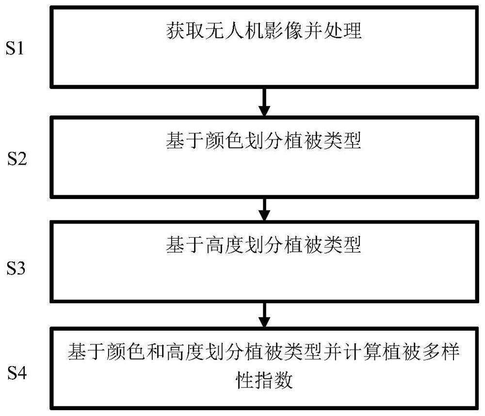
[0056] The specific steps of a vegetation diversity detection method based on consumer-grade unmanned aerial vehicles include:

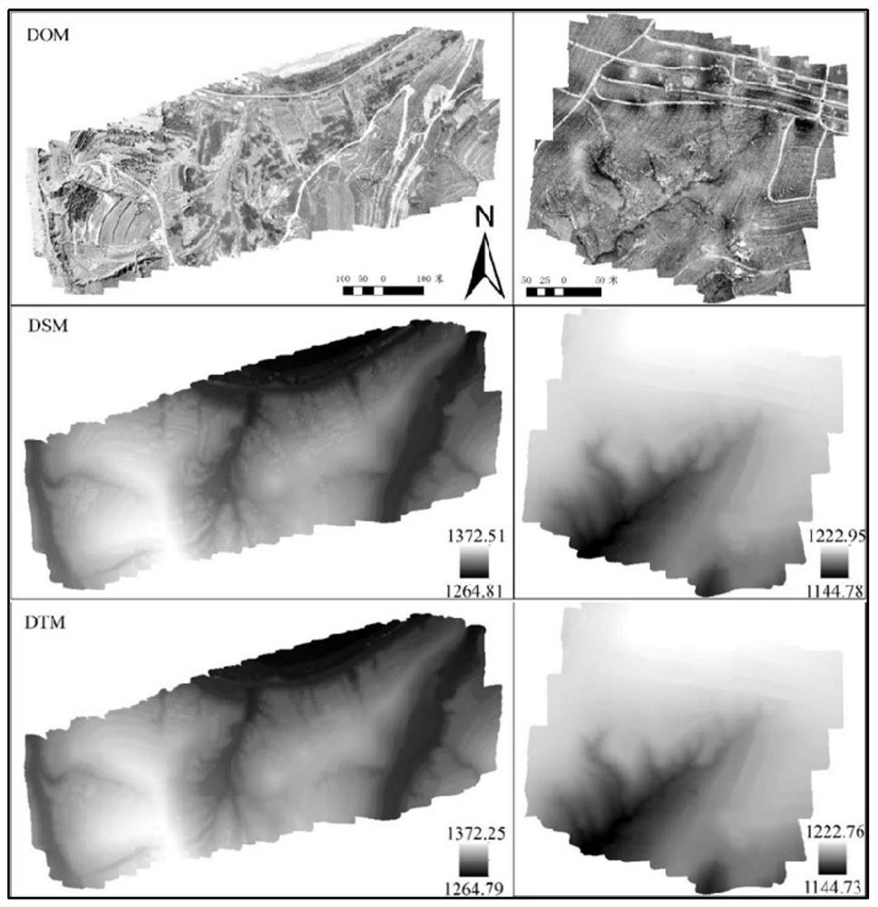
[0057] S1. Use consumer-grade drones to acquire digital orthophoto images DOM, digital ground surface model images DSM, and digital terrain model images DTM)

[0058] In this example, two areas in the southern suburbs of Datong City, Shanxi Province are selected as drone flight areas. The collection time is between 9:00 am and 12:00 am on August 22 and 23, 2019. The drone used in this study is the DJI Mavic 2 Professional Edition drone device, and the aerial camera equipped is L1D-20c Hasselblad camera. On the day of UAV data collection, the field of view was good and the wind speed was low. The flying height of the UAV is 100 meters, the flying height is 100 meters, the gimbal angle is -90°, the side overlap rate is 65%, the heading overlap rate is 70%, and the safe return height is 100 meters. Before the drone took off, 10 phase control points w...


PUM


Abstract

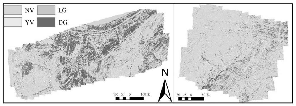
The invention discloses a vegetation diversity detection method based on a consumer-level unmanned aerial vehicle, and is applicable to the field of land cover detection. A digital orthoimage, a digital ground surface model image and a digital terrain model image of a research area are obtained through the consumer-level unmanned aerial vehicle, a vegetation greenness index distribution diagram of the area is obtained through calculation of the digital orthoimage, and vegetation types are divided according to colors; the vegetation height is calculated by using the digital surface model image and the digital terrain model image, the vegetation type is divided according to the height, finally the vegetation type is divided according to the vegetation color and height, the research area is divided into a plurality of units, and the vegetation diversity distribution condition in the region is calculated according to the vegetation type and the coverage of each unit, so that vegetation diversity detection is achieved. The method is simple in steps and convenient to use, vegetation diversity in a large area can be rapidly obtained, and vegetation community monitoring and evaluation are met.

Description

technical field [0001] The invention relates to a vegetation diversity detection method, and is especially suitable for a vegetation diversity detection method based on a consumer-grade unmanned aerial vehicle used in the field of land cover detection. Background technique [0002] Vegetation diversity is an important structural parameter reflecting the function and structure of vegetation communities, and is often used to reflect the level and stability of ecosystems. For a long time, on-site surveys of vegetation types, quantities, and densities have been the main method to obtain regional vegetation diversity. However, this traditional field survey method has the disadvantages of high cost, time-consuming, poor accessibility, and small coverage. It has been difficult to meet the current requirements for vegetation monitoring and evaluation in large-scale areas. However, with the advancement of drone technology and mass production in recent years, the application of consu...

Claims


Application Information

Patent Timeline
Patent Type & Authority Applications(China)
IPC IPC(8): G01C11/04G06K9/00
CPCG01C11/04G06V20/188
Inventor 马占元米家鑫宋金旺杨永均王伟侯湖平张戈张绍良常晓华
Owner DATONG COAL MINE GRP
Learn More