A Geographic Information Cloud Storage System Based on Topology
A cloud storage system and geographic information technology, applied in the field of geographic information cloud storage system based on topological structure, can solve the problems of inability to reduce the amount of data, low efficiency, and lack of correlation of stored data, so as to reduce the difficulty of storage and reduce the storage cost. The effect of increasing the amount of data and deepening the relationship
- Summary
- Abstract
- Description
- Claims
- Application Information
AI Technical Summary
Problems solved by technology
Method used
Image
Examples
Embodiment 1
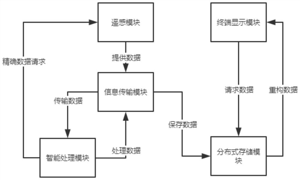
[0027] A geographical information cloud storage system based on topology, including a distributed storage module, a remote sensing module, an information transmission module, an intelligent processing module and a terminal display module, the remote sensing module is used to capture high-definition images and provide high-precision measurement data, The information transmission module sends the image and the measurement data to the intelligent processing module, and the intelligent processing module analyzes the image and combines the measurement data for topological structure to form a plurality of interrelated A data packet, the data packet is stored in each storage point of the distributed storage module, and the terminal display module requests the data packet from the distributed storage module and reconstructs it into a visual model for display;
[0028] The intelligent processing module divides geographic areas into basic geographic areas and human geographic areas, and ...
Embodiment 2
[0037] A geographical information cloud storage system based on topology, including a distributed storage module, a remote sensing module, an information transmission module, an intelligent processing module and a terminal display module, the remote sensing module is used to capture high-definition images and provide high-precision measurement data, The information transmission module sends the image and the measurement data to the intelligent processing module, and the intelligent processing module analyzes the image and combines the measurement data for topological structure to form a plurality of interrelated A data packet, the data packet is stored in each storage point of the distributed storage module, and the terminal display module requests the data packet from the distributed storage module and reconstructs it into a visual model for display;
[0038] The intelligent processing module divides geographic areas into basic geographic areas and human geographic areas, and ...
Embodiment 3
[0057] A geographical information cloud storage system based on topology, including a distributed storage module, a remote sensing module, an information transmission module, an intelligent processing module and a terminal display module, the remote sensing module is used to capture high-definition images and provide high-precision measurement data, The information transmission module sends the image and the measurement data to the intelligent processing module, and the intelligent processing module analyzes the image and combines the measurement data for topological structure to form a plurality of interrelated A data packet, the data packet is stored in each storage point of the distributed storage module, and the terminal display module requests the data packet from the distributed storage module and reconstructs it into a visual model for display;
[0058] The intelligent processing module divides geographic areas into basic geographic areas and human geographic areas, and ...
PUM
 Abstract
Description
Claims
Application Information
 - R&D
- Intellectual Property
- Life Sciences
- Materials
- Tech Scout
- Unparalleled Data Quality
- Higher Quality Content
- 60% Fewer Hallucinations
Browse by: Latest US Patents, China's latest patents, Technical Efficacy Thesaurus, Application Domain, Technology Topic, Popular Technical Reports.
© 2025 PatSnap. All rights reserved.Legal|Privacy policy|Modern Slavery Act Transparency Statement|Sitemap|About US| Contact US: help@patsnap.com


