
Method for enhancing short-distance large-height-difference RTK (Real-Time Kinematic) positioning by utilizing surface meteorological station

A short-range, weather station technology, used in satellite radio beacon positioning systems, instruments, measuring devices, etc., can solve the problems of poor positioning accuracy, large tropospheric delay, and inaccurate expression of tropospheric delay, achieving simple construction and low cost. , RTK positioning accuracy effect

Active Publication Date: 2021-06-18
长江空间信息技术工程有限公司(武汉) +2
View PDF6 Cites 5 Cited by
  • Summary
  • Abstract
  • Description
  • Claims
  • Application Information

AI Technical Summary

Problems solved by technology

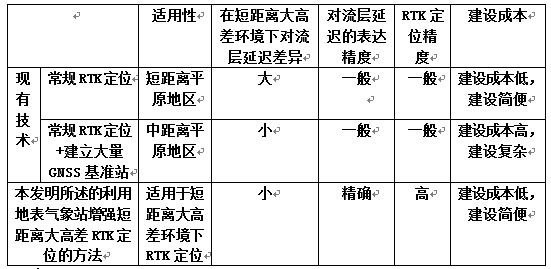
[0002] Conventional RTK positioning (RTK (Real-time kinematic, real-time dynamic) carrier phase difference technology) generally assumes that the errors between the base station and the rover are similar, and most errors can be weakened and eliminated through the difference; However, due to the large difference in tropospheric delay, after the second difference, the residual tropospheric delay is still relatively large; because conventional RTK usually uses a tropospheric delay model based on standard meteorological parameters (such as the Hopfield model or Saastamoinen model), the expression of the tropospheric delay is not enough Accurate, resulting in poor positioning accuracy in the vertical direction of RTK, and even cannot be fixed;

Method used


Image

  • Method for enhancing short-distance large-height-difference RTK (Real-Time Kinematic) positioning by utilizing surface meteorological station
  • Method for enhancing short-distance large-height-difference RTK (Real-Time Kinematic) positioning by utilizing surface meteorological station

Examples


Embodiment

[0057] Now, the application of the present invention to enhance the RTK positioning results of the reference station in a short baseline and large elevation difference area of ​​an alpine valley is an embodiment to describe the present invention in detail, and it also has a guiding role for the application of the present invention to enhance the RTK positioning effect under other short baseline and large elevation difference situations .

[0058] In this embodiment, the horizontal distance of the reference station in an area with a short baseline and a large elevation difference in an alpine valley is 5 km, and the elevation difference is 600 m.

[0059] In this embodiment, surface meteorological stations are used to enhance short-distance and large-height-difference RTK positioning. The specific method is as follows,

[0060] Step 1: In the environment of short distance and large height difference, use the existing site selection and evenly arrange multiple surface meteorolog...


PUM


Abstract

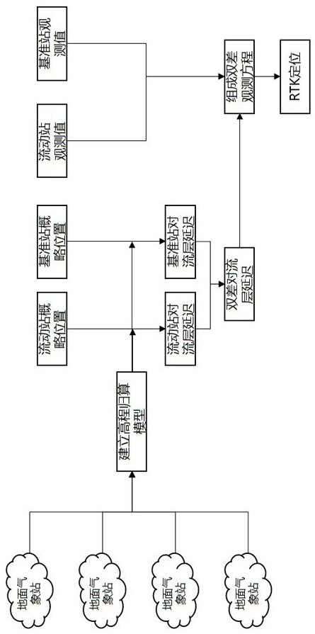
The invention discloses a method for enhancing short-distance large-height-difference RTK (Real-Time Kinematic) positioning by utilizing an earth surface meteorological station. The method comprises the following steps: step 1, arranging a plurality of surface meteorological observation stations in a short-distance and large-height-difference environment; step 2, collecting surface meteorological observation values of all surface meteorological observation stations in the area, carrying out troposphere delay modeling, and establishing an elevation reduction model of each meteorological parameter; step 3, calculating troposphere delays at a base station and a moving station; step 4, calculating double-difference troposphere delay; and step 5, substituting the double-difference troposphere delay obtained by calculation into an RTK observation equation, and further carrying out RTK positioning. The method overcomes the defect that in the prior art, in a short-distance large-height-difference environment, due to the fact that the troposphere delay difference is too large, the residual troposphere delay is large after secondary difference; and the method has the advantages of being accurate in troposphere delay expression and high in RTK vertical direction positioning accuracy.

Description

technical field [0001] The invention relates to the technical field of GNSS positioning, RTK positioning, and RTK positioning in short-distance and large-height-difference environments, and more specifically, it is a method for enhancing short-distance and large-height-difference RTK positioning by using surface weather stations. Background technique [0002] Conventional RTK positioning (RTK (Real-time kinematic, real-time dynamic) carrier phase difference technology) generally assumes that the errors between the base station and the rover are similar, and most errors can be weakened and eliminated through the difference; However, due to the large difference in tropospheric delay, after the second difference, the residual tropospheric delay is still relatively large; because conventional RTK usually uses a tropospheric delay model based on standard meteorological parameters (such as the Hopfield model or Saastamoinen model), the expression of the tropospheric delay is not en...

Claims


Application Information

Patent Timeline
IPC IPC(8): G01S19/43G01S19/03
CPCG01S19/03G01S19/43
Inventor 姚宜斌於三大杨爱明张良权录年马能武伍中华张辛肖玉钢张锋张琦袁乐先马瑞程渭炎张燊义崇政
Owner 长江空间信息技术工程有限公司(武汉)
Learn More