
Extraction of damaged buildings from remote sensing images based on multi-scale scene change detection

A technology of scene changes and remote sensing images, applied in the directions of instruments, calculations, character and pattern recognition, etc., can solve the problems of blurred building boundaries, extraction interference of damaged buildings, lack of task-specific thinking, etc., and achieve the effect of retaining outline information

Active Publication Date: 2021-08-31
SOUTHWEST JIAOTONG UNIV
View PDF5 Cites 2 Cited by
  • Summary
  • Abstract
  • Description
  • Claims
  • Application Information

AI Technical Summary

Problems solved by technology

However, most of the current research work directly transfers the deep learning model suitable for natural image understanding to the extraction of damaged buildings, and lacks specific thinking on this task. The main performance is: ①Semantic segmentation-based methods require pixel-level fine However, the boundaries of damaged buildings on post-disaster high-resolution remote sensing images are blurred, making it extremely difficult to obtain pixel-level labeled samples, and the quality of labeling cannot be guaranteed; , but the actual detection usually uses a fixed-size sliding window to traverse the image, ignoring the scale difference of the ground objects, and the interpretation result is often rough; ③The difficulty of labeling samples based on the target recognition method is between the above two, but It can only locate damaged buildings, and cannot retain the outline information of ground objects.
[0005] In addition, there are blurred boundaries of damaged buildings on post-disaster high-resolution remote sensing images, which is not conducive to the precise positioning of damaged buildings, and other ground objects such as gravel piles and soil mounds on the images are likely to interfere with the extraction of damaged buildings The problem

Method used


Image

  • Extraction of damaged buildings from remote sensing images based on multi-scale scene change detection
  • Extraction of damaged buildings from remote sensing images based on multi-scale scene change detection
  • Extraction of damaged buildings from remote sensing images based on multi-scale scene change detection

Examples


Embodiment Construction

[0045] In order to make the object, technical solution and advantages of the present invention clearer, the present invention will be further described in detail below in conjunction with the accompanying drawings and embodiments. It should be understood that the specific embodiments described here are only used to explain the present invention, not to limit the present invention.

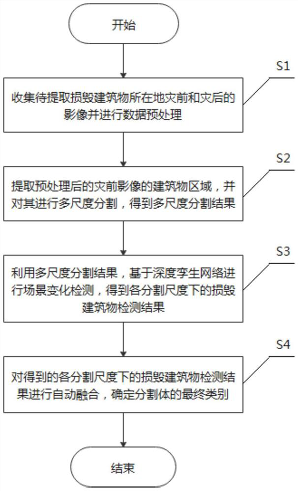
[0046] Please refer to figure 1 The present invention provides a method for extracting damaged buildings from remote sensing images based on multi-scale scene change detection, comprising the following steps:

[0047] S1. Collect pre-disaster and post-disaster images of the damaged buildings to be extracted and perform data preprocessing;

[0048] In the embodiment of the present invention, step S1 includes the following sub-steps:

[0049] S11. Collect pre-disaster and post-disaster images of the location of the damaged building to be extracted;

[0050] S12. With the help of ENVI Classic softwar...


PUM


Abstract

The invention discloses a method for extracting damaged buildings from remote sensing images based on multi-scale scene change detection. The method includes collecting pre-disaster and post-disaster images of the location of the damaged buildings to be extracted and performing data preprocessing; extracting the pre-disaster image of the pre-processed building area, and performing multi-scale segmentation on it to obtain multi-scale segmentation results; Based on the multi-scale segmentation results, the scene change detection is performed based on the deep twin network, and the detection results of damaged buildings at each segmentation scale are obtained; the detection results of damaged buildings at each segmentation scale are automatically fused to determine the final category of the segmentation body. In order to solve the problem that the traditional damaged building detection method has high requirements for sample labeling and poor contour fidelity of detection results, the invention uses a scene change detection model based on a deep twin network, and combines the multi-scale segmentation results of the building area with the scene change detection The results are effectively fused, and the outline information of the building is relatively completely preserved.

Description

technical field [0001] The invention relates to a method for extracting damaged buildings from remote sensing images, in particular to a method for extracting damaged buildings from remote sensing images based on multi-scale scene change detection. Background technique [0002] The construction area is the main place for human activities, and it is also the area with the most serious casualties and property losses when disasters occur. Therefore, after a disaster occurs, it is of great significance to quickly and accurately assess the damage of buildings in the disaster-stricken area for emergency rescue, decision-making command, and post-disaster reconstruction. Remote sensing technology has become one of the main technical means of disaster monitoring and assessment because of its macroscopic, efficient and convenient characteristics. In particular, the increasing availability of high-resolution remote sensing images makes it possible to extract large-scale and fine-grain...

Claims


Application Information

Patent Timeline
Patent Type & Authority Patents(China)
IPC IPC(8): G06K9/00G06K9/34G06K9/46G06K9/62
CPCG06V20/176G06V10/267G06V10/44G06F18/24
Inventor 慎利张文俊乔文凡
Owner SOUTHWEST JIAOTONG UNIV
Learn More