River-oriented multi-unmanned aerial vehicle water quality sampling and monitoring path optimization method

A water quality sampling and multi-UAV technology, which is applied in the direction of sampling device, vehicle position/route/height control, non-electric variable control, etc., can solve the problem of not meeting the monitoring time synchronization of multiple monitoring points and the low efficiency of monitoring task execution advanced questions

Active Publication Date: 2021-04-30
合肥一森电子科技有限公司
View PDF11 Cites 6 Cited by
  • Summary
  • Abstract
  • Description
  • Claims
  • Application Information

AI Technical Summary

Problems solved by technology

[0005] When a single UAV is used for water quality sampling and monitoring, due to the limitation of the UAV's own battery life, one flight can only complete the monitoring tasks of some sampling points, the execution efficiency of monitoring tasks is not high, and it does not satisfy multiple monitoring points. Requirements to maintain synchronization as much as possible in monitoring time

Method used


Image

  • River-oriented multi-unmanned aerial vehicle water quality sampling and monitoring path optimization method
  • River-oriented multi-unmanned aerial vehicle water quality sampling and monitoring path optimization method
  • River-oriented multi-unmanned aerial vehicle water quality sampling and monitoring path optimization method

Examples


specific Embodiment

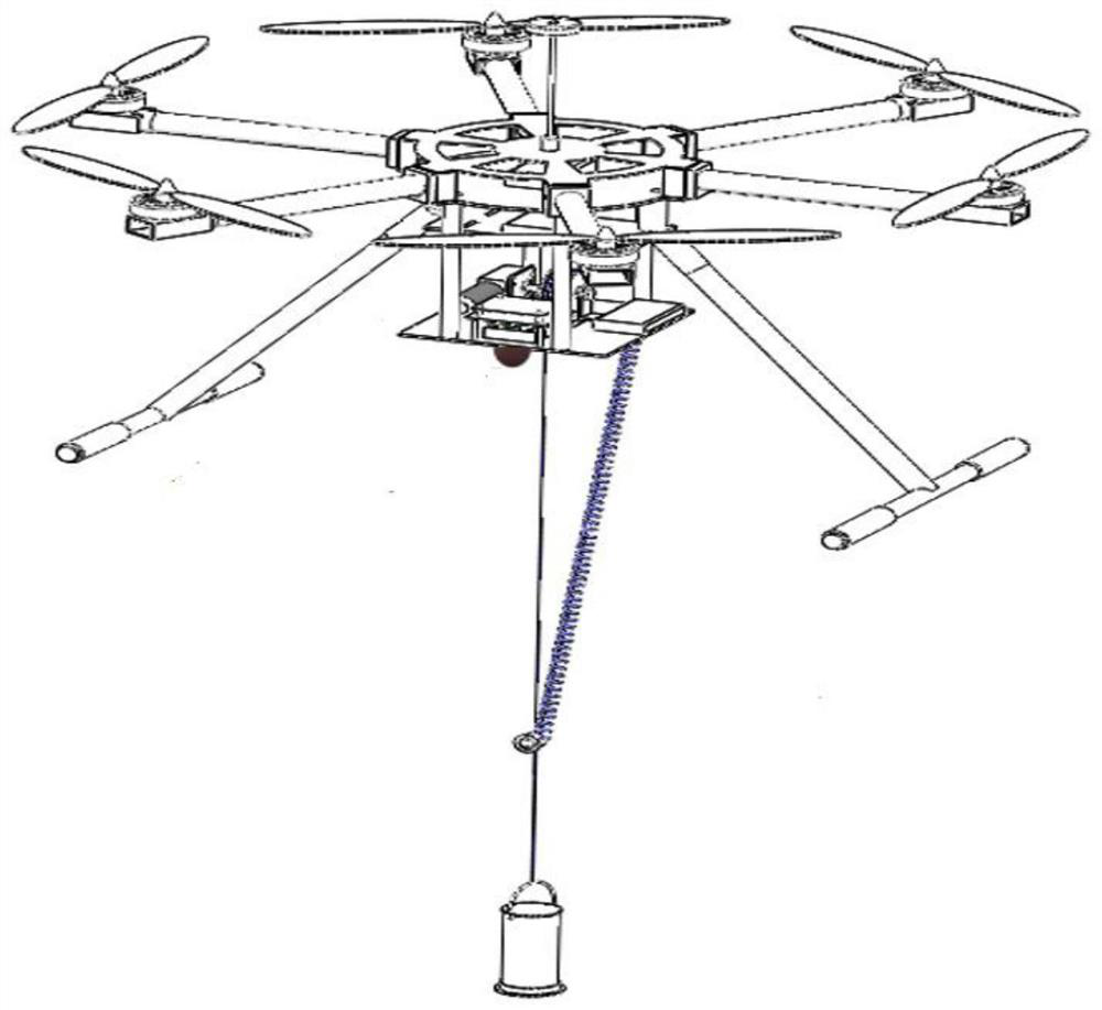
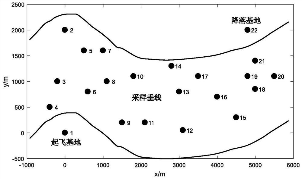
[0054] In this example, the take-off and landing bases are respectively set on the left and right banks of the river, numbered 1 and 22 respectively; a total of 20 water quality sampling vertical lines are arranged, numbered 2-21; each sampling vertical line is based on the water depth of the location, Set 1 to 3 sampling points; the hovering time of the UAV at each sampling vertical position is calculated according to the number of sampling points and pollutant categories on the vertical line; see Table 1 and Table 1 for specific information. image 3 shown.

[0055] Table 1 shows the distribution plan of river water quality sampling and monitoring;

[0056]

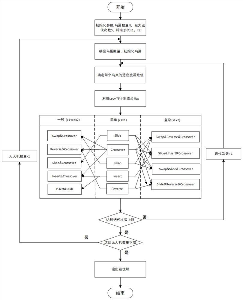
[0057] Set the maximum flight distance of a single UAV S=7.2km, the number of UAVs m=4, and the average flight speed of UAVs to 5m / s; see the specific calculation process figure 2 shown.

[0058] Set the specific objective function formula (1) to formula (3) of the model;

[0059] Set the specific constraints for...


PUM


Abstract

The invention discloses a river-oriented multi-unmanned aerial vehicle water quality sampling and monitoring path optimization method. According to the method, an objective function and constraint conditions are constructed for specific problems of river water quality sampling and monitoring, and the shortest total length of monitoring paths of all unmanned aerial vehicles and optimization of the number of the unmanned aerial vehicles are considered in the objective function; the specific constraint conditions comprise endurance time limitation of a single unmanned aerial vehicle, limitation of the number of sampling vertical lines on hovering time, limitation of the number of sampling points on the sampling vertical lines on the hovering time, limitation of pollutant types monitored by the sampling points on the hovering time, and difference limitation of flight and hovering unit energy consumption of the unmanned aerial vehicle, and limitation of unmanned aerial vehicle takeoff and landing bases distributed on left and right banks of river. Then the planning model is optimized by adopting the multi-filial-generation discrete cuckoo algorithm. According to the method, an optimal multi-unmanned aerial vehicle water quality sampling and monitoring path can be quickly calculated for a specific river water area environment.

Description

technical field [0001] The invention belongs to the technical field of water quality sampling and monitoring, and relates to a river-oriented multi-UAV water quality sampling and monitoring path optimization method. Background technique [0002] At present, most river water quality sampling is manual on-site sampling. This sampling method requires a lot of preparatory work, which has a long cycle, low work efficiency, and consumes a lot of manpower and material resources. Especially when water quality sampling is carried out in the field, due to the limited environmental conditions, sampling personnel often can only conduct water quality sampling on the banks of rivers, resulting in insufficient representativeness of water samples. Sometimes the staff will use tools such as unmanned ships, but when the water surface is seriously polluted or there are a lot of floating objects, the unmanned ships will be hindered and unable to reach the target location of sampling. [0003] ...

Claims


Application Information

Patent Timeline
Patent Type & Authority Applications(China)
IPC IPC(8): G05D1/10G01N1/10
CPCG05D1/101G01N1/10
Inventor 丁涛徐铭驰张广朋魏坤高奇石
Owner 合肥一森电子科技有限公司
Why Eureka
Try Eureka