Section diagram generation method, system and device and storage medium

A cross-sectional diagram and cross-section technology, applied in image data processing, 3D modeling, instruments, etc., can solve problems such as unfavorable work safety, low efficiency, and difficulty for surveyors to reach, shortening operation time, reducing operation intensity, The effect of ensuring work safety

Pending Publication Date: 2021-04-20
广州天勤数字科技有限公司 +2
View PDF0 Cites 2 Cited by
  • Summary
  • Abstract
  • Description
  • Claims
  • Application Information

AI Technical Summary

Problems solved by technology

In the existing technology, surveyors are required to carry total stations, GPS TRK measuring instruments and other instruments to carry out step-by-step surveys, and the construction areas that need to make cross-sectional diagrams are often complex in terrain, dense in vegetation, and vast in area, and there are many areas that are difficult for surveyors to reach. The method of manual surveying is high in intensity, low in efficiency, and incomplete in data sampling. It is difficult to obtain topographic data at any point or section, and it is not conducive to the work safety of surveyors.

Method used


Image

  • Section diagram generation method, system and device and storage medium
  • Section diagram generation method, system and device and storage medium
  • Section diagram generation method, system and device and storage medium

Examples


Embodiment Construction

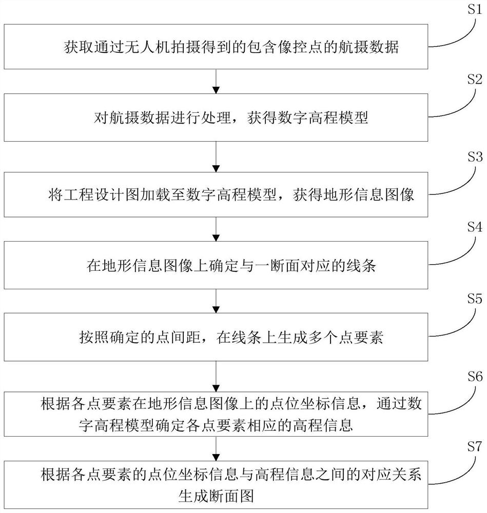
[0055] In this example, refer to figure 1 , the cross-sectional view generation method includes the following steps:

[0056] S1. Obtain the aerial photography data including image control points captured by the drone;

[0057] S2. Process the aerial photography data to obtain a digital elevation model;

[0058] S3. Load the engineering design drawing into the digital elevation model to obtain the terrain information image;

[0059] S4. Determining a line corresponding to a section on the terrain information image;

[0060] S5. Generate multiple point elements on the line according to the determined point spacing;

[0061] S6. According to the point coordinate information of each point element on the terrain information image, determine the corresponding elevation information of each point element through the digital elevation model;

[0062] S7. Generate a cross-sectional view according to the corresponding relationship between point coordinate information and elevation i...


PUM


Abstract

The invention discloses a cross-section diagram generation method and system, a computer device and a storage medium. The method comprises steps of obtaining aerial photography data through an unmanned plane, and carrying out the processing of the aerial photography data to obtain a digital elevation model, a topographic information image, a point element, point position coordinate information and elevation information, and generating a section diagram according to the corresponding relation between the point position coordinate information and the elevation information. The method is advantaged in that the unmanned aerial vehicle is used for collecting aerial photography data, image processing such as digital elevation model generation and terrain information image generation is carried out on the aerial photography data, information of areas where more people cannot reach can be collected, and measuring personnel can obtain section diagrams of more positions at a computer side in a man-machine interaction mode and the like; the method has high convenience, greatly reduces the operation intensity of measurement personnel, shortens the operation time, improves the operation efficiency, can assist the engineering construction, and effectively guarantees the work safety of the measurement personnel. The method is widely applied to the technical field of engineering data measurement.

Description

technical field [0001] The invention relates to the technical field of engineering data measurement, in particular to a method, system, computer device and storage medium for generating a section view. Background technique [0002] In the construction process of infrastructure and other engineering projects, it is necessary to obtain more accurate 3D terrain data as a basis for design and changes. In the existing technology, surveyors are required to carry total stations, GPS TRK measuring instruments and other instruments to carry out step-by-step surveys, and the construction areas that need to make cross-sectional diagrams are often complex in terrain, dense in vegetation, and vast in area, and there are many areas that are difficult for surveyors to reach. The method of manual surveying is intensive, inefficient, and data sampling is not comprehensive. It is difficult to obtain topographic data at any point or section, and it is not conducive to the work safety of survey...

Claims


Application Information

Patent Timeline
Patent Type & Authority Applications(China)
IPC IPC(8): G06T11/20G06T17/05
Inventor 汪新天卢照孔王振华耿少鹏王成功陶沈圣温楷和柳楠徐海龙张祥黎明亮
Owner 广州天勤数字科技有限公司
Why Eureka
Try Eureka