Visualization platform and method for risk level evaluation of enterprise emergency environment event
A technology of environmental risk and risk level, applied in the field of visual platform for level evaluation, can solve the problems of difficult data acquisition, low efficiency, high cost, etc., and achieve the effect of convenient use
- Summary
- Abstract
- Description
- Claims
- Application Information
AI Technical Summary
Problems solved by technology
Method used
Image
Examples
Embodiment Construction
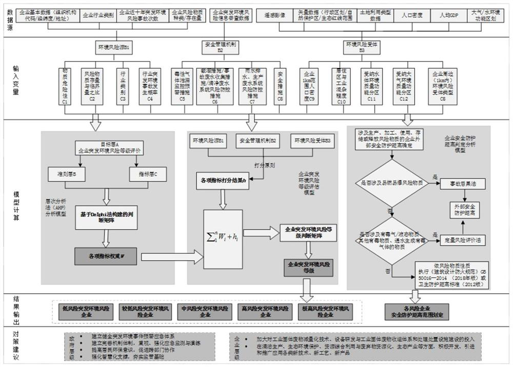
[0052] The present invention will be further described in conjunction with the accompanying drawings and specific embodiments.
[0053] Such as figure 1 and 2 As shown in Fig. 1, a visual platform for evaluating the risk level of enterprise environmental emergencies is used to quickly and quasi-real-time evaluate the enterprise environmental emergency risk level. The visualization platform of the present invention adopts a B / S architecture, which can realize maximum cross-platform sharing and meet users' browsing needs on PCs, tablets and mobile phones. On the Web side, the present invention selects Mapbox, a benchmark in the map and cartography industry, as the development platform base for spatial data visualization, and uses WebGL to combine Java Script and Open GLES2.0, and calls GPU to provide 3D hardware-accelerated rendering during browser access. The specific software environment is shown in Table 1;
[0054] Table 1 Platform software environment
[0055] s...
PUM
 Abstract
Description
Claims
Application Information
 - R&D
- Intellectual Property
- Life Sciences
- Materials
- Tech Scout
- Unparalleled Data Quality
- Higher Quality Content
- 60% Fewer Hallucinations
Browse by: Latest US Patents, China's latest patents, Technical Efficacy Thesaurus, Application Domain, Technology Topic, Popular Technical Reports.
© 2025 PatSnap. All rights reserved.Legal|Privacy policy|Modern Slavery Act Transparency Statement|Sitemap|About US| Contact US: help@patsnap.com


