Double-time-phase high-resolution remote sensing image change detection algorithm

A remote sensing image, high-resolution technology, applied in the field of remote sensing surveying and mapping geographic information, can solve problems such as difficult and effective detection of change areas, achieve the effect of improving OA indicators and solving the problem of multi-resolution image change detection

Pending Publication Date: 2021-03-30
土豆数据科技集团有限公司
View PDF0 Cites 3 Cited by
  • Summary
  • Abstract
  • Description
  • Claims
  • Application Information

AI Technical Summary

Problems solved by technology

[0005] The category of change is identified by classifying the extracted bitemporal data features. The general method is to assign a change score to each position of the image, where the position of change has a higher score than the position of no change, through the weight of the category Set to solve the problem of category imbalance, adopt CNN method, RNN method, capture sequence relationship, model time dependence, some models that combine CNN and RNN, it is difficult to effectively detect change areas with different size and resolution of photographic data

Method used


Image

  • Double-time-phase high-resolution remote sensing image change detection algorithm
  • Double-time-phase high-resolution remote sensing image change detection algorithm
  • Double-time-phase high-resolution remote sensing image change detection algorithm

Examples


Embodiment Construction

[0030] The following will clearly and completely describe the technical solutions in the embodiments of the present invention with reference to the accompanying drawings in the embodiments of the present invention. Obviously, the described embodiments are only some, not all, embodiments of the present invention. Based on the embodiments of the present invention, all other embodiments obtained by persons of ordinary skill in the art without making creative efforts belong to the protection scope of the present invention.

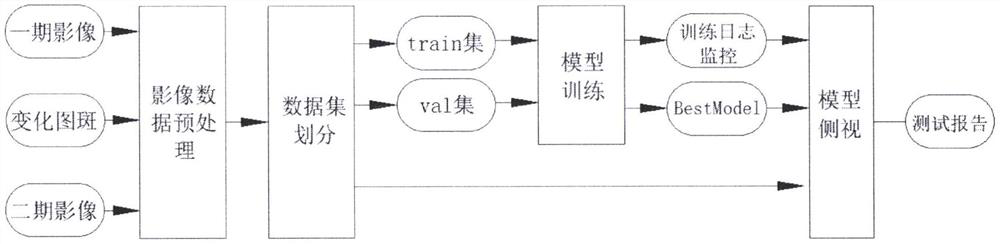
[0031] Such as Figure 1-5 As shown, the present invention provides a technical solution: a dual-temporal high-resolution remote sensing image change detection algorithm, the method comprising the following steps:

[0032] A. Image collection: the satellite camera unit collects remote sensing image data of multiple times and performs registration;

[0033] B. Image preprocessing: convert each IMG source data image into vector, raster, and PNG formats;

[003...


PUM


Abstract

The invention discloses a double-time-phase high-resolution remote sensing image change detection algorithm, which relates to the technical field of remote sensing surveying and mapping geographic information, and comprises the steps of A, image acquisition, that is, a satellite photographing unit acquires multi-time remote sensing image data and registers the multi-time remote sensing image data;and B, image preprocessing, that is, vector, grid and PNG format conversion is performed on each IMG source data image. According to the double-time-phase high-resolution remote sensing image changedetection algorithm, multi-scale features can be obtained by combining the features of regions of different sizes, an image space is averagely divided into sub-regions of a certain scale under the driving of the motivation, a self-attention mechanism is introduced into each sub-region, and by utilizing the space-time relationship of an object under the scale and dividing the image into multi-scalesub-regions, multi-scale feature representation can be obtained so as to better adapt to the scale of the target.

Description

technical field [0001] The invention relates to the technical field of remote sensing surveying and mapping geographic information, in particular to a dual-temporal high-resolution remote sensing image change detection algorithm. Background technique [0002] Change detection is of great significance in the interpretation of remote sensing images. High-resolution remote sensing images have greatly improved the ability to monitor land use and cover changes. Multi-temporal high-resolution remote sensing images contain complex geographic information elements. Using Deep learning for automatic change detection of remote sensing images has developed rapidly in the past two years, and its accuracy and efficiency have far surpassed traditional methods. Aiming at the problem of dual-temporal high-resolution remote sensing change detection, this patent proposes a deep convolutional neural network for target change areas. The network has realized the end-to-end change detection functi...

Claims


Application Information

Patent Timeline
Patent Type & Authority Applications(China)
IPC IPC(8): G01C11/04G06K9/52G06K9/62G06N3/04G06N3/08
CPCG01C11/04G06N3/08G06V10/52G06N3/045G06F18/214
Inventor 赵金剑王江安
Owner 土豆数据科技集团有限公司
Why Eureka
Try Eureka